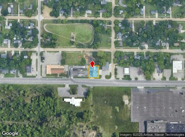
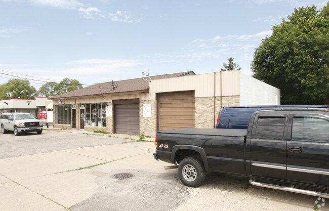
Property Record
3156 W Pierson Rd, Flint, MI 48504

NEARBY LISTINGS FOR SALE OR LEASE
Property Detail
3156 W Pierson Rd
Flint, MI
Mayfair 1
14-27-576-144
LOTS 3 & 4 BLK 11 MAYFAIR NO 1 (86) FR 1400194158
Commercialnec
Genesee
X
Michigan
26049C0186D
3-4
2024
0.25 AC
2025
Flint
010501
Detroit
DEMOGRAPHICS near 3156 W Pierson Rd
1 Mile
3 Mile
5 Mile
2024 Total Population
7,042
60,085
125,213
2029 Population
7,178
61,928
126,858
Pop Growth 2024-2029
+ 1.93%
+ 3.07%
+ 1.31%
Average Age
40
40
40
2024 Total Households
2,939
24,896
51,656
HH Growth 2024-2029
+ 2.08%
+ 3.09%
+ 1.28%
Median Household Inc
$36,187
$34,091
$38,101
Avg Household Size
2.30
2.30
2.30
2024 Avg HH Vehicles
1.00
1.00
1.00
Median Home Value
$62,205
$65,237
$77,489
Median Year Built
1961
1961
1960
Nearby Places
Map Layers
Map Styles
 Street
 Aerial
- Restaurants
- Banks
- Shops
- Fitness
- Groceries
PUBLIC TRANSPORTATION
COMMUTER RAIL
Flint Amtrak Station (Blue Water - Amtrak)
DRIVE
WALK
Distance
Flint Amtrak Station (Blue Water - Amtrak)
15 min
7.3 mi
AIRPORT
Bishop International
DRIVE
WALK
Distance
Bishop International
25 min
11.6 mi
Freight Ports
Port of Toledo
DRIVE
WALK
Distance
Port of Toledo
138 min
117.7 mi
Nearby Properties
Address
Land Use
TOTAL SIZE
Lot Size
Zoning
Address
Land Use
TOTAL SIZE
Lot Size
Zoning
54,651 SF
3.06 AC
Address
Land Use
TOTAL SIZE
Lot Size
Zoning
571,389 SF
584 AC
Address
Land Use
TOTAL SIZE
Lot Size
Zoning
247,555 SF
198 AC
Address
Land Use
TOTAL SIZE
Lot Size
Zoning
290,502 SF
272.83 AC
Address
Land Use
TOTAL SIZE
Lot Size
Zoning
182,408 SF
Address
Land Use
TOTAL SIZE
Lot Size
Zoning
157,068 SF
160 AC
Address
Land Use
TOTAL SIZE
Lot Size
Zoning
11.97 AC
Address
Land Use
TOTAL SIZE
Lot Size
Zoning
10.30 AC
Address
Land Use
TOTAL SIZE
Lot Size
Zoning
Address
Land Use
TOTAL SIZE
Lot Size
Zoning
59,173 SF
11.43 AC
Address
Land Use
TOTAL SIZE
Lot Size
Zoning
Address
Land Use
TOTAL SIZE
Lot Size
Zoning
224,263 SF
24.98 AC
CC
Address
Land Use
TOTAL SIZE
Lot Size
Zoning
11.12 AC
Address
Land Use
TOTAL SIZE
Lot Size
Zoning
101,744 SF
4.90 AC
TN-2
Address
Land Use
TOTAL SIZE
Lot Size
Zoning
33.39 AC
Address
Land Use
TOTAL SIZE
Lot Size
Zoning
26,106 SF
2.53 AC
Address
Land Use
TOTAL SIZE
Lot Size
Zoning
9.46 AC
Address
Land Use
TOTAL SIZE
Lot Size
Zoning
13.20 AC
Address
Land Use
TOTAL SIZE
Lot Size
Zoning
Address
Land Use
TOTAL SIZE
Lot Size
Zoning
2.45 AC
Address
Land Use
TOTAL SIZE
Lot Size
Zoning
5.10 AC
Address
Land Use
TOTAL SIZE
Lot Size
Zoning
104.81 AC
Address
Land Use
TOTAL SIZE
Lot Size
Zoning
Address
Land Use
TOTAL SIZE
Lot Size
Zoning
5.70 AC
Address
Land Use
TOTAL SIZE
Lot Size
Zoning
2.02 AC
Address
Land Use
TOTAL SIZE
Lot Size
Zoning
70,344 SF
72 AC
Address
Land Use
TOTAL SIZE
Lot Size
Zoning
1.41 AC
Address
Land Use
TOTAL SIZE
Lot Size
Zoning
19.75 AC
Address
Land Use
TOTAL SIZE
Lot Size
Zoning
100,022 SF
92 AC
Address
Land Use
TOTAL SIZE
Lot Size
Zoning
18.66 AC
The World's #1 Commercial Real Estate Marketplace
Connect with us
© 2025 CoStar Group
The information above has been obtained from sources believed reliable. While we do not doubt its accuracy we have not verified it and make no guarantee, warranty or representation about it. It is your responsibility to independently confirm its accuracy and completeness. Any projections, opinions, assumptions, or estimates used are for example only and do not represent the current or future performance of the property. The value of this transaction to you depends on tax and other factors which should be evaluated by your tax, financial, and legal advisors. You and your advisors should conduct a careful, independent investigation of the property to determine to your satisfaction the suitability of the property for your needs.