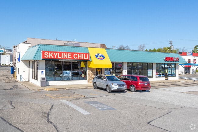
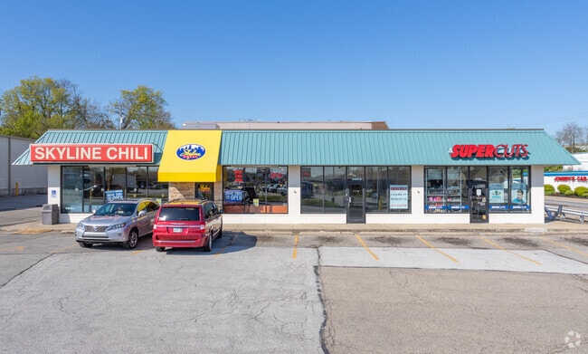
Property Record
3159 Dixie Hwy, Erlanger, KY 41018

Save to a Folder
{{folder.Name}}
{{folder.ListingIds.length}} Properties
{{folder.ListingIds.length}} Property
Create a New Folder
Property Detail
3159 Dixie Hwy
015-20-31-004.04
0.39 AC OR 100 X 170 APPROX 360 FT NE OF SEC DIXIE HGWY & CLOVER AVE
Storebuilding
Kenton
B and X Area of moderate flood hazard, usually the area between the limits of the 100-year and 500-year floods.
Kentucky
2025
0.39 AC
2025
Cincinnati Intl Airport
065700
Cincinnati/Dayton
5,228 SF
Cincinnati, OH-KY-IN
NEARBY LISTINGS FOR SALE OR LEASE
DEMOGRAPHICS near 3159 Dixie Hwy
1 mile
3 mile
5 mile
2025 Total Population
10,348
72,518
143,779
2030 Population
10,638
75,115
149,283
Pop Growth 2025-2030
+ 2.80%
+ 3.58%
+ 3.83%
Average Age
40
40
40
2025 Total Households
4,329
29,029
57,302
HH Growth 2025-2030
+ 2.75%
+ 3.59%
+ 3.86%
Median Household Inc
$74,040
$76,540
$77,865
Avg Household Size
2.30
2.40
2.40
2025 Avg HH Vehicles
2.00
2.00
2.00
Median Home Value
$215,020
$244,077
$248,570
Median Year Built
1966
1975
1978
Nearby Places
Map Layers
Map Styles
 Street
 Aerial
Layers
 Traffic
 Biking
Places
Listings with unknown addresses are not visible on the map
- Restaurants
- Banks
- Shops
- Fitness
- Groceries
PUBLIC TRANSPORTATION
COMMUTER RAIL
Cincinnati Union Terminal (Cardinal - Amtrak)
Drive
Walk
Distance
Cincinnati Union Terminal (Cardinal - Amtrak)
18 min
9.2 mi
AIRPORT
Cincinnati/Northern Kentucky International
Drive
Walk
Distance
Cincinnati/Northern Kentucky International
17 min
6.4 mi
Freight Ports
Port of Toledo
Drive
Walk
Distance
Port of Toledo
255 min
213.8 mi
Nearby Properties
Address
Land Use
TOTAL SIZE
Lot Size
Zoning
Address
Land Use
TOTAL SIZE
Lot Size
Zoning
Address
Land Use
TOTAL SIZE
Lot Size
Zoning
600 SF
196.95 AC
Address
Land Use
TOTAL SIZE
Lot Size
Zoning
43.58 AC
Address
Land Use
TOTAL SIZE
Lot Size
Zoning
Address
Land Use
TOTAL SIZE
Lot Size
Zoning
70.34 AC
Address
Land Use
TOTAL SIZE
Lot Size
Zoning
20.38 AC
Address
Land Use
TOTAL SIZE
Lot Size
Zoning
20.52 AC
Address
Land Use
TOTAL SIZE
Lot Size
Zoning
19.61 AC
Address
Land Use
TOTAL SIZE
Lot Size
Zoning
475,250 SF
37.16 AC
Address
Land Use
TOTAL SIZE
Lot Size
Zoning
13.62 AC
Address
Land Use
TOTAL SIZE
Lot Size
Zoning
1,170 SF
41.17 AC
Address
Land Use
TOTAL SIZE
Lot Size
Zoning
56.94 AC
Address
Land Use
TOTAL SIZE
Lot Size
Zoning
12.85 AC
Address
Land Use
TOTAL SIZE
Lot Size
Zoning
769,604 SF
14 AC
Address
Land Use
TOTAL SIZE
Lot Size
Zoning
Address
Land Use
TOTAL SIZE
Lot Size
Zoning
30.11 AC
Address
Land Use
TOTAL SIZE
Lot Size
Zoning
24.80 AC
Address
Land Use
TOTAL SIZE
Lot Size
Zoning
24.28 AC
Address
Land Use
TOTAL SIZE
Lot Size
Zoning
157,520 SF
18.05 AC
Address
Land Use
TOTAL SIZE
Lot Size
Zoning
50,536 SF
34.12 AC
Address
Land Use
TOTAL SIZE
Lot Size
Zoning
57,030 SF
7 AC
Address
Land Use
TOTAL SIZE
Lot Size
Zoning
16,406 SF
223.20 AC
Address
Land Use
TOTAL SIZE
Lot Size
Zoning
Address
Land Use
TOTAL SIZE
Lot Size
Zoning
85,726 SF
15.07 AC
Address
Land Use
TOTAL SIZE
Lot Size
Zoning
Address
Land Use
TOTAL SIZE
Lot Size
Zoning
Address
Land Use
TOTAL SIZE
Lot Size
Zoning
176,588 SF
24.35 AC
Address
Land Use
TOTAL SIZE
Lot Size
Zoning
435,320 SF
41.37 AC
Address
Land Use
TOTAL SIZE
Lot Size
Zoning
0.85 AC
Address
Land Use
TOTAL SIZE
Lot Size
Zoning
10.62 AC
The World's #1 Commercial Real Estate Marketplace
Connect with us
© 2026 CoStar Group
The information above has been obtained from sources believed reliable. While we do not doubt its accuracy we have not verified it and make no guarantee, warranty or representation about it. It is your responsibility to independently confirm its accuracy and completeness. Any projections, opinions, assumptions, or estimates used are for example only and do not represent the current or future performance of the property. The value of this transaction to you depends on tax and other factors which should be evaluated by your tax, financial, and legal advisors. You and your advisors should conduct a careful, independent investigation of the property to determine to your satisfaction the suitability of the property for your needs.