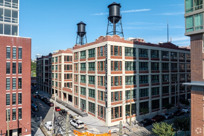
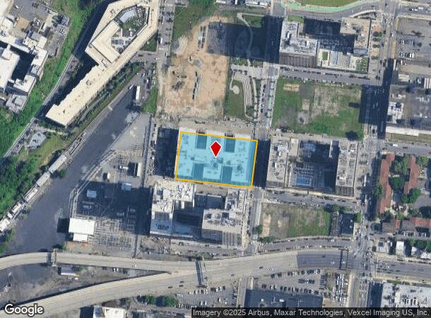
Property Record
316 15Th St, Hoboken, NJ 07030
Current Lease Availabilities
NEARBY LISTINGS FOR SALE OR LEASE
Property Detail
316 15Th St
06-06903-0000-00003-04
Hudson
Commercialnec
New Jersey
AE
3.4
34013C0200F
1.48 AC
2024
SoHo West
2025
Northern New Jersey
018800
New York-Jersey City-White Plains, NY-NJ
DEMOGRAPHICS near 316 15Th St
1 Mile
3 Mile
5 Mile
2024 Total Population
116,092
627,370
1,582,112
2029 Population
114,117
599,411
1,499,830
Pop Growth 2024-2029
(1.70%)
(4.46%)
(5.20%)
Average Age
36
38
39
2024 Total Households
52,254
285,360
740,882
HH Growth 2024-2029
(2.03%)
(4.83%)
(5.60%)
Median Household Inc
$113,586
$108,645
$102,573
Avg Household Size
2.20
2.10
2.00
2024 Avg HH Vehicles
1.00
1.00
.00
Median Home Value
$701,092
$795,290
$844,657
Median Year Built
1982
1961
1961
Nearby Places
- Restaurants
- Banks
- Shops
- Fitness
- Groceries
PUBLIC TRANSPORTATION
TRANSIT/SUBWAY
2Nd Street (Tonnelle Avenue-Hoboken Terminal - Hudson-Bergen Light Rail (Hudson-Bergen Light Rail), West Side Avenue-Tonnelle Avenue - Hudson-Bergen Light Rail (Hudson-Bergen Light Rail))
DRIVE
WALK
Distance
2Nd Street (Tonnelle Avenue-Hoboken Terminal - Hudson-Bergen Light Rail (Hudson-Bergen Light Rail), West Side Avenue-Tonnelle Avenue - Hudson-Bergen Light Rail (Hudson-Bergen Light Rail))
2 min
14 min
0.7 mi
Pavonia Newport (22nd Street-Hoboken Terminal - Hudson-Bergen Light Rail (Hudson-Bergen Light Rail), West Side Avenue-Tonnelle Avenue - Hudson-Bergen Light Rail (Hudson-Bergen Light Rail))
DRIVE
WALK
Distance
Pavonia Newport (22nd Street-Hoboken Terminal - Hudson-Bergen Light Rail (Hudson-Bergen Light Rail), West Side Avenue-Tonnelle Avenue - Hudson-Bergen Light Rail (Hudson-Bergen Light Rail))
3 min
19 min
1.0 mi
COMMUTER RAIL
Pavonia/Newport (Hoboken-World Trade Center - Port Authority Trans-Hudson (PATH), Journal Square-33rd Street - Port Authority Trans-Hudson (PATH))
DRIVE
WALK
Distance
Pavonia/Newport (Hoboken-World Trade Center - Port Authority Trans-Hudson (PATH), Journal Square-33rd Street - Port Authority Trans-Hudson (PATH))
4 min
20 min
1.0 mi
Journal Square (Journal Square-33rd Street - Port Authority Trans-Hudson (PATH), Newark Penn Station-World Trade Center - Port Authority Trans-Hudson (PATH))
DRIVE
WALK
Distance
Journal Square (Journal Square-33rd Street - Port Authority Trans-Hudson (PATH), Newark Penn Station-World Trade Center - Port Authority Trans-Hudson (PATH))
4 min
1.6 mi
AIRPORT
Newark Liberty International
DRIVE
WALK
Distance
Newark Liberty International
12 min
9.7 mi
LaGuardia
DRIVE
WALK
Distance
LaGuardia
29 min
12.9 mi
John F Kennedy International
DRIVE
WALK
Distance
John F Kennedy International
38 min
21.1 mi
Freight Ports
NY - Red Hook Container Terminal
DRIVE
WALK
Distance
NY - Red Hook Container Terminal
16 min
6.4 mi
Nearby Properties
Address
Land Use
TOTAL SIZE
Lot Size
Zoning
Address
Land Use
TOTAL SIZE
Lot Size
Zoning
4,060,596 SF
22.09 AC
M2-3
Address
Land Use
TOTAL SIZE
Lot Size
Zoning
2,521,850 SF
1.59 AC
C6-4
Address
Land Use
TOTAL SIZE
Lot Size
Zoning
1,445,092 SF
3.10 AC
C6-4
Address
Land Use
TOTAL SIZE
Lot Size
Zoning
2,221,336 SF
1.55 AC
C6-4
Address
Land Use
TOTAL SIZE
Lot Size
Zoning
9.33 AC
C-1
Address
Land Use
TOTAL SIZE
Lot Size
Zoning
2,161,994 SF
3.79 AC
M1-5
Address
Land Use
TOTAL SIZE
Lot Size
Zoning
2,354,289 SF
3.96 AC
C6-4
Address
Land Use
TOTAL SIZE
Lot Size
Zoning
1,946,157 SF
1.49 AC
C6-4
Address
Land Use
TOTAL SIZE
Lot Size
Zoning
1,178,640 SF
0.92 AC
C6-4
Address
Land Use
TOTAL SIZE
Lot Size
Zoning
2.38 AC
Address
Land Use
TOTAL SIZE
Lot Size
Zoning
1,751,641 SF
1.84 AC
C6-4
Address
Land Use
TOTAL SIZE
Lot Size
Zoning
6,877 SF
27.74 AC
UD
Address
Land Use
TOTAL SIZE
Lot Size
Zoning
1,805,894 SF
1.42 AC
C6-4
Address
Land Use
TOTAL SIZE
Lot Size
Zoning
1.75 AC
Address
Land Use
TOTAL SIZE
Lot Size
Zoning
2,157,862 SF
2.23 AC
BPC
Address
Land Use
TOTAL SIZE
Lot Size
Zoning
1,009,855 SF
4.90 AC
C6-3
Address
Land Use
TOTAL SIZE
Lot Size
Zoning
2,255,659 SF
4.58 AC
BPC
Address
Land Use
TOTAL SIZE
Lot Size
Zoning
Address
Land Use
TOTAL SIZE
Lot Size
Zoning
1,009,855 SF
3.25 AC
C6-3
Address
Land Use
TOTAL SIZE
Lot Size
Zoning
6.42 AC
Address
Land Use
TOTAL SIZE
Lot Size
Zoning
366,455 SF
3.23 AC
R
Address
Land Use
TOTAL SIZE
Lot Size
Zoning
2,233,692 SF
1.90 AC
BPC
Address
Land Use
TOTAL SIZE
Lot Size
Zoning
2.21 AC
Address
Land Use
TOTAL SIZE
Lot Size
Zoning
1,560,607 SF
2.69 AC
C6-6
Address
Land Use
TOTAL SIZE
Lot Size
Zoning
1.71 AC
C-1
Address
Land Use
TOTAL SIZE
Lot Size
Zoning
1,636,000 SF
1.09 AC
C6-4
Address
Land Use
TOTAL SIZE
Lot Size
Zoning
1,178,655 SF
4.57 AC
Address
Land Use
TOTAL SIZE
Lot Size
Zoning
1,281,169 SF
C6-4
Address
Land Use
TOTAL SIZE
Lot Size
Zoning
832,321 SF
4.57 AC
Address
Land Use
TOTAL SIZE
Lot Size
Zoning
1,909,502 SF
2.37 AC
BPC
The World's #1 Commercial Real Estate Marketplace
Connect with us
© 2025 CoStar Group
The information above has been obtained from sources believed reliable. While we do not doubt its accuracy we have not verified it and make no guarantee, warranty or representation about it. It is your responsibility to independently confirm its accuracy and completeness. Any projections, opinions, assumptions, or estimates used are for example only and do not represent the current or future performance of the property. The value of this transaction to you depends on tax and other factors which should be evaluated by your tax, financial, and legal advisors. You and your advisors should conduct a careful, independent investigation of the property to determine to your satisfaction the suitability of the property for your needs.