Property Record
316 N High St, Harrisonburg, VA 22802
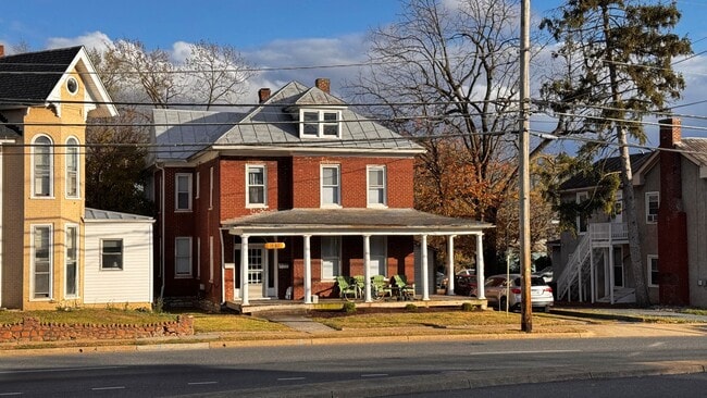
This Property Is For Sale
NEARBY LISTINGS FOR SALE OR LEASE
Property Detail
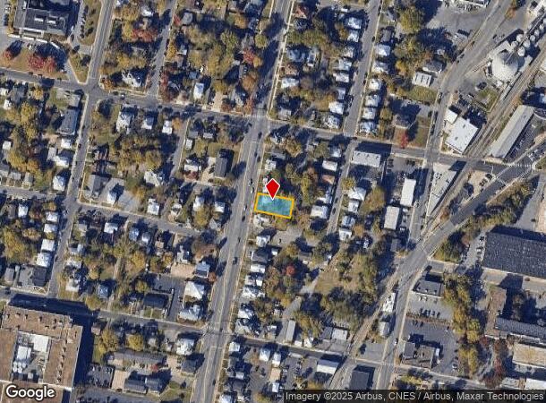
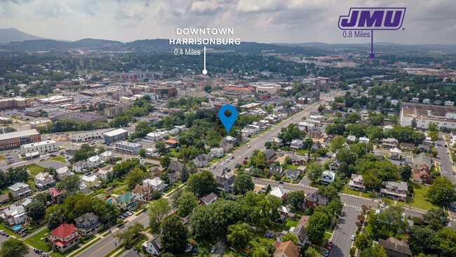
316 N High St
Harrisonburg, VA
Harrisonburg
035-K-11
Virginia
Duplex
0.17 AC
X
Downtown Harrisonburg
51165C0403D
Other Market Areas
2,432 SF
DEMOGRAPHICS near 316 N High St
1 Mile
3 Mile
5 Mile
2024 Total Population
13,153
55,944
73,385
2029 Population
13,097
55,917
74,218
Pop Growth 2024-2029
(0.43%)
(0.05%)
+ 1.14%
Average Age
34
33
35
2024 Total Households
4,751
18,922
25,541
HH Growth 2024-2029
(0.34%)
(0.07%)
+ 1.26%
Median Household Inc
$56,820
$61,266
$67,649
Avg Household Size
2.50
2.50
2.50
2024 Avg HH Vehicles
2.00
2.00
2.00
Median Home Value
$280,676
$308,476
$332,510
Median Year Built
1975
1988
1990
Nearby Places
- Restaurants
- Banks
- Shops
- Fitness
- Groceries
Nearby Properties
Address
Land Use
TOTAL SIZE
Lot Size
Zoning
Address
Land Use
TOTAL SIZE
Lot Size
Zoning
143.09 AC
MULTI DWEL
Address
Land Use
TOTAL SIZE
Lot Size
Zoning
114.53 AC
MULTI DWEL
Address
Land Use
TOTAL SIZE
Lot Size
Zoning
9.63 AC
MULTI DWEL
Address
Land Use
TOTAL SIZE
Lot Size
Zoning
100,172 SF
0.79 AC
MULTI DWEL
Address
Land Use
TOTAL SIZE
Lot Size
Zoning
10,560 SF
258 AC
MULTI DWEL
Address
Land Use
TOTAL SIZE
Lot Size
Zoning
36.81 AC
R5
Address
Land Use
TOTAL SIZE
Lot Size
Zoning
219,561 SF
55.38 AC
GENERAL IN
Address
Land Use
TOTAL SIZE
Lot Size
Zoning
40,887 SF
24.09 AC
MULTI DWEL
Address
Land Use
TOTAL SIZE
Lot Size
Zoning
768 SF
62.46 AC
SINGLE FAM
Address
Land Use
TOTAL SIZE
Lot Size
Zoning
1,656 SF
36.28 AC
GENERAL IN
Address
Land Use
TOTAL SIZE
Lot Size
Zoning
11.07 AC
RESIDENTIA
Address
Land Use
TOTAL SIZE
Lot Size
Zoning
236,916 SF
3.72 AC
MULTI DWEL
Address
Land Use
TOTAL SIZE
Lot Size
Zoning
172,594 SF
0.65 AC
MULTI DWEL
Address
Land Use
TOTAL SIZE
Lot Size
Zoning
16,620 SF
192 AC
HIGH DENSI
Address
Land Use
TOTAL SIZE
Lot Size
Zoning
14,490 SF
190 AC
PLANNED UN
Address
Land Use
TOTAL SIZE
Lot Size
Zoning
17,472 SF
216 AC
HIGH DENSI
Address
Land Use
TOTAL SIZE
Lot Size
Zoning
11.11 AC
R3
Address
Land Use
TOTAL SIZE
Lot Size
Zoning
86,400 SF
37.26 AC
GENERAL BU
Address
Land Use
TOTAL SIZE
Lot Size
Zoning
14,856 SF
168 AC
MULTI DWEL
Address
Land Use
TOTAL SIZE
Lot Size
Zoning
87,636 SF
18.07 AC
GENERAL BU
Address
Land Use
TOTAL SIZE
Lot Size
Zoning
95,500 SF
12.96 AC
GENERAL IN
Address
Land Use
TOTAL SIZE
Lot Size
Zoning
27,572 SF
MULTI DWEL
Address
Land Use
TOTAL SIZE
Lot Size
Zoning
32,592 SF
4.17 AC
COMMERCIAL
Address
Land Use
TOTAL SIZE
Lot Size
Zoning
78,560 SF
3.41 AC
MULTI DWEL
Address
Land Use
TOTAL SIZE
Lot Size
Zoning
9,440 SF
17.31 AC
R3
Address
Land Use
TOTAL SIZE
Lot Size
Zoning
420 SF
88 AC
MULTI DWEL
Address
Land Use
TOTAL SIZE
Lot Size
Zoning
54,943 SF
19.68 AC
GENERAL BU
Address
Land Use
TOTAL SIZE
Lot Size
Zoning
119,941 SF
10.82 AC
SINGLE FAM
Address
Land Use
TOTAL SIZE
Lot Size
Zoning
146,940 SF
32.91 AC
SINGLE FAM
Address
Land Use
TOTAL SIZE
Lot Size
Zoning
138.58 AC
I1
The World's #1 Commercial Real Estate Marketplace
Connect with us
© 2025 CoStar Group
The information above has been obtained from sources believed reliable. While we do not doubt its accuracy we have not verified it and make no guarantee, warranty or representation about it. It is your responsibility to independently confirm its accuracy and completeness. Any projections, opinions, assumptions, or estimates used are for example only and do not represent the current or future performance of the property. The value of this transaction to you depends on tax and other factors which should be evaluated by your tax, financial, and legal advisors. You and your advisors should conduct a careful, independent investigation of the property to determine to your satisfaction the suitability of the property for your needs.