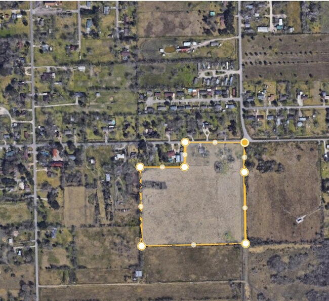
Property Record
316 Phillips Rd, Angleton, TX 77515

Property Detail
316 Phillips Rd
Houston-Pasadena-The Woodlands, TX
A0134 E WALLER BLOCK 5 TRACT 10-10A (SD E/2) ACRES 17.0
0134-0358-000
BRAZORIA
Agriculturalland
Texas
0438
10
B and X Area of moderate flood hazard, usually the area between the limits of the 100-year and 500-year floods.
17 AC
2024
South Hwy 35
2025
Houston
662100
NEARBY LISTINGS FOR SALE OR LEASE
DEMOGRAPHICS near 316 Phillips Rd
1 mile
3 mile
5 mile
2025 Total Population
2,940
15,255
33,275
2030 Population
3,288
16,963
36,987
Pop Growth 2025-2030
+ 11.84%
+ 11.20%
+ 11.16%
Average Age
38
38
38
2025 Total Households
1,010
5,468
11,937
HH Growth 2025-2030
+ 12.18%
+ 11.49%
+ 11.64%
Median Household Inc
$95,152
$89,291
$87,632
Avg Household Size
2.90
2.70
2.70
2025 Avg HH Vehicles
2.00
2.00
2.00
Median Home Value
$229,365
$187,956
$231,508
Median Year Built
1987
1977
1984
Nearby Places
Map Layers
Map Styles
 Street
 Aerial
Transit
 Traffic
 Biking
Places
Listings with unknown addresses are not visible on the map
- Restaurants
- Banks
- Shops
- Fitness
- Groceries
SALE & LEASE HISTORY
LISTING DATE
SALE/LEASE

Nov 08, 2024
For Sale
Nearby Properties
Address
Land Use
TOTAL SIZE
Lot Size
Zoning
Address
Land Use
TOTAL SIZE
Lot Size
Zoning
305,581 SF
8.28 AC
Address
Land Use
TOTAL SIZE
Lot Size
Zoning
318,545 SF
50.52 AC
Address
Land Use
TOTAL SIZE
Lot Size
Zoning
92,290 SF
6.17 AC
0361
Address
Land Use
TOTAL SIZE
Lot Size
Zoning
12,221 SF
13.76 AC
0165
Address
Land Use
TOTAL SIZE
Lot Size
Zoning
266,816 SF
20.34 AC
Address
Land Use
TOTAL SIZE
Lot Size
Zoning
116,629 SF
44.43 AC
Address
Land Use
TOTAL SIZE
Lot Size
Zoning
96,487 SF
1 AC
0011
Address
Land Use
TOTAL SIZE
Lot Size
Zoning
6.52 AC
Address
Land Use
TOTAL SIZE
Lot Size
Zoning
4.60 AC
Address
Land Use
TOTAL SIZE
Lot Size
Zoning
60.29 AC
0068
Address
Land Use
TOTAL SIZE
Lot Size
Zoning
18,091 SF
29.61 AC
Address
Land Use
TOTAL SIZE
Lot Size
Zoning
77,295 SF
6.63 AC
0056
Address
Land Use
TOTAL SIZE
Lot Size
Zoning
90,957 SF
5 AC
Address
Land Use
TOTAL SIZE
Lot Size
Zoning
17,007 SF
13.60 AC
0021
Address
Land Use
TOTAL SIZE
Lot Size
Zoning
1,930 SF
30 AC
0436
Address
Land Use
TOTAL SIZE
Lot Size
Zoning
33,546 SF
13.28 AC
Address
Land Use
TOTAL SIZE
Lot Size
Zoning
112,149 SF
35.71 AC
Address
Land Use
TOTAL SIZE
Lot Size
Zoning
14.52 AC
Address
Land Use
TOTAL SIZE
Lot Size
Zoning
34,125 SF
1.67 AC
Address
Land Use
TOTAL SIZE
Lot Size
Zoning
57,828 SF
4.36 AC
Address
Land Use
TOTAL SIZE
Lot Size
Zoning
20,171 SF
35 AC
Address
Land Use
TOTAL SIZE
Lot Size
Zoning
52,544 SF
4.87 AC
0256
Address
Land Use
TOTAL SIZE
Lot Size
Zoning
19.16 AC
0008
Address
Land Use
TOTAL SIZE
Lot Size
Zoning
Address
Land Use
TOTAL SIZE
Lot Size
Zoning
13,470 SF
0.68 AC
0066
Address
Land Use
TOTAL SIZE
Lot Size
Zoning
29,670 SF
21.34 AC
0149
Address
Land Use
TOTAL SIZE
Lot Size
Zoning
8.91 AC
Address
Land Use
TOTAL SIZE
Lot Size
Zoning
24,447 SF
0.83 AC
Address
Land Use
TOTAL SIZE
Lot Size
Zoning
26,782 SF
11.74 AC
324A
Address
Land Use
TOTAL SIZE
Lot Size
Zoning
2.41 AC
0057
The World's #1 Commercial Real Estate Marketplace
Connect with us
© 2026 CoStar Group
The information above has been obtained from sources believed reliable. While we do not doubt its accuracy we have not verified it and make no guarantee, warranty or representation about it. It is your responsibility to independently confirm its accuracy and completeness. Any projections, opinions, assumptions, or estimates used are for example only and do not represent the current or future performance of the property. The value of this transaction to you depends on tax and other factors which should be evaluated by your tax, financial, and legal advisors. You and your advisors should conduct a careful, independent investigation of the property to determine to your satisfaction the suitability of the property for your needs.