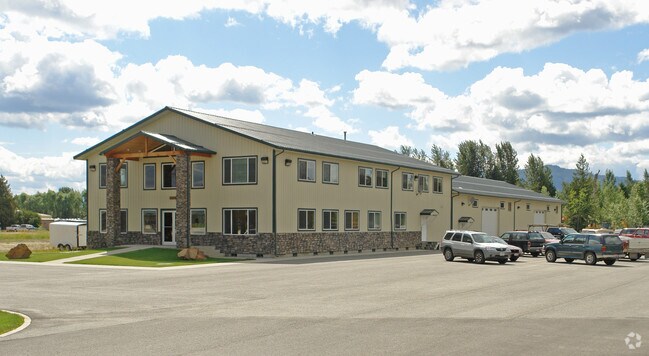
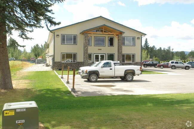
Property Record
31656 Highway 200, Ponderay, ID 83852

Property Detail
31656 Highway 200
RPP00-000-110102A
11-57N-2W TAX 19 LESS TAX 102 & 125
Commercialnec
Bonner
B and X Area of moderate flood hazard, usually the area between the limits of the 100-year and 500-year floods.
Idaho
2025
3.08 AC
2025
Bonner
950203
Coeur D'Alene
13,850 SF
Sandpoint, ID
NEARBY LISTINGS FOR SALE OR LEASE
-
-
View all Ponderay listings for sale on LoopNet.com
DEMOGRAPHICS near 31656 Highway 200
1 mile
3 mile
5 mile
2025 Total Population
3,405
12,668
19,293
2030 Population
3,816
14,068
21,384
Pop Growth 2025-2030
+ 12.07%
+ 11.05%
+ 10.84%
Average Age
41
42
43
2025 Total Households
1,356
5,352
8,076
HH Growth 2025-2030
+ 11.65%
+ 10.63%
+ 10.49%
Median Household Inc
$69,316
$67,587
$70,645
Avg Household Size
2.50
2.30
2.30
2025 Avg HH Vehicles
2.00
2.00
2.00
Median Home Value
$412,654
$453,733
$498,039
Median Year Built
2001
1992
1992
Nearby Places
Map Layers
Map Styles
 Street
 Aerial
Transit
 Traffic
 Biking
Places
Listings with unknown addresses are not visible on the map
- Restaurants
- Banks
- Shops
- Fitness
- Groceries
PUBLIC TRANSPORTATION
COMMUTER RAIL
Drive
Walk
Distance
6 min
2.9 mi
Nearby Properties
Address
Land Use
TOTAL SIZE
Lot Size
Zoning
Address
Land Use
TOTAL SIZE
Lot Size
Zoning
54,573 SF
0.75 AC
Address
Land Use
TOTAL SIZE
Lot Size
Zoning
24,639 SF
3 AC
Address
Land Use
TOTAL SIZE
Lot Size
Zoning
66,673 SF
3.17 AC
Address
Land Use
TOTAL SIZE
Lot Size
Zoning
86,100 SF
1.79 AC
Address
Land Use
TOTAL SIZE
Lot Size
Zoning
49,500 SF
16.53 AC
Address
Land Use
TOTAL SIZE
Lot Size
Zoning
Address
Land Use
TOTAL SIZE
Lot Size
Zoning
4,413 SF
4.79 AC
Address
Land Use
TOTAL SIZE
Lot Size
Zoning
4,512 SF
3.90 AC
Address
Land Use
TOTAL SIZE
Lot Size
Zoning
155,334 SF
11.97 AC
Address
Land Use
TOTAL SIZE
Lot Size
Zoning
156,891 SF
14.84 AC
Address
Land Use
TOTAL SIZE
Lot Size
Zoning
29,154 SF
3.80 AC
Address
Land Use
TOTAL SIZE
Lot Size
Zoning
92,969 SF
15.72 AC
Address
Land Use
TOTAL SIZE
Lot Size
Zoning
82,053 SF
5.26 AC
Address
Land Use
TOTAL SIZE
Lot Size
Zoning
35,708 SF
2.47 AC
Address
Land Use
TOTAL SIZE
Lot Size
Zoning
57,611 SF
2.37 AC
Address
Land Use
TOTAL SIZE
Lot Size
Zoning
53,580 SF
5.63 AC
Address
Land Use
TOTAL SIZE
Lot Size
Zoning
106,375 SF
11.87 AC
Address
Land Use
TOTAL SIZE
Lot Size
Zoning
38,980 SF
2.71 AC
Address
Land Use
TOTAL SIZE
Lot Size
Zoning
88,699 SF
6.93 AC
Address
Land Use
TOTAL SIZE
Lot Size
Zoning
32,130 SF
4.33 AC
Address
Land Use
TOTAL SIZE
Lot Size
Zoning
16,000 SF
2.32 AC
Address
Land Use
TOTAL SIZE
Lot Size
Zoning
20,396 SF
1.40 AC
Address
Land Use
TOTAL SIZE
Lot Size
Zoning
29,910 SF
2.96 AC
Address
Land Use
TOTAL SIZE
Lot Size
Zoning
33,287 SF
8.05 AC
Address
Land Use
TOTAL SIZE
Lot Size
Zoning
0.83 AC
Address
Land Use
TOTAL SIZE
Lot Size
Zoning
26,966 SF
2.69 AC
Address
Land Use
TOTAL SIZE
Lot Size
Zoning
92,969 SF
6.74 AC
Address
Land Use
TOTAL SIZE
Lot Size
Zoning
10,176 SF
1.14 AC
Address
Land Use
TOTAL SIZE
Lot Size
Zoning
10,176 SF
1.06 AC
Address
Land Use
TOTAL SIZE
Lot Size
Zoning
41,930 SF
9.63 AC
S
The World's #1 Commercial Real Estate Marketplace
Connect with us
© 2026 CoStar Group
The information above has been obtained from sources believed reliable. While we do not doubt its accuracy we have not verified it and make no guarantee, warranty or representation about it. It is your responsibility to independently confirm its accuracy and completeness. Any projections, opinions, assumptions, or estimates used are for example only and do not represent the current or future performance of the property. The value of this transaction to you depends on tax and other factors which should be evaluated by your tax, financial, and legal advisors. You and your advisors should conduct a careful, independent investigation of the property to determine to your satisfaction the suitability of the property for your needs.