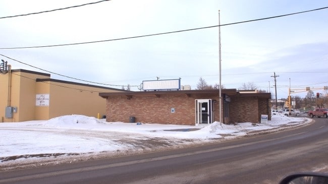
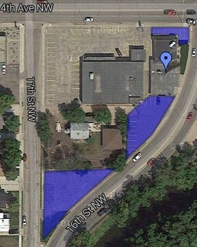
Property Record
317 16Th St Nw, Minot, ND 58703

NEARBY LISTINGS FOR SALE OR LEASE
Property Detail
317 16Th St Nw
Other Market Areas
Souris
Minot, ND
SUB: MI22382 SOURIS ADDITION LOT 1 BLOCK 1
MI-22382-010-001-1
Ward
Realpropertynec
North Dakota
2024
1
2024
0.19 AC
010400
Souris Valley
4,800 SF
DEMOGRAPHICS near 317 16Th St Nw
1 Mile
3 Mile
5 Mile
2024 Total Population
10,847
42,783
51,945
2029 Population
10,608
42,173
51,174
Pop Growth 2024-2029
(2.20%)
(1.43%)
(1.48%)
Average Age
35
38
38
2024 Total Households
4,175
18,574
22,258
HH Growth 2024-2029
(2.44%)
(1.48%)
(1.54%)
Median Household Inc
$78,712
$68,402
$69,007
Avg Household Size
2.40
2.20
2.20
2024 Avg HH Vehicles
2.00
2.00
2.00
Median Home Value
$231,559
$233,548
$236,786
Median Year Built
1972
1981
1983
Nearby Places
Map Layers
Map Styles
 Street
 Aerial
- Restaurants
- Banks
- Shops
- Fitness
- Groceries
PUBLIC TRANSPORTATION
COMMUTER RAIL
DRIVE
WALK
Distance
4 min
1.4 mi
AIRPORT
Minot International
DRIVE
WALK
Distance
Minot International
8 min
3.0 mi
Nearby Properties
Address
Land Use
TOTAL SIZE
Lot Size
Zoning
Address
Land Use
TOTAL SIZE
Lot Size
Zoning
142,655 SF
9.54 AC
Address
Land Use
TOTAL SIZE
Lot Size
Zoning
55,908 SF
5.89 AC
Address
Land Use
TOTAL SIZE
Lot Size
Zoning
121,307 SF
2.97 AC
Address
Land Use
TOTAL SIZE
Lot Size
Zoning
29,172 SF
9.19 AC
Address
Land Use
TOTAL SIZE
Lot Size
Zoning
41,710 SF
2.45 AC
Address
Land Use
TOTAL SIZE
Lot Size
Zoning
14,400 SF
4.46 AC
Address
Land Use
TOTAL SIZE
Lot Size
Zoning
39,667 SF
0.02 AC
Address
Land Use
TOTAL SIZE
Lot Size
Zoning
13.96 AC
Address
Land Use
TOTAL SIZE
Lot Size
Zoning
45,052 SF
3.78 AC
Address
Land Use
TOTAL SIZE
Lot Size
Zoning
46,496 SF
2.41 AC
Address
Land Use
TOTAL SIZE
Lot Size
Zoning
47,150 SF
6.43 AC
Address
Land Use
TOTAL SIZE
Lot Size
Zoning
24,471 SF
1.54 AC
Address
Land Use
TOTAL SIZE
Lot Size
Zoning
31,924 SF
2.82 AC
Address
Land Use
TOTAL SIZE
Lot Size
Zoning
9.49 AC
Address
Land Use
TOTAL SIZE
Lot Size
Zoning
55,520 SF
2.50 AC
Address
Land Use
TOTAL SIZE
Lot Size
Zoning
8,060 SF
1.02 AC
Address
Land Use
TOTAL SIZE
Lot Size
Zoning
6,868 SF
1.52 AC
Address
Land Use
TOTAL SIZE
Lot Size
Zoning
14,112 SF
1.71 AC
Address
Land Use
TOTAL SIZE
Lot Size
Zoning
36,633 SF
2.07 AC
Address
Land Use
TOTAL SIZE
Lot Size
Zoning
38,721 SF
1.60 AC
Address
Land Use
TOTAL SIZE
Lot Size
Zoning
36,158 SF
Address
Land Use
TOTAL SIZE
Lot Size
Zoning
7,200 SF
1.10 AC
Address
Land Use
TOTAL SIZE
Lot Size
Zoning
6,120 SF
0.53 AC
Address
Land Use
TOTAL SIZE
Lot Size
Zoning
9,715 SF
0.86 AC
Address
Land Use
TOTAL SIZE
Lot Size
Zoning
2.63 AC
Address
Land Use
TOTAL SIZE
Lot Size
Zoning
19,520 SF
1.03 AC
The World's #1 Commercial Real Estate Marketplace
Connect with us
© 2026 CoStar Group
The information above has been obtained from sources believed reliable. While we do not doubt its accuracy we have not verified it and make no guarantee, warranty or representation about it. It is your responsibility to independently confirm its accuracy and completeness. Any projections, opinions, assumptions, or estimates used are for example only and do not represent the current or future performance of the property. The value of this transaction to you depends on tax and other factors which should be evaluated by your tax, financial, and legal advisors. You and your advisors should conduct a careful, independent investigation of the property to determine to your satisfaction the suitability of the property for your needs.