Property Record
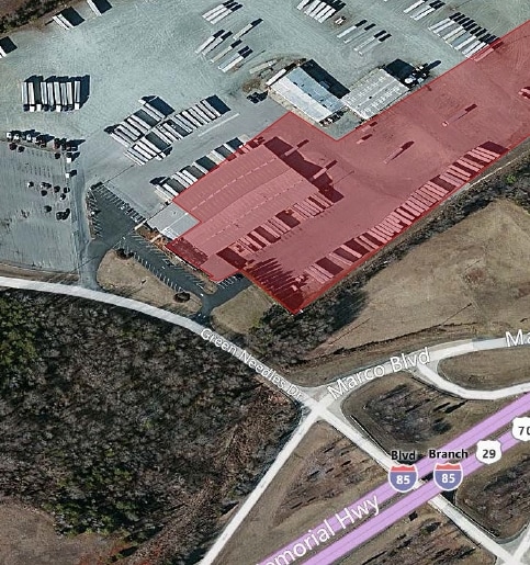
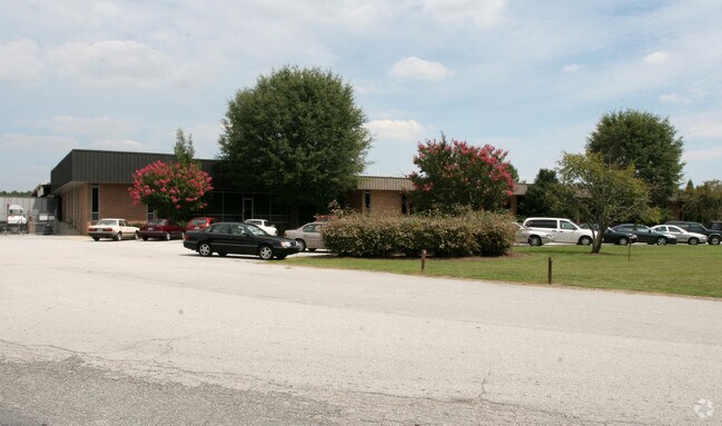
317 Green Needles Dr, Lexington, NC 27295

NEARBY LISTINGS FOR SALE OR LEASE
Property Detail
317 Green Needles Dr
11-345-0-000-0014-A-0-0
Hargrave Heights
Publicstorage
P=11-31 L14A BK1808-1528
X
Davidson
3710671400J
North Carolina
2025
32.25 AC
2025
South Davidson County
061701
Greensboro/Winston-Salem
61,385 SF
Winston-Salem, NC
DEMOGRAPHICS near 317 Green Needles Dr
1 Mile
3 Mile
5 Mile
2024 Total Population
1,711
13,015
39,649
2029 Population
1,806
13,814
42,089
Pop Growth 2024-2029
+ 5.55%
+ 6.14%
+ 6.15%
Average Age
41
40
40
2024 Total Households
720
5,216
15,761
HH Growth 2024-2029
+ 5.42%
+ 6.06%
+ 6.10%
Median Household Inc
$51,818
$41,403
$40,628
Avg Household Size
2.30
2.40
2.40
2024 Avg HH Vehicles
2.00
2.00
2.00
Median Home Value
$157,923
$138,346
$153,563
Median Year Built
1983
1982
1979
Nearby Places
Map Layers
Map Styles
 Street
 Aerial
- Restaurants
- Banks
- Shops
- Fitness
- Groceries
PUBLIC TRANSPORTATION
AIRPORT
Piedmont Triad International
DRIVE
WALK
Distance
Piedmont Triad International
54 min
35.9 mi
Freight Ports
Port of Wilmington
DRIVE
WALK
Distance
Port of Wilmington
262 min
218.3 mi
SALE & LEASE HISTORY
LISTING DATE
SALE/LEASE

Apr 25, 2018
For Lease
Apr 03, 2017
For Lease
Nearby Properties
Address
Land Use
TOTAL SIZE
Lot Size
Zoning
Address
Land Use
TOTAL SIZE
Lot Size
Zoning
187,540 SF
26.94 AC
PD
Address
Land Use
TOTAL SIZE
Lot Size
Zoning
943,340 SF
202.76 AC
RA1
Address
Land Use
TOTAL SIZE
Lot Size
Zoning
22,560 SF
204.19 AC
I
Address
Land Use
TOTAL SIZE
Lot Size
Zoning
3,600 SF
198.35 AC
EC
Address
Land Use
TOTAL SIZE
Lot Size
Zoning
223,743 SF
99.83 AC
I
Address
Land Use
TOTAL SIZE
Lot Size
Zoning
3,156 SF
332.28 AC
HI
Address
Land Use
TOTAL SIZE
Lot Size
Zoning
207,185 SF
29.84 AC
B
Address
Land Use
TOTAL SIZE
Lot Size
Zoning
2,821 SF
32.06 AC
TN
Address
Land Use
TOTAL SIZE
Lot Size
Zoning
9,728 SF
40.03 AC
RA1
Address
Land Use
TOTAL SIZE
Lot Size
Zoning
43,008 SF
25.21 AC
B
Address
Land Use
TOTAL SIZE
Lot Size
Zoning
114,109 SF
20.39 AC
I
Address
Land Use
TOTAL SIZE
Lot Size
Zoning
116,842 SF
20.04 AC
I
Address
Land Use
TOTAL SIZE
Lot Size
Zoning
142,700 SF
18.21 AC
B
Address
Land Use
TOTAL SIZE
Lot Size
Zoning
101,475 SF
108.36 AC
I
Address
Land Use
TOTAL SIZE
Lot Size
Zoning
6,000 SF
33.27 AC
HI
Address
Land Use
TOTAL SIZE
Lot Size
Zoning
66,594 SF
6.59 AC
OI
Address
Land Use
TOTAL SIZE
Lot Size
Zoning
68,288 SF
23.30 AC
LI
Address
Land Use
TOTAL SIZE
Lot Size
Zoning
103,720 SF
21.05 AC
I
Address
Land Use
TOTAL SIZE
Lot Size
Zoning
46,562 SF
1.73 AC
B
Address
Land Use
TOTAL SIZE
Lot Size
Zoning
1,160 SF
28.40 AC
TN
Address
Land Use
TOTAL SIZE
Lot Size
Zoning
131,100 SF
17.78 AC
I
Address
Land Use
TOTAL SIZE
Lot Size
Zoning
214,592 SF
20.01 AC
I
Address
Land Use
TOTAL SIZE
Lot Size
Zoning
49,578 SF
7.74 AC
I
Address
Land Use
TOTAL SIZE
Lot Size
Zoning
14,148 SF
3.34 AC
B
Address
Land Use
TOTAL SIZE
Lot Size
Zoning
201,600 SF
9.90 AC
I
Address
Land Use
TOTAL SIZE
Lot Size
Zoning
131,250 SF
14.30 AC
I
Address
Land Use
TOTAL SIZE
Lot Size
Zoning
23,572 SF
36.39 AC
I
Address
Land Use
TOTAL SIZE
Lot Size
Zoning
59,281 SF
4.34 AC
B
Address
Land Use
TOTAL SIZE
Lot Size
Zoning
313,535 SF
107.06 AC
I
Address
Land Use
TOTAL SIZE
Lot Size
Zoning
49,552 SF
3.33 AC
B
The World's #1 Commercial Real Estate Marketplace
Connect with us
© 2025 CoStar Group
The information above has been obtained from sources believed reliable. While we do not doubt its accuracy we have not verified it and make no guarantee, warranty or representation about it. It is your responsibility to independently confirm its accuracy and completeness. Any projections, opinions, assumptions, or estimates used are for example only and do not represent the current or future performance of the property. The value of this transaction to you depends on tax and other factors which should be evaluated by your tax, financial, and legal advisors. You and your advisors should conduct a careful, independent investigation of the property to determine to your satisfaction the suitability of the property for your needs.