Property Record
317 Saint Paul Rd, Easley, SC 29642
NEARBY LISTINGS FOR SALE OR LEASE
Property Detail
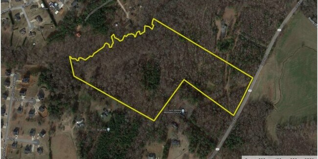
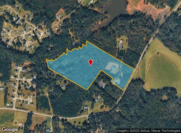
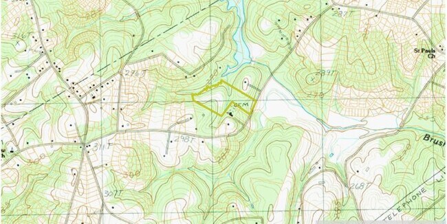
317 Saint Paul Rd
188-00-05-069
CP S 2812/1 PP S 2618/8 F000 D000 PP 049/040 TR B ST PAUL RD 24.34 AC
Agriculturalland
Anderson
X
South Carolina
45007C0041E
24.34 AC
2025
Anderson County
2024
Greenville/Spartanburg
010107
Greenville-Anderson-Greer, SC
DEMOGRAPHICS near 317 Saint Paul Rd
1 mile
3 mile
5 mile
2024 Total Population
1,895
21,617
56,789
2029 Population
2,007
22,712
59,814
Pop Growth 2024-2029
+ 5.91%
+ 5.07%
+ 5.33%
Average Age
40
41
40
2024 Total Households
685
8,118
22,179
HH Growth 2024-2029
+ 5.84%
+ 5.05%
+ 5.37%
Median Household Inc
$90,664
$72,835
$65,488
Avg Household Size
2.70
2.60
2.50
2024 Avg HH Vehicles
2.00
2.00
2.00
Median Home Value
$216,541
$240,412
$220,785
Median Year Built
1997
1993
1991
Nearby Places
Map Layers
Map Styles
 Street
 Aerial
Transit
 Traffic
 Biking
Places
Listings with unknown addresses are not visible on the map
- Restaurants
- Banks
- Shops
- Fitness
- Groceries
PUBLIC TRANSPORTATION
AIRPORT
Greenville Spartanburg International
Drive
Walk
Distance
Greenville Spartanburg International
41 min
25.7 mi
Freight Ports
North Charleston Terminal
Drive
Walk
Distance
North Charleston Terminal
245 min
212.1 mi
SALE & LEASE HISTORY
LISTING DATE
SALE/LEASE

Mar 24, 2021
For Sale
Nearby Properties
Address
Land Use
TOTAL SIZE
Lot Size
Zoning
Address
Land Use
TOTAL SIZE
Lot Size
Zoning
162.06 AC
R10
Address
Land Use
TOTAL SIZE
Lot Size
Zoning
177,695 SF
20.43 AC
Address
Land Use
TOTAL SIZE
Lot Size
Zoning
33,217 SF
5.11 AC
OFFICE INS
Address
Land Use
TOTAL SIZE
Lot Size
Zoning
2,644 SF
0.54 AC
R 10 ONE F
Address
Land Use
TOTAL SIZE
Lot Size
Zoning
42.26 AC
OFFICE INS
Address
Land Use
TOTAL SIZE
Lot Size
Zoning
2,571 SF
0.63 AC
R 10 ONE F
Address
Land Use
TOTAL SIZE
Lot Size
Zoning
2,098 SF
0.23 AC
R10
Address
Land Use
TOTAL SIZE
Lot Size
Zoning
3.98 AC
NEIGHBORHO
Address
Land Use
TOTAL SIZE
Lot Size
Zoning
2,208 SF
1.32 AC
R 10 ONE F
Address
Land Use
TOTAL SIZE
Lot Size
Zoning
3,034 SF
0.47 AC
R 10 ONE F
Address
Land Use
TOTAL SIZE
Lot Size
Zoning
4,084 SF
0.46 AC
R 10 ONE F
Address
Land Use
TOTAL SIZE
Lot Size
Zoning
55 AC
R 10 ONE F
Address
Land Use
TOTAL SIZE
Lot Size
Zoning
16,290 SF
4.68 AC
Address
Land Use
TOTAL SIZE
Lot Size
Zoning
2,350 SF
1.30 AC
R 10 ONE F
Address
Land Use
TOTAL SIZE
Lot Size
Zoning
1,882 SF
0.16 AC
R 6 ONE FA
Address
Land Use
TOTAL SIZE
Lot Size
Zoning
2,756 SF
2.78 AC
R 10 ONE F
Address
Land Use
TOTAL SIZE
Lot Size
Zoning
4,460 SF
0.45 AC
R 10 ONE F
Address
Land Use
TOTAL SIZE
Lot Size
Zoning
1,683 SF
0.79 AC
R 10 ONE F
Address
Land Use
TOTAL SIZE
Lot Size
Zoning
4,655 SF
0.32 AC
R
Address
Land Use
TOTAL SIZE
Lot Size
Zoning
7.06 AC
Address
Land Use
TOTAL SIZE
Lot Size
Zoning
1,904 SF
17.74 AC
R10
Address
Land Use
TOTAL SIZE
Lot Size
Zoning
2,528 SF
0.36 AC
R10
Address
Land Use
TOTAL SIZE
Lot Size
Zoning
2,370 SF
0.50 AC
R 10 ONE F
Address
Land Use
TOTAL SIZE
Lot Size
Zoning
4,605 SF
0.32 AC
R10
Address
Land Use
TOTAL SIZE
Lot Size
Zoning
2,796 SF
0.39 AC
R 10 ONE F
Address
Land Use
TOTAL SIZE
Lot Size
Zoning
2,380 SF
0.40 AC
R 10 ONE F
Address
Land Use
TOTAL SIZE
Lot Size
Zoning
2,180 SF
0.41 AC
R 10 ONE F
Address
Land Use
TOTAL SIZE
Lot Size
Zoning
2,105 SF
0.15 AC
GR2
Address
Land Use
TOTAL SIZE
Lot Size
Zoning
8.03 AC
IND
Address
Land Use
TOTAL SIZE
Lot Size
Zoning
2,219 SF
0.48 AC
R 10 ONE F
The World's #1 Commercial Real Estate Marketplace
Connect with us
© 2026 CoStar Group
The information above has been obtained from sources believed reliable. While we do not doubt its accuracy we have not verified it and make no guarantee, warranty or representation about it. It is your responsibility to independently confirm its accuracy and completeness. Any projections, opinions, assumptions, or estimates used are for example only and do not represent the current or future performance of the property. The value of this transaction to you depends on tax and other factors which should be evaluated by your tax, financial, and legal advisors. You and your advisors should conduct a careful, independent investigation of the property to determine to your satisfaction the suitability of the property for your needs.