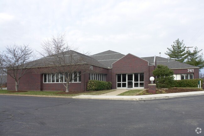
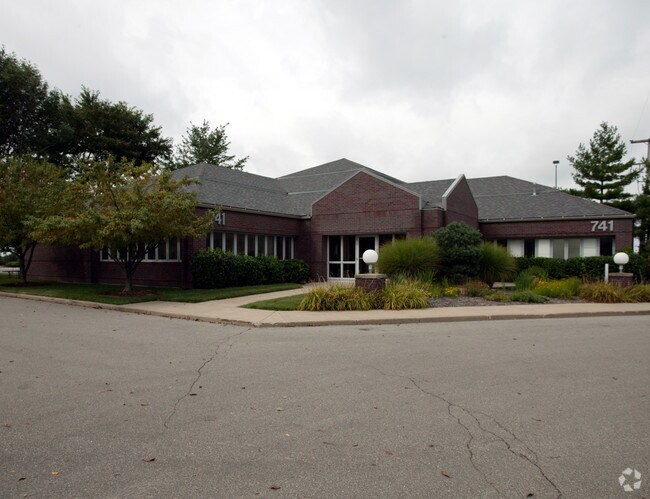
Property Record
3170 Bradford St Ne, Grand Rapids, MI 49525
NEARBY LISTINGS FOR SALE OR LEASE
Property Detail
3170 Bradford St Ne
41-14-22-400-051
PART SE 1/4 COM 176.04 FT S 0D 10M 45S E ALONG E SEC LINE & 277.01 FT N 89D 37M 34S W FROM E 1/4 COR TH N 0D 10M 45S W TO E&W
Officebuilding
Kent
X
Michigan
26081C0427D
0.69 AC
2024
Northeast Grand Rapids
2025
West Michigan
011801
Grand Rapids-Wyoming, MI
5,507 SF
DEMOGRAPHICS near 3170 Bradford St Ne
1 Mile
3 Mile
5 Mile
2024 Total Population
3,227
59,232
198,934
2029 Population
3,252
59,611
200,254
Pop Growth 2024-2029
+ 0.77%
+ 0.64%
+ 0.66%
Average Age
38
39
37
2024 Total Households
1,131
22,855
79,639
HH Growth 2024-2029
+ 0.88%
+ 0.61%
+ 0.70%
Median Household Inc
$122,313
$87,582
$70,719
Avg Household Size
2.40
2.40
2.40
2024 Avg HH Vehicles
2.00
2.00
2.00
Median Home Value
$456,147
$304,626
$256,677
Median Year Built
1986
1964
1959
Nearby Places
Map Layers
Map Styles
 Street
 Aerial
- Restaurants
- Banks
- Shops
- Fitness
- Groceries
PUBLIC TRANSPORTATION
COMMUTER RAIL
DRIVE
WALK
Distance
9 min
6.2 mi
AIRPORT
Gerald R Ford International
DRIVE
WALK
Distance
Gerald R Ford International
19 min
11.1 mi
Nearby Properties
Address
Land Use
TOTAL SIZE
Lot Size
Zoning
Address
Land Use
TOTAL SIZE
Lot Size
Zoning
709,488 SF
106.95 AC
LI
Address
Land Use
TOTAL SIZE
Lot Size
Zoning
126,805 SF
9.36 AC
C4
Address
Land Use
TOTAL SIZE
Lot Size
Zoning
151,708 SF
7.22 AC
C4
Address
Land Use
TOTAL SIZE
Lot Size
Zoning
Address
Land Use
TOTAL SIZE
Lot Size
Zoning
250,170 SF
16.13 AC
R-1
Address
Land Use
TOTAL SIZE
Lot Size
Zoning
211,760 SF
TN-CC
Address
Land Use
TOTAL SIZE
Lot Size
Zoning
257,381 SF
7.08 AC
SD-PRD
Address
Land Use
TOTAL SIZE
Lot Size
Zoning
112,764 SF
17.29 AC
SD-PRD
Address
Land Use
TOTAL SIZE
Lot Size
Zoning
18.07 AC
MON-LDR
Address
Land Use
TOTAL SIZE
Lot Size
Zoning
47,370 SF
8.18 AC
MON-LDR
Address
Land Use
TOTAL SIZE
Lot Size
Zoning
138,278 SF
35.63 AC
R-1
Address
Land Use
TOTAL SIZE
Lot Size
Zoning
18.65 AC
MCN-MDR
Address
Land Use
TOTAL SIZE
Lot Size
Zoning
154,643 SF
10.96 AC
O-PUD
Address
Land Use
TOTAL SIZE
Lot Size
Zoning
24.96 AC
MCN-MDR
Address
Land Use
TOTAL SIZE
Lot Size
Zoning
247,954 SF
40.84 AC
SD-PRD
Address
Land Use
TOTAL SIZE
Lot Size
Zoning
183,583 SF
9.12 AC
R-1
Address
Land Use
TOTAL SIZE
Lot Size
Zoning
158,449 SF
14.33 AC
MCN-MDR
Address
Land Use
TOTAL SIZE
Lot Size
Zoning
158,883 SF
16.53 AC
MCN-LDR
Address
Land Use
TOTAL SIZE
Lot Size
Zoning
21.10 AC
MON-MDR
Address
Land Use
TOTAL SIZE
Lot Size
Zoning
159,721 SF
5.51 AC
C-1
Address
Land Use
TOTAL SIZE
Lot Size
Zoning
105,029 SF
5.65 AC
C
Address
Land Use
TOTAL SIZE
Lot Size
Zoning
417,625 SF
29.60 AC
SD-IT
Address
Land Use
TOTAL SIZE
Lot Size
Zoning
145,127 SF
18.52 AC
SD-PRD
Address
Land Use
TOTAL SIZE
Lot Size
Zoning
22.63 AC
MCN-MDR
Address
Land Use
TOTAL SIZE
Lot Size
Zoning
11.01 AC
MCN-LDR
Address
Land Use
TOTAL SIZE
Lot Size
Zoning
34,120 SF
5.81 AC
SD-PRD
Address
Land Use
TOTAL SIZE
Lot Size
Zoning
56,095 SF
3.30 AC
SD-PRD
Address
Land Use
TOTAL SIZE
Lot Size
Zoning
86,082 SF
171.94 AC
R-1
Address
Land Use
TOTAL SIZE
Lot Size
Zoning
375,083 SF
17.63 AC
SD-IT
Address
Land Use
TOTAL SIZE
Lot Size
Zoning
16.29 AC
MCN-MDR
The World's #1 Commercial Real Estate Marketplace
Connect with us
© 2025 CoStar Group
The information above has been obtained from sources believed reliable. While we do not doubt its accuracy we have not verified it and make no guarantee, warranty or representation about it. It is your responsibility to independently confirm its accuracy and completeness. Any projections, opinions, assumptions, or estimates used are for example only and do not represent the current or future performance of the property. The value of this transaction to you depends on tax and other factors which should be evaluated by your tax, financial, and legal advisors. You and your advisors should conduct a careful, independent investigation of the property to determine to your satisfaction the suitability of the property for your needs.