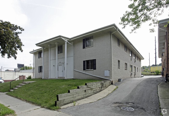
Property Record
3170 S Brust Ave, Milwaukee, WI 53207

NEARBY LISTINGS FOR SALE OR LEASE
Property Detail
3170 S Brust Ave
540-9990-200-3
LANDS IN NW 1/4 SEC 15-6-22 COM E LI S BRUST AVE & 477 S OF N LI OF SD 1/4 SEC-TH E PAR TO S LI W OKLAHOMA AVE 220.15 TO WLY ROW LI OF C&NW RR-TH S 5DEG 52MIN 40SEC W ALG SD ROW LI 14.41-TH S 25DEG 54MIN W 157.33-TH S 41DEG 45MIN W 79.87-TH W AT RT A
Apartment
Milwaukee
X
Wisconsin
55079C0157E
0.85 AC
2024
Bay View
2024
Milwaukee/Madison
020700
Milwaukee-Waukesha, WI
27,384 SF
DEMOGRAPHICS near 3170 S Brust Ave
1 Mile
3 Mile
5 Mile
2024 Total Population
17,729
106,370
273,553
2029 Population
17,302
103,730
267,335
Pop Growth 2024-2029
(2.41%)
(2.48%)
(2.27%)
Average Age
41
37
37
2024 Total Households
8,734
43,140
117,290
HH Growth 2024-2029
(2.48%)
(2.52%)
(2.16%)
Median Household Inc
$75,283
$54,054
$52,726
Avg Household Size
2.00
2.40
2.20
2024 Avg HH Vehicles
2.00
2.00
1.00
Median Home Value
$234,733
$175,801
$183,506
Median Year Built
1947
1948
1952
Nearby Places
Map Layers
Map Styles
 Street
 Aerial
- Restaurants
- Banks
- Shops
- Fitness
- Groceries
PUBLIC TRANSPORTATION
COMMUTER RAIL
Milwaukee (Empire Builder - Amtrak)
DRIVE
WALK
Distance
Milwaukee (Empire Builder - Amtrak)
9 min
4.7 mi
General Mitchell Intl. Airport Amtrak Station (Hiawatha Service - Amtrak)
DRIVE
WALK
Distance
General Mitchell Intl. Airport Amtrak Station (Hiawatha Service - Amtrak)
12 min
5.5 mi
AIRPORT
General Mitchell International
DRIVE
WALK
Distance
General Mitchell International
11 min
4.9 mi
Freight Ports
Port Milwaukee
DRIVE
WALK
Distance
Port Milwaukee
5 min
1.8 mi
Nearby Properties
Address
Land Use
TOTAL SIZE
Lot Size
Zoning
Address
Land Use
TOTAL SIZE
Lot Size
Zoning
41.05 AC
IO2
Address
Land Use
TOTAL SIZE
Lot Size
Zoning
319,559 SF
6.29 AC
PD
Address
Land Use
TOTAL SIZE
Lot Size
Zoning
179 AC
IH
Address
Land Use
TOTAL SIZE
Lot Size
Zoning
Address
Land Use
TOTAL SIZE
Lot Size
Zoning
11.09 AC
Address
Land Use
TOTAL SIZE
Lot Size
Zoning
204,809 SF
1.04 AC
IM
Address
Land Use
TOTAL SIZE
Lot Size
Zoning
12.02 AC
IO2
Address
Land Use
TOTAL SIZE
Lot Size
Zoning
48.34 AC
IO1
Address
Land Use
TOTAL SIZE
Lot Size
Zoning
2,610 SF
1.04 AC
IM
Address
Land Use
TOTAL SIZE
Lot Size
Zoning
86.13 AC
IH
Address
Land Use
TOTAL SIZE
Lot Size
Zoning
11.38 AC
TL
Address
Land Use
TOTAL SIZE
Lot Size
Zoning
120,000 SF
1.10 AC
IM
Address
Land Use
TOTAL SIZE
Lot Size
Zoning
222,100 SF
1.29 AC
PD
Address
Land Use
TOTAL SIZE
Lot Size
Zoning
197,354 SF
18 AC
CS
Address
Land Use
TOTAL SIZE
Lot Size
Zoning
0.43 AC
RT3
Address
Land Use
TOTAL SIZE
Lot Size
Zoning
183,291 SF
11.48 AC
IM
Address
Land Use
TOTAL SIZE
Lot Size
Zoning
Address
Land Use
TOTAL SIZE
Lot Size
Zoning
122,602 SF
0.89 AC
IM
Address
Land Use
TOTAL SIZE
Lot Size
Zoning
83,827 SF
2.07 AC
PD
Address
Land Use
TOTAL SIZE
Lot Size
Zoning
76.97 AC
IH
Address
Land Use
TOTAL SIZE
Lot Size
Zoning
360,000 SF
14.60 AC
IL1
Address
Land Use
TOTAL SIZE
Lot Size
Zoning
20.49 AC
TL
Address
Land Use
TOTAL SIZE
Lot Size
Zoning
94.05 AC
PK
Address
Land Use
TOTAL SIZE
Lot Size
Zoning
153,300 SF
7.39 AC
M-1PUD
Address
Land Use
TOTAL SIZE
Lot Size
Zoning
Address
Land Use
TOTAL SIZE
Lot Size
Zoning
Address
Land Use
TOTAL SIZE
Lot Size
Zoning
999,999 SF
4.66 AC
IL2
Address
Land Use
TOTAL SIZE
Lot Size
Zoning
66,300 SF
3.95 AC
LB1
Address
Land Use
TOTAL SIZE
Lot Size
Zoning
108,471 SF
0.54 AC
PD
Address
Land Use
TOTAL SIZE
Lot Size
Zoning
91,454 SF
0.46 AC
PD
The World's #1 Commercial Real Estate Marketplace
Connect with us
© 2026 CoStar Group
The information above has been obtained from sources believed reliable. While we do not doubt its accuracy we have not verified it and make no guarantee, warranty or representation about it. It is your responsibility to independently confirm its accuracy and completeness. Any projections, opinions, assumptions, or estimates used are for example only and do not represent the current or future performance of the property. The value of this transaction to you depends on tax and other factors which should be evaluated by your tax, financial, and legal advisors. You and your advisors should conduct a careful, independent investigation of the property to determine to your satisfaction the suitability of the property for your needs.