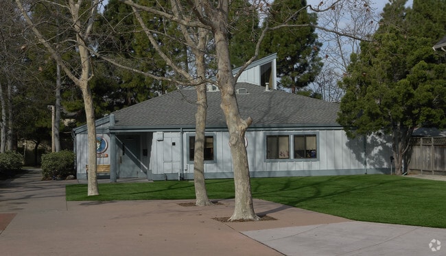
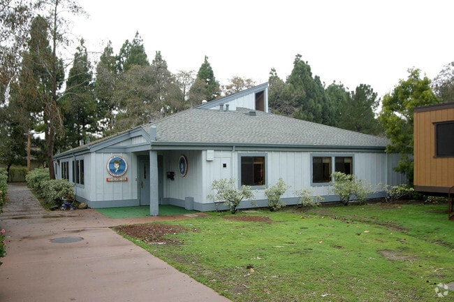
Property Record
3171 Mecartney Rd, Alameda, CA 94502


Save to a Folder
{{folder.Name}}
{{folder.ListingIds.length}} Properties
{{folder.ListingIds.length}} Property
Create a New Folder
Property Detail
3171 Mecartney Rd
Oakland-Fremont-Berkeley, CA
LOT: 00004 BLK: PM: 0111 PAGE: 0010
074-1045-014-00
Alameda
Publicschool
California
AE The base floodplain where base flood elevations are provided. AE Zones are now used on new format FIRMs instead of A1-A30 Zones.
5
2024
0.23 AC
2025
Alameda
428302
East Bay/Oakland
4,769 SF
NEARBY LISTINGS FOR SALE OR LEASE
DEMOGRAPHICS near 3171 Mecartney Rd
1 mile
3 mile
5 mile
2025 Total Population
14,097
80,962
369,035
2030 Population
14,073
80,805
368,821
Pop Growth 2025-2030
(0.17%)
(0.19%)
(0.06%)
Average Age
45
42
40
2025 Total Households
5,024
29,518
132,337
HH Growth 2025-2030
(0.30%)
(0.24%)
+ 0.04%
Median Household Inc
$181,428
$115,486
$90,228
Avg Household Size
2.70
2.60
2.60
2025 Avg HH Vehicles
2.00
2.00
2.00
Median Home Value
$1,083,398
$1,058,681
$860,749
Median Year Built
1983
1962
1955
Nearby Places
Map Layers
Map Styles
 Street
 Aerial
Layers
 Traffic
 Biking
Places
Listings with unknown addresses are not visible on the map
- Restaurants
- Banks
- Shops
- Fitness
- Groceries
PUBLIC TRANSPORTATION
COMMUTER RAIL
Drive
Walk
Distance
14 min
6.6 mi
AIRPORT
Metro Oakland International
Drive
Walk
Distance
Metro Oakland International
6 min
2.1 mi
San Francisco International
Drive
Walk
Distance
San Francisco International
45 min
33.1 mi
Norman Y Mineta San Jose International
Drive
Walk
Distance
Norman Y Mineta San Jose International
49 min
37.6 mi
Freight Ports
Port of Oakland
Drive
Walk
Distance
Port of Oakland
15 min
7.1 mi
SALE & LEASE HISTORY
LISTING DATE
SALE/LEASE

Nov 14, 2024
For Sale
Nearby Properties
Address
Land Use
TOTAL SIZE
Lot Size
Zoning
Address
Land Use
TOTAL SIZE
Lot Size
Zoning
Address
Land Use
TOTAL SIZE
Lot Size
Zoning
546,164 SF
6.02 AC
Address
Land Use
TOTAL SIZE
Lot Size
Zoning
427,980 SF
39.96 AC
Address
Land Use
TOTAL SIZE
Lot Size
Zoning
219,200 SF
5.49 AC
Address
Land Use
TOTAL SIZE
Lot Size
Zoning
371,504 SF
4.08 AC
Address
Land Use
TOTAL SIZE
Lot Size
Zoning
534,208 SF
23.18 AC
Address
Land Use
TOTAL SIZE
Lot Size
Zoning
259,247 SF
5.44 AC
R5PD
Address
Land Use
TOTAL SIZE
Lot Size
Zoning
165,923 SF
14.99 AC
Address
Land Use
TOTAL SIZE
Lot Size
Zoning
190,786 SF
3.75 AC
Address
Land Use
TOTAL SIZE
Lot Size
Zoning
128,650 SF
6.38 AC
Address
Land Use
TOTAL SIZE
Lot Size
Zoning
180,959 SF
9.38 AC
Address
Land Use
TOTAL SIZE
Lot Size
Zoning
374,725 SF
18.63 AC
Address
Land Use
TOTAL SIZE
Lot Size
Zoning
336,680 SF
9.93 AC
M40
Address
Land Use
TOTAL SIZE
Lot Size
Zoning
284,255 SF
5.07 AC
Address
Land Use
TOTAL SIZE
Lot Size
Zoning
165,042 SF
13.50 AC
Address
Land Use
TOTAL SIZE
Lot Size
Zoning
200,238 SF
9.28 AC
Address
Land Use
TOTAL SIZE
Lot Size
Zoning
133,678 SF
4.33 AC
Address
Land Use
TOTAL SIZE
Lot Size
Zoning
138,196 SF
8.47 AC
Address
Land Use
TOTAL SIZE
Lot Size
Zoning
155,000 SF
8.41 AC
Address
Land Use
TOTAL SIZE
Lot Size
Zoning
136,127 SF
8.21 AC
Address
Land Use
TOTAL SIZE
Lot Size
Zoning
232,068 SF
31.82 AC
Address
Land Use
TOTAL SIZE
Lot Size
Zoning
93,964 SF
24.21 AC
Address
Land Use
TOTAL SIZE
Lot Size
Zoning
76,114 SF
6 AC
Address
Land Use
TOTAL SIZE
Lot Size
Zoning
197,321 SF
16.52 AC
Address
Land Use
TOTAL SIZE
Lot Size
Zoning
213,600 SF
10.60 AC
Address
Land Use
TOTAL SIZE
Lot Size
Zoning
1,189,534 SF
26.64 AC
Address
Land Use
TOTAL SIZE
Lot Size
Zoning
100,909 SF
6.70 AC
Address
Land Use
TOTAL SIZE
Lot Size
Zoning
121,597 SF
5.75 AC
Address
Land Use
TOTAL SIZE
Lot Size
Zoning
204,006 SF
6.39 AC
M40
Address
Land Use
TOTAL SIZE
Lot Size
Zoning
80,810 SF
5.62 AC
The World's #1 Commercial Real Estate Marketplace
Connect with us
© 2026 CoStar Group
The information above has been obtained from sources believed reliable. While we do not doubt its accuracy we have not verified it and make no guarantee, warranty or representation about it. It is your responsibility to independently confirm its accuracy and completeness. Any projections, opinions, assumptions, or estimates used are for example only and do not represent the current or future performance of the property. The value of this transaction to you depends on tax and other factors which should be evaluated by your tax, financial, and legal advisors. You and your advisors should conduct a careful, independent investigation of the property to determine to your satisfaction the suitability of the property for your needs.