Property Record
3172 E Main Rd, Dunkirk, NY 14048


Property Detail
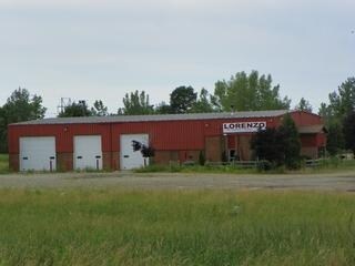
3172 E Main Rd
Jamestown-Dunkirk, NY
OLD APN: 066400 5-1-6.5.2.2
066400-097-000-0001-031-000
Chautauqua
Truckterminal
New York
07 - MIXED
31.000
2025
5 AC
2024
New York West Area
035300
Other Market Areas
6,710 SF
NEARBY LISTINGS FOR SALE OR LEASE
-
-
View all Dunkirk listings for sale on LoopNet.com
DEMOGRAPHICS near 3172 E Main Rd
1 mile
3 mile
5 mile
2025 Total Population
276
5,719
27,577
2030 Population
264
5,463
27,374
Pop Growth 2025-2030
(4.35%)
(4.48%)
(0.74%)
Average Age
47
42
41
2025 Total Households
112
2,441
11,468
HH Growth 2025-2030
(4.46%)
(4.75%)
(0.68%)
Median Household Inc
$85,227
$55,361
$53,794
Avg Household Size
2.40
2.30
2.20
2025 Avg HH Vehicles
2.00
1.00
2.00
Median Home Value
$182,499
$102,160
$131,368
Median Year Built
1955
1952
1955
Nearby Places
Map Layers
Map Styles
 Street
 Aerial
Transit
 Traffic
 Biking
Places
Listings with unknown addresses are not visible on the map
- Restaurants
- Banks
- Shops
- Fitness
- Groceries
PUBLIC TRANSPORTATION
AIRPORT
Buffalo Niagara International
Drive
Walk
Distance
Buffalo Niagara International
68 min
48.8 mi
Nearby Properties
Address
Land Use
TOTAL SIZE
Lot Size
Zoning
Address
Land Use
TOTAL SIZE
Lot Size
Zoning
163,219 SF
6.50 AC
M2
Address
Land Use
TOTAL SIZE
Lot Size
Zoning
1,300 SF
16 AC
M1
Address
Land Use
TOTAL SIZE
Lot Size
Zoning
542,989 SF
47.40 AC
L1
Address
Land Use
TOTAL SIZE
Lot Size
Zoning
113,097 SF
8.20 AC
HC
Address
Land Use
TOTAL SIZE
Lot Size
Zoning
31.20 AC
C1
Address
Land Use
TOTAL SIZE
Lot Size
Zoning
93,000 SF
14 AC
Address
Land Use
TOTAL SIZE
Lot Size
Zoning
90,660 SF
5.30 AC
HC
Address
Land Use
TOTAL SIZE
Lot Size
Zoning
21,000 SF
11.70 AC
HC
Address
Land Use
TOTAL SIZE
Lot Size
Zoning
228,261 SF
10.50 AC
L1
Address
Land Use
TOTAL SIZE
Lot Size
Zoning
33,826 SF
3.10 AC
R3
Address
Land Use
TOTAL SIZE
Lot Size
Zoning
30,882 SF
10.58 AC
M2
Address
Land Use
TOTAL SIZE
Lot Size
Zoning
31,715 SF
3.20 AC
CR
Address
Land Use
TOTAL SIZE
Lot Size
Zoning
20.60 AC
CR
Address
Land Use
TOTAL SIZE
Lot Size
Zoning
18,914 SF
7.35 AC
M2
Address
Land Use
TOTAL SIZE
Lot Size
Zoning
190,873 SF
21.50 AC
V1
Address
Land Use
TOTAL SIZE
Lot Size
Zoning
1.70 AC
Address
Land Use
TOTAL SIZE
Lot Size
Zoning
23,810 SF
256.60 AC
07 - MIXED
Address
Land Use
TOTAL SIZE
Lot Size
Zoning
65,201 SF
7.20 AC
HC
Address
Land Use
TOTAL SIZE
Lot Size
Zoning
121,500 SF
9.30 AC
06 - INDUS
Address
Land Use
TOTAL SIZE
Lot Size
Zoning
27,238 SF
1.60 AC
C1
Address
Land Use
TOTAL SIZE
Lot Size
Zoning
30,205 SF
4.18 AC
R3
Address
Land Use
TOTAL SIZE
Lot Size
Zoning
29,747 SF
3.90 AC
CR
Address
Land Use
TOTAL SIZE
Lot Size
Zoning
32,467 SF
1.16 AC
R2
Address
Land Use
TOTAL SIZE
Lot Size
Zoning
164,015 SF
9.10 AC
M2
Address
Land Use
TOTAL SIZE
Lot Size
Zoning
121,450 SF
9.60 AC
05 - COMME
Address
Land Use
TOTAL SIZE
Lot Size
Zoning
8,120 SF
3.30 AC
R3
Address
Land Use
TOTAL SIZE
Lot Size
Zoning
79.90 AC
07 - MIXED
Address
Land Use
TOTAL SIZE
Lot Size
Zoning
21,015 SF
1.63 AC
R2
Address
Land Use
TOTAL SIZE
Lot Size
Zoning
51,455 SF
5.40 AC
HC
Address
Land Use
TOTAL SIZE
Lot Size
Zoning
76.20 AC
07 - MIXED
The World's #1 Commercial Real Estate Marketplace
Connect with us
© 2026 CoStar Group
The information above has been obtained from sources believed reliable. While we do not doubt its accuracy we have not verified it and make no guarantee, warranty or representation about it. It is your responsibility to independently confirm its accuracy and completeness. Any projections, opinions, assumptions, or estimates used are for example only and do not represent the current or future performance of the property. The value of this transaction to you depends on tax and other factors which should be evaluated by your tax, financial, and legal advisors. You and your advisors should conduct a careful, independent investigation of the property to determine to your satisfaction the suitability of the property for your needs.