Property Record
31770 State Highway 75, Oneonta, AL 35121
NEARBY LISTINGS FOR SALE OR LEASE
-
-
View all Oneonta listings for sale on LoopNet.com
Property Detail
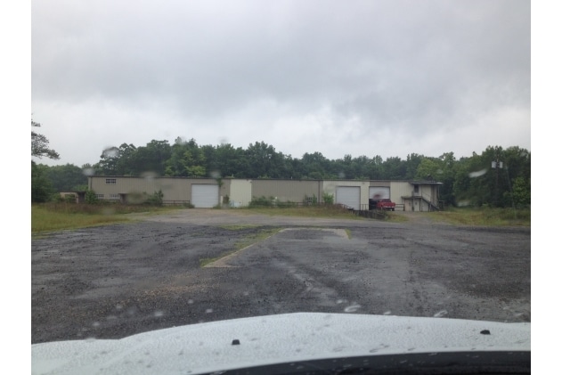
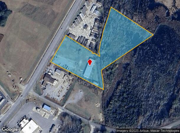
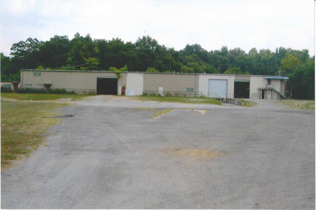
31770 State Highway 75
16-05-21-0-000-004.000
COM SW COR NW/SW NLY 768 TO S R/W ST HWY 75 NE ALG R/W 225 TO POB CONT NE ALG R/W 347 SE 416 TO CENTER OF CREEK NLY ALG CREEK
Distributionwarehouseregional
Blount
A
Alabama
01009C0330F
8.70 AC
2025
Blount County
2024
Birmingham
050105
Birmingham, AL
12,000 SF
DEMOGRAPHICS near 31770 State Highway 75
1 mile
3 mile
5 mile
2024 Total Population
593
6,488
11,244
2029 Population
600
6,563
11,360
Pop Growth 2024-2029
+ 1.18%
+ 1.16%
+ 1.03%
Average Age
44
42
41
2024 Total Households
221
2,451
4,235
HH Growth 2024-2029
+ 1.36%
+ 1.14%
+ 1.02%
Median Household Inc
$34,062
$46,176
$45,272
Avg Household Size
2.40
2.50
2.50
2024 Avg HH Vehicles
2.00
2.00
2.00
Median Home Value
$217,778
$201,762
$171,963
Median Year Built
1973
1972
1976
Nearby Places
Map Layers
Map Styles
 Street
 Aerial
Transit
 Traffic
 Biking
Places
Listings with unknown addresses are not visible on the map
- Restaurants
- Banks
- Shops
- Fitness
- Groceries
PUBLIC TRANSPORTATION
AIRPORT
Birmingham-Shuttlesworth International
Drive
Walk
Distance
Birmingham-Shuttlesworth International
60 min
37.2 mi
SALE & LEASE HISTORY
LISTING DATE
SALE/LEASE

Sep 23, 2016
For Sale
Mar 23, 2017
For Sale
Nearby Properties
Address
Land Use
TOTAL SIZE
Lot Size
Zoning
Address
Land Use
TOTAL SIZE
Lot Size
Zoning
147,374 SF
11 AC
Address
Land Use
TOTAL SIZE
Lot Size
Zoning
42,799 SF
6.10 AC
Address
Land Use
TOTAL SIZE
Lot Size
Zoning
27,944 SF
1.08 AC
Address
Land Use
TOTAL SIZE
Lot Size
Zoning
32,392 SF
1.34 AC
Address
Land Use
TOTAL SIZE
Lot Size
Zoning
24,872 SF
24 AC
Address
Land Use
TOTAL SIZE
Lot Size
Zoning
23,245 SF
0.99 AC
Address
Land Use
TOTAL SIZE
Lot Size
Zoning
15,626 SF
0.36 AC
Address
Land Use
TOTAL SIZE
Lot Size
Zoning
99,004 SF
18 AC
Address
Land Use
TOTAL SIZE
Lot Size
Zoning
6,418 SF
8.10 AC
Address
Land Use
TOTAL SIZE
Lot Size
Zoning
45,000 SF
7.20 AC
Address
Land Use
TOTAL SIZE
Lot Size
Zoning
18,592 SF
0.50 AC
Address
Land Use
TOTAL SIZE
Lot Size
Zoning
8,970 SF
0.65 AC
Address
Land Use
TOTAL SIZE
Lot Size
Zoning
11,921 SF
6.70 AC
Address
Land Use
TOTAL SIZE
Lot Size
Zoning
10,000 SF
1.02 AC
Address
Land Use
TOTAL SIZE
Lot Size
Zoning
9,238 SF
1.71 AC
Address
Land Use
TOTAL SIZE
Lot Size
Zoning
15,928 SF
0.96 AC
Address
Land Use
TOTAL SIZE
Lot Size
Zoning
20,930 SF
2.30 AC
Address
Land Use
TOTAL SIZE
Lot Size
Zoning
38,561 SF
3 AC
Address
Land Use
TOTAL SIZE
Lot Size
Zoning
14,560 SF
4 AC
Address
Land Use
TOTAL SIZE
Lot Size
Zoning
49,700 SF
6.90 AC
Address
Land Use
TOTAL SIZE
Lot Size
Zoning
10,004 SF
1.09 AC
Address
Land Use
TOTAL SIZE
Lot Size
Zoning
19,602 SF
4.70 AC
Address
Land Use
TOTAL SIZE
Lot Size
Zoning
10,343 SF
9 AC
Address
Land Use
TOTAL SIZE
Lot Size
Zoning
14,800 SF
2.98 AC
Address
Land Use
TOTAL SIZE
Lot Size
Zoning
15,855 SF
1.22 AC
Address
Land Use
TOTAL SIZE
Lot Size
Zoning
10,841 SF
0.40 AC
Address
Land Use
TOTAL SIZE
Lot Size
Zoning
4,560 SF
0.90 AC
Address
Land Use
TOTAL SIZE
Lot Size
Zoning
11,040 SF
0.70 AC
The World's #1 Commercial Real Estate Marketplace
Connect with us
© 2026 CoStar Group
The information above has been obtained from sources believed reliable. While we do not doubt its accuracy we have not verified it and make no guarantee, warranty or representation about it. It is your responsibility to independently confirm its accuracy and completeness. Any projections, opinions, assumptions, or estimates used are for example only and do not represent the current or future performance of the property. The value of this transaction to you depends on tax and other factors which should be evaluated by your tax, financial, and legal advisors. You and your advisors should conduct a careful, independent investigation of the property to determine to your satisfaction the suitability of the property for your needs.