Property Record
3177 Solomons Island Rd, Edgewater, MD 21037


Save to a Folder
{{folder.Name}}
{{folder.ListingIds.length}} Properties
{{folder.ListingIds.length}} Property
Create a New Folder
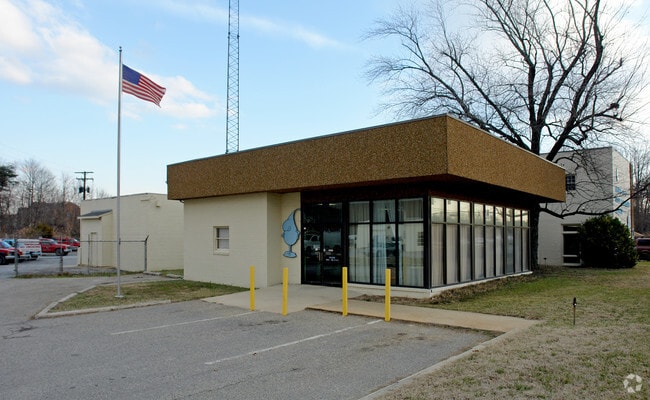
Property Detail
3177 Solomons Island Rd
01-000-06168002
LT APP 200X200 ARUNDEL GAS
Loftbuilding
Anne Arundel
C4
Maryland
B and X Area of moderate flood hazard, usually the area between the limits of the 100-year and 500-year floods.
0.92 AC
2024
Southern Anne Arundel
2025
Baltimore
701104
Baltimore-Columbia-Towson, MD
8,653 SF
NEARBY LISTINGS FOR SALE OR LEASE
-
-
View all Edgewater listings for sale on LoopNet.com
DEMOGRAPHICS near 3177 Solomons Island Rd
1 mile
3 mile
5 mile
2025 Total Population
7,187
27,505
93,209
2030 Population
7,227
27,905
94,688
Pop Growth 2025-2030
+ 0.56%
+ 1.45%
+ 1.59%
Average Age
42
44
43
2025 Total Households
2,748
10,685
37,794
HH Growth 2025-2030
+ 0.51%
+ 1.54%
+ 1.61%
Median Household Inc
$111,840
$138,911
$117,430
Avg Household Size
2.50
2.50
2.40
2025 Avg HH Vehicles
2.00
2.00
2.00
Median Home Value
$460,489
$599,256
$584,234
Median Year Built
1980
1985
1982
Nearby Places
Map Layers
Map Styles
 Street
 Aerial
Layers
 Traffic
 Biking
Places
Listings with unknown addresses are not visible on the map
- Restaurants
- Banks
- Shops
- Fitness
- Groceries
PUBLIC TRANSPORTATION
AIRPORT
Baltimore/Washington International Thurgood Marshall
Drive
Walk
Distance
Baltimore/Washington International Thurgood Marshall
36 min
25.0 mi
Ronald Reagan Washington Ntl
Drive
Walk
Distance
Ronald Reagan Washington Ntl
53 min
34.2 mi
Freight Ports
Port of Baltimore
Drive
Walk
Distance
Port of Baltimore
42 min
30.2 mi
Nearby Properties
Address
Land Use
TOTAL SIZE
Lot Size
Zoning
Address
Land Use
TOTAL SIZE
Lot Size
Zoning
441,482 SF
3.85 AC
W1
Address
Land Use
TOTAL SIZE
Lot Size
Zoning
365,268 SF
4.85 AC
W1
Address
Land Use
TOTAL SIZE
Lot Size
Zoning
589,210 SF
111.38 AC
RA
Address
Land Use
TOTAL SIZE
Lot Size
Zoning
285,174 SF
24 AC
R2
Address
Land Use
TOTAL SIZE
Lot Size
Zoning
73.33 AC
R2
Address
Land Use
TOTAL SIZE
Lot Size
Zoning
91.22 AC
C2
Address
Land Use
TOTAL SIZE
Lot Size
Zoning
138,592 SF
8.47 AC
W1
Address
Land Use
TOTAL SIZE
Lot Size
Zoning
134,693 SF
6 AC
R2
Address
Land Use
TOTAL SIZE
Lot Size
Zoning
124,626 SF
4.73 AC
C2
Address
Land Use
TOTAL SIZE
Lot Size
Zoning
9.15 AC
C2
Address
Land Use
TOTAL SIZE
Lot Size
Zoning
117,008 SF
1.40 AC
C4
Address
Land Use
TOTAL SIZE
Lot Size
Zoning
149,300 SF
2.93 AC
C2
Address
Land Use
TOTAL SIZE
Lot Size
Zoning
132,000 SF
5.55 AC
W1B
Address
Land Use
TOTAL SIZE
Lot Size
Zoning
82,022 SF
50.50 AC
RA
Address
Land Use
TOTAL SIZE
Lot Size
Zoning
112,662 SF
14.44 AC
C3
Address
Land Use
TOTAL SIZE
Lot Size
Zoning
77,261 SF
3.56 AC
C3
Address
Land Use
TOTAL SIZE
Lot Size
Zoning
94,932 SF
9.52 AC
C4
Address
Land Use
TOTAL SIZE
Lot Size
Zoning
77,280 SF
7.52 AC
C2
Address
Land Use
TOTAL SIZE
Lot Size
Zoning
65,836 SF
10.73 AC
R2
Address
Land Use
TOTAL SIZE
Lot Size
Zoning
71,934 SF
8.34 AC
W1
Address
Land Use
TOTAL SIZE
Lot Size
Zoning
63,558 SF
0.43 AC
C2
Address
Land Use
TOTAL SIZE
Lot Size
Zoning
63,558 SF
0.43 AC
C2
Address
Land Use
TOTAL SIZE
Lot Size
Zoning
63,558 SF
0.43 AC
C2
Address
Land Use
TOTAL SIZE
Lot Size
Zoning
63,558 SF
0.43 AC
C2
Address
Land Use
TOTAL SIZE
Lot Size
Zoning
61,141 SF
5.05 AC
C3
Address
Land Use
TOTAL SIZE
Lot Size
Zoning
66,108 SF
3.78 AC
W1
Address
Land Use
TOTAL SIZE
Lot Size
Zoning
54,600 SF
8.18 AC
W1A
Address
Land Use
TOTAL SIZE
Lot Size
Zoning
72,031 SF
2.38 AC
C2
Address
Land Use
TOTAL SIZE
Lot Size
Zoning
41,817 SF
15.53 AC
R1
Address
Land Use
TOTAL SIZE
Lot Size
Zoning
95,316 SF
4.36 AC
W1B
The World's #1 Commercial Real Estate Marketplace
Connect with us
© 2026 CoStar Group
The information above has been obtained from sources believed reliable. While we do not doubt its accuracy we have not verified it and make no guarantee, warranty or representation about it. It is your responsibility to independently confirm its accuracy and completeness. Any projections, opinions, assumptions, or estimates used are for example only and do not represent the current or future performance of the property. The value of this transaction to you depends on tax and other factors which should be evaluated by your tax, financial, and legal advisors. You and your advisors should conduct a careful, independent investigation of the property to determine to your satisfaction the suitability of the property for your needs.