Property Record
318 S Scientific St, High Point, NC 27260
NEARBY LISTINGS FOR SALE OR LEASE
-
-
View all High Point listings for sale on LoopNet.com
Property Detail
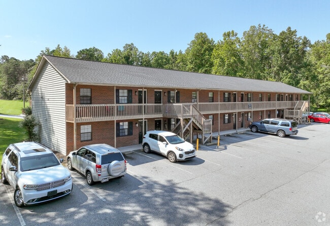
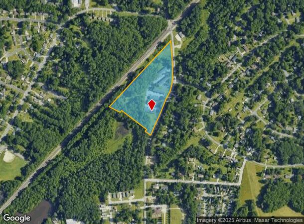
318 S Scientific St
Greensboro-High Point, NC
Scientific St
0182230
10.75 AC SCIENTIFIC ST
Apartment
Guilford
AE
North Carolina
3710781100J
5
2024
10.75 AC
2025
Greater High Point
014503
Greensboro/Winston-Salem
38,400 SF
DEMOGRAPHICS near 318 S Scientific St
1 mile
3 mile
5 mile
2024 Total Population
6,669
46,165
118,737
2029 Population
6,672
46,345
118,980
Pop Growth 2024-2029
+ 0.04%
+ 0.39%
+ 0.20%
Average Age
40
38
40
2024 Total Households
2,567
16,692
46,910
HH Growth 2024-2029
+ 0.04%
+ 0.44%
+ 0.20%
Median Household Inc
$65,829
$43,953
$57,952
Avg Household Size
2.60
2.40
2.40
2024 Avg HH Vehicles
2.00
2.00
2.00
Median Home Value
$128,937
$151,028
$184,458
Median Year Built
1980
1976
1982
Nearby Places
Map Layers
Map Styles
 Street
 Aerial
Transit
 Traffic
 Biking
Places
Listings with unknown addresses are not visible on the map
- Restaurants
- Banks
- Shops
- Fitness
- Groceries
PUBLIC TRANSPORTATION
COMMUTER RAIL
High Point Station (Piedmont - North Carolina by Train (NC Train))
Drive
Walk
Distance
High Point Station (Piedmont - North Carolina by Train (NC Train))
8 min
4.2 mi
AIRPORT
Piedmont Triad International
Drive
Walk
Distance
Piedmont Triad International
25 min
11.5 mi
Freight Ports
Port of Wilmington
Drive
Walk
Distance
Port of Wilmington
252 min
213.1 mi
Nearby Properties
Address
Land Use
TOTAL SIZE
Lot Size
Zoning
Address
Land Use
TOTAL SIZE
Lot Size
Zoning
264,860 SF
62.75 AC
PI
Address
Land Use
TOTAL SIZE
Lot Size
Zoning
464,134 SF
11.28 AC
PI
Address
Land Use
TOTAL SIZE
Lot Size
Zoning
236,597 SF
13.83 AC
CU-PI
Address
Land Use
TOTAL SIZE
Lot Size
Zoning
419,281 SF
25.12 AC
CIV
Address
Land Use
TOTAL SIZE
Lot Size
Zoning
805,958 SF
61.42 AC
LI
Address
Land Use
TOTAL SIZE
Lot Size
Zoning
1,259,149 SF
46.12 AC
HB
Address
Land Use
TOTAL SIZE
Lot Size
Zoning
136,202 SF
30.02 AC
CZ-I
Address
Land Use
TOTAL SIZE
Lot Size
Zoning
231,597 SF
8.46 AC
PD-R
Address
Land Use
TOTAL SIZE
Lot Size
Zoning
30,322 SF
964.25 AC
PNR
Address
Land Use
TOTAL SIZE
Lot Size
Zoning
142,800 SF
1.04 AC
CB
Address
Land Use
TOTAL SIZE
Lot Size
Zoning
285,094 SF
3.23 AC
CB
Address
Land Use
TOTAL SIZE
Lot Size
Zoning
118,290 SF
8.28 AC
CZ-I
Address
Land Use
TOTAL SIZE
Lot Size
Zoning
299,349 SF
21.76 AC
RM-16
Address
Land Use
TOTAL SIZE
Lot Size
Zoning
403,590 SF
72.06 AC
CIV
Address
Land Use
TOTAL SIZE
Lot Size
Zoning
185,320 SF
15.08 AC
PI
Address
Land Use
TOTAL SIZE
Lot Size
Zoning
90,060 SF
3.15 AC
CZ-I
Address
Land Use
TOTAL SIZE
Lot Size
Zoning
250,573 SF
48.53 AC
R-5
Address
Land Use
TOTAL SIZE
Lot Size
Zoning
324,986 SF
24.19 AC
LI
Address
Land Use
TOTAL SIZE
Lot Size
Zoning
473,040 SF
63.60 AC
AG
Address
Land Use
TOTAL SIZE
Lot Size
Zoning
181,106 SF
16.23 AC
RM-16
Address
Land Use
TOTAL SIZE
Lot Size
Zoning
145,571 SF
11.01 AC
RC
Address
Land Use
TOTAL SIZE
Lot Size
Zoning
157,695 SF
73.84 AC
CU-PDR
Address
Land Use
TOTAL SIZE
Lot Size
Zoning
72,851 SF
9.13 AC
IND
Address
Land Use
TOTAL SIZE
Lot Size
Zoning
113,866 SF
11.53 AC
LI
Address
Land Use
TOTAL SIZE
Lot Size
Zoning
101,625 SF
4.97 AC
CZ-I
Address
Land Use
TOTAL SIZE
Lot Size
Zoning
79,740 SF
24.38 AC
R-5
Address
Land Use
TOTAL SIZE
Lot Size
Zoning
127,040 SF
7.41 AC
RM-26
Address
Land Use
TOTAL SIZE
Lot Size
Zoning
79,022 SF
6.52 AC
CIV
Address
Land Use
TOTAL SIZE
Lot Size
Zoning
13,772 SF
167.15 AC
CIV
Address
Land Use
TOTAL SIZE
Lot Size
Zoning
54,648 SF
3.79 AC
CB
The World's #1 Commercial Real Estate Marketplace
Connect with us
© 2026 CoStar Group
The information above has been obtained from sources believed reliable. While we do not doubt its accuracy we have not verified it and make no guarantee, warranty or representation about it. It is your responsibility to independently confirm its accuracy and completeness. Any projections, opinions, assumptions, or estimates used are for example only and do not represent the current or future performance of the property. The value of this transaction to you depends on tax and other factors which should be evaluated by your tax, financial, and legal advisors. You and your advisors should conduct a careful, independent investigation of the property to determine to your satisfaction the suitability of the property for your needs.