Property Record
318 W Cooperative Center Dr, Newaygo, MI 49337
NEARBY LISTINGS FOR SALE OR LEASE
-
-
View all Newaygo listings for sale on LoopNet.com
Property Detail
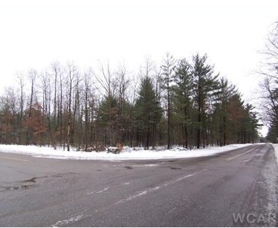
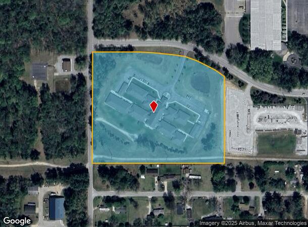
318 W Cooperative Center Dr
Retirementnursinghomecombined
PT NE 1/4 COM S00D10'25W 672.79 FT FR N 1/4 POB, TH N89D37'03E 402.99 FT, TH ALG S RIGHT OF WAY LN SE'LY ALG 490.11
X
Newaygo
26123C0441D
Michigan
2025
10.83 AC
2025
Newaygo County
971200
West Michigan
46,611 SF
18-25-200-037
DEMOGRAPHICS near 318 W Cooperative Center Dr
1 Mile
3 Mile
5 Mile
2024 Total Population
1,587
6,139
11,297
2029 Population
1,656
6,487
11,930
Pop Growth 2024-2029
+ 4.35%
+ 5.67%
+ 5.60%
Average Age
38
40
41
2024 Total Households
590
2,339
4,292
HH Growth 2024-2029
+ 4.24%
+ 5.64%
+ 5.59%
Median Household Inc
$52,692
$58,451
$60,545
Avg Household Size
2.50
2.50
2.50
2024 Avg HH Vehicles
2.00
2.00
2.00
Median Home Value
$163,207
$174,840
$182,822
Median Year Built
1984
1981
1980
Nearby Places
Map Layers
Map Styles
 Street
 Aerial
- Restaurants
- Banks
- Shops
- Fitness
- Groceries
Nearby Properties
Address
Land Use
TOTAL SIZE
Lot Size
Zoning
Address
Land Use
TOTAL SIZE
Lot Size
Zoning
Address
Land Use
TOTAL SIZE
Lot Size
Zoning
54,366 SF
7.70 AC
LOCAL ZONE
Address
Land Use
TOTAL SIZE
Lot Size
Zoning
173,880 SF
27 AC
LOCAL ZONE
Address
Land Use
TOTAL SIZE
Lot Size
Zoning
Address
Land Use
TOTAL SIZE
Lot Size
Zoning
8 AC
LOCAL ZONE
Address
Land Use
TOTAL SIZE
Lot Size
Zoning
114,376 SF
21.20 AC
LOCAL ZONE
Address
Land Use
TOTAL SIZE
Lot Size
Zoning
46,733 SF
6.75 AC
LOCAL ZONE
Address
Land Use
TOTAL SIZE
Lot Size
Zoning
57,044 SF
606.89 AC
LOCAL ZONE
Address
Land Use
TOTAL SIZE
Lot Size
Zoning
9,452 SF
15.95 AC
LOCAL ZONE
Address
Land Use
TOTAL SIZE
Lot Size
Zoning
35,502 SF
3.12 AC
LOCAL ZONE
Address
Land Use
TOTAL SIZE
Lot Size
Zoning
40,636 SF
10 AC
LOCAL ZONE
Address
Land Use
TOTAL SIZE
Lot Size
Zoning
1,200 SF
39.83 AC
LOCAL ZONE
Address
Land Use
TOTAL SIZE
Lot Size
Zoning
6,178 SF
7.49 AC
LOCAL ZONE
Address
Land Use
TOTAL SIZE
Lot Size
Zoning
25,200 SF
3.30 AC
LOCAL ZONE
Address
Land Use
TOTAL SIZE
Lot Size
Zoning
Address
Land Use
TOTAL SIZE
Lot Size
Zoning
67,240 SF
12.80 AC
LOCAL ZONE
Address
Land Use
TOTAL SIZE
Lot Size
Zoning
85,653 SF
5.17 AC
LOCAL ZONE
Address
Land Use
TOTAL SIZE
Lot Size
Zoning
33 AC
LOCAL ZONE
Address
Land Use
TOTAL SIZE
Lot Size
Zoning
15.43 AC
R1
Address
Land Use
TOTAL SIZE
Lot Size
Zoning
3,374 SF
1.19 AC
LOCAL ZONE
Address
Land Use
TOTAL SIZE
Lot Size
Zoning
2,824 SF
0.48 AC
LOCAL ZONE
Address
Land Use
TOTAL SIZE
Lot Size
Zoning
2,455 SF
1.08 AC
LOCAL ZONE
Address
Land Use
TOTAL SIZE
Lot Size
Zoning
28,608 SF
4.37 AC
LOCAL ZONE
Address
Land Use
TOTAL SIZE
Lot Size
Zoning
0.04 AC
LOCAL ZONE
Address
Land Use
TOTAL SIZE
Lot Size
Zoning
2,092 SF
35 AC
LOCAL ZONE
Address
Land Use
TOTAL SIZE
Lot Size
Zoning
3,304 SF
1.01 AC
LOCAL ZONE
Address
Land Use
TOTAL SIZE
Lot Size
Zoning
Address
Land Use
TOTAL SIZE
Lot Size
Zoning
3,052 SF
1.40 AC
LOCAL ZONE
Address
Land Use
TOTAL SIZE
Lot Size
Zoning
8,827 SF
1.82 AC
LOCAL ZONE
The World's #1 Commercial Real Estate Marketplace
Connect with us
© 2026 CoStar Group
The information above has been obtained from sources believed reliable. While we do not doubt its accuracy we have not verified it and make no guarantee, warranty or representation about it. It is your responsibility to independently confirm its accuracy and completeness. Any projections, opinions, assumptions, or estimates used are for example only and do not represent the current or future performance of the property. The value of this transaction to you depends on tax and other factors which should be evaluated by your tax, financial, and legal advisors. You and your advisors should conduct a careful, independent investigation of the property to determine to your satisfaction the suitability of the property for your needs.