Property Record
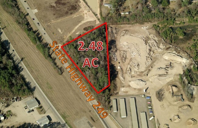
31830 State Highway 249, Pinehurst, TX 77362

Property Detail
31830 State Highway 249
0264-00-07000
A0264 HALE E R, TRACT 70, ACRES 4.313
Commercialnec
MONTGOMERY
AE The base floodplain where base flood elevations are provided. AE Zones are now used on new format FIRMs instead of A1-A30 Zones.
Texas
2024
4.31 AC
2025
Northwest Outlier
690405
Houston
4,679 SF
Houston-Pasadena-The Woodlands, TX
NEARBY LISTINGS FOR SALE OR LEASE
DEMOGRAPHICS near 31830 State Highway 249
1 mile
3 mile
5 mile
2025 Total Population
3,623
23,791
61,068
2030 Population
4,239
27,195
69,848
Pop Growth 2025-2030
+ 17.00%
+ 14.31%
+ 14.38%
Average Age
36
40
39
2025 Total Households
1,215
8,438
21,481
HH Growth 2025-2030
+ 17.53%
+ 14.38%
+ 14.46%
Median Household Inc
$81,915
$101,141
$97,264
Avg Household Size
2.90
2.80
2.80
2025 Avg HH Vehicles
2.00
2.00
2.00
Median Home Value
$285,184
$397,085
$398,613
Median Year Built
2007
2001
2006
Nearby Places
Map Layers
Map Styles
 Street
 Aerial
Layers
 Traffic
 Biking
Places
Listings with unknown addresses are not visible on the map
- Restaurants
- Banks
- Shops
- Fitness
- Groceries
PUBLIC TRANSPORTATION
AIRPORT
George Bush Intcntl/Houston
Drive
Walk
Distance
George Bush Intcntl/Houston
39 min
30.9 mi
Freight Ports
Port of Houston
Drive
Walk
Distance
Port of Houston
59 min
41.6 mi
Nearby Properties
Address
Land Use
TOTAL SIZE
Lot Size
Zoning
Address
Land Use
TOTAL SIZE
Lot Size
Zoning
110,553 SF
10.34 AC
Address
Land Use
TOTAL SIZE
Lot Size
Zoning
176,180 SF
7.28 AC
Address
Land Use
TOTAL SIZE
Lot Size
Zoning
146,990 SF
7.02 AC
Address
Land Use
TOTAL SIZE
Lot Size
Zoning
59,119 SF
6.26 AC
Address
Land Use
TOTAL SIZE
Lot Size
Zoning
112,854 SF
5.80 AC
Address
Land Use
TOTAL SIZE
Lot Size
Zoning
118,004 SF
5.55 AC
Address
Land Use
TOTAL SIZE
Lot Size
Zoning
135,804 SF
15.33 AC
Address
Land Use
TOTAL SIZE
Lot Size
Zoning
65,475 SF
7.84 AC
Address
Land Use
TOTAL SIZE
Lot Size
Zoning
104,859 SF
5.29 AC
Address
Land Use
TOTAL SIZE
Lot Size
Zoning
73,992 SF
7.21 AC
Address
Land Use
TOTAL SIZE
Lot Size
Zoning
122,970 SF
11.79 AC
Address
Land Use
TOTAL SIZE
Lot Size
Zoning
81,277 SF
4.43 AC
Address
Land Use
TOTAL SIZE
Lot Size
Zoning
41,541 SF
3.93 AC
Address
Land Use
TOTAL SIZE
Lot Size
Zoning
24,483 SF
9.66 AC
Address
Land Use
TOTAL SIZE
Lot Size
Zoning
14,865 SF
1.98 AC
2
Address
Land Use
TOTAL SIZE
Lot Size
Zoning
90,311 SF
10 AC
Address
Land Use
TOTAL SIZE
Lot Size
Zoning
7,800 SF
18.47 AC
Address
Land Use
TOTAL SIZE
Lot Size
Zoning
100,389 SF
5.47 AC
2
Address
Land Use
TOTAL SIZE
Lot Size
Zoning
1,184 SF
27.54 AC
Address
Land Use
TOTAL SIZE
Lot Size
Zoning
48,896 SF
2 AC
Address
Land Use
TOTAL SIZE
Lot Size
Zoning
10,946 SF
0.91 AC
Address
Land Use
TOTAL SIZE
Lot Size
Zoning
28,189 SF
2.07 AC
Address
Land Use
TOTAL SIZE
Lot Size
Zoning
12,798 SF
1.18 AC
Address
Land Use
TOTAL SIZE
Lot Size
Zoning
67,125 SF
10.41 AC
Address
Land Use
TOTAL SIZE
Lot Size
Zoning
20,994 SF
1.27 AC
Address
Land Use
TOTAL SIZE
Lot Size
Zoning
1,722 SF
31.19 AC
2
Address
Land Use
TOTAL SIZE
Lot Size
Zoning
25,050 SF
2.16 AC
Address
Land Use
TOTAL SIZE
Lot Size
Zoning
12,276 SF
4.81 AC
Address
Land Use
TOTAL SIZE
Lot Size
Zoning
40.23 AC
Address
Land Use
TOTAL SIZE
Lot Size
Zoning
43,400 SF
6.05 AC
2
The World's #1 Commercial Real Estate Marketplace
Connect with us
© 2026 CoStar Group
The information above has been obtained from sources believed reliable. While we do not doubt its accuracy we have not verified it and make no guarantee, warranty or representation about it. It is your responsibility to independently confirm its accuracy and completeness. Any projections, opinions, assumptions, or estimates used are for example only and do not represent the current or future performance of the property. The value of this transaction to you depends on tax and other factors which should be evaluated by your tax, financial, and legal advisors. You and your advisors should conduct a careful, independent investigation of the property to determine to your satisfaction the suitability of the property for your needs.