Property Record
3188 S Byrne Rd, Toledo, OH 43614
NEARBY LISTINGS FOR SALE OR LEASE
Property Detail
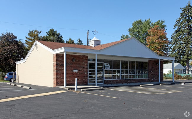
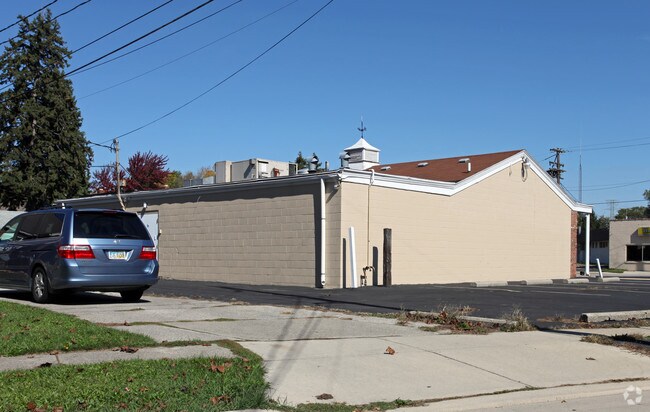
3188 S Byrne Rd
Toledo, OH
Milton Pl First Addn
10-19161
MILTON PL FIRST ADDN LOT 157 EXC PT IN THE RD
Storebuilding
Lucas
X
Ohio
39173C0028D
157
2024
0.14 AC
2024
South/Southwest
004503
Toledo
DEMOGRAPHICS near 3188 S Byrne Rd
1 Mile
3 Mile
5 Mile
2024 Total Population
8,224
63,118
151,937
2029 Population
7,996
62,211
151,123
Pop Growth 2024-2029
(2.77%)
(1.44%)
(0.54%)
Average Age
42
41
39
2024 Total Households
3,642
29,008
65,727
HH Growth 2024-2029
(2.86%)
(1.43%)
(0.61%)
Median Household Inc
$67,943
$58,334
$54,143
Avg Household Size
2.20
2.10
2.20
2024 Avg HH Vehicles
2.00
2.00
2.00
Median Home Value
$148,983
$159,489
$151,226
Median Year Built
1955
1966
1971
Nearby Places
Map Layers
Map Styles
 Street
 Aerial
- Restaurants
- Banks
- Shops
- Fitness
- Groceries
PUBLIC TRANSPORTATION
COMMUTER RAIL
DRIVE
WALK
Distance
9 min
6.2 mi
AIRPORT
Eugene F Kranz Toledo Express
DRIVE
WALK
Distance
Eugene F Kranz Toledo Express
26 min
13.1 mi
Freight Ports
DRIVE
WALK
Distance
23 min
12.3 mi
SALE & LEASE HISTORY
LISTING DATE
SALE/LEASE

Sep 24, 2016
For Lease
Nearby Properties
Address
Land Use
TOTAL SIZE
Lot Size
Zoning
Address
Land Use
TOTAL SIZE
Lot Size
Zoning
1,237,446 SF
193.94 AC
10-RS12
Address
Land Use
TOTAL SIZE
Lot Size
Zoning
598,713 SF
59.75 AC
Address
Land Use
TOTAL SIZE
Lot Size
Zoning
245,237 SF
31.72 AC
10-MX
Address
Land Use
TOTAL SIZE
Lot Size
Zoning
115,872 SF
10.12 AC
Address
Land Use
TOTAL SIZE
Lot Size
Zoning
393,343 SF
62.48 AC
10-IC
Address
Land Use
TOTAL SIZE
Lot Size
Zoning
123,064 SF
10 AC
10-RS6
Address
Land Use
TOTAL SIZE
Lot Size
Zoning
170,960 SF
4 AC
10-RS6
Address
Land Use
TOTAL SIZE
Lot Size
Zoning
3.56 AC
Address
Land Use
TOTAL SIZE
Lot Size
Zoning
184,765 SF
12.91 AC
Address
Land Use
TOTAL SIZE
Lot Size
Zoning
173,528 SF
25.90 AC
Address
Land Use
TOTAL SIZE
Lot Size
Zoning
269,263 SF
55.93 AC
16-R2
Address
Land Use
TOTAL SIZE
Lot Size
Zoning
94,439 SF
9 AC
10-CO
Address
Land Use
TOTAL SIZE
Lot Size
Zoning
316,351 SF
30.65 AC
10-IC
Address
Land Use
TOTAL SIZE
Lot Size
Zoning
138,607 SF
21.30 AC
10-RS12
Address
Land Use
TOTAL SIZE
Lot Size
Zoning
606,883 SF
119.87 AC
16-M2
Address
Land Use
TOTAL SIZE
Lot Size
Zoning
94,891 SF
18.80 AC
10-RS6
Address
Land Use
TOTAL SIZE
Lot Size
Zoning
352,382 SF
62.93 AC
16-M1
Address
Land Use
TOTAL SIZE
Lot Size
Zoning
80,668 SF
9.67 AC
Address
Land Use
TOTAL SIZE
Lot Size
Zoning
100,446 SF
19.44 AC
Address
Land Use
TOTAL SIZE
Lot Size
Zoning
119.87 AC
16-M2
Address
Land Use
TOTAL SIZE
Lot Size
Zoning
81,672 SF
14.93 AC
10-RS9
Address
Land Use
TOTAL SIZE
Lot Size
Zoning
210,996 SF
22.18 AC
10-CRSO
Address
Land Use
TOTAL SIZE
Lot Size
Zoning
181,944 SF
24.55 AC
Address
Land Use
TOTAL SIZE
Lot Size
Zoning
131,201 SF
10 AC
10-CUP
Address
Land Use
TOTAL SIZE
Lot Size
Zoning
69,007 SF
15.93 AC
Address
Land Use
TOTAL SIZE
Lot Size
Zoning
75,770 SF
2.55 AC
Address
Land Use
TOTAL SIZE
Lot Size
Zoning
75,890 SF
19.08 AC
Address
Land Use
TOTAL SIZE
Lot Size
Zoning
363,176 SF
11.72 AC
10-RM36
Address
Land Use
TOTAL SIZE
Lot Size
Zoning
48,321 SF
93.94 AC
10-RS12
Address
Land Use
TOTAL SIZE
Lot Size
Zoning
58.33 AC
10-IL
The World's #1 Commercial Real Estate Marketplace
Connect with us
© 2025 CoStar Group
The information above has been obtained from sources believed reliable. While we do not doubt its accuracy we have not verified it and make no guarantee, warranty or representation about it. It is your responsibility to independently confirm its accuracy and completeness. Any projections, opinions, assumptions, or estimates used are for example only and do not represent the current or future performance of the property. The value of this transaction to you depends on tax and other factors which should be evaluated by your tax, financial, and legal advisors. You and your advisors should conduct a careful, independent investigation of the property to determine to your satisfaction the suitability of the property for your needs.