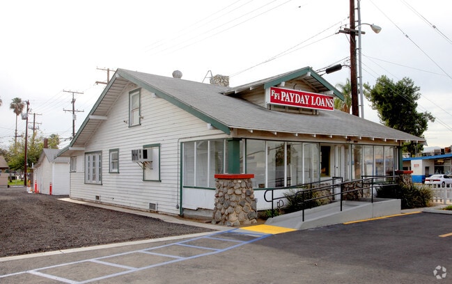
Property Record
9892 Magnolia Ave, Riverside, CA 92503


Property Detail
9892 Magnolia Ave
Riverside-San Bernardino-Ontario, CA
POR LOT 4 MB 006/044 HARRISON PK TR
234-080-010
Riverside
Storebuilding
California
C2
4
B and X Area of moderate flood hazard, usually the area between the limits of the 100-year and 500-year floods.
0.22 AC
2024
Riverside
2025
Inland Empire (California)
031601
NEARBY LISTINGS FOR SALE OR LEASE
DEMOGRAPHICS near 9892 Magnolia Ave
1 mile
3 mile
5 mile
2025 Total Population
19,636
142,071
256,016
2030 Population
20,044
145,065
261,613
Pop Growth 2025-2030
+ 2.08%
+ 2.11%
+ 2.19%
Average Age
36
36
37
2025 Total Households
5,887
40,201
74,222
HH Growth 2025-2030
+ 1.56%
+ 1.64%
+ 1.74%
Median Household Inc
$69,298
$85,554
$94,867
Avg Household Size
3.20
3.30
3.30
2025 Avg HH Vehicles
2.00
2.00
2.00
Median Home Value
$576,779
$615,794
$653,931
Median Year Built
1974
1976
1978
Nearby Places
Map Layers
Map Styles
 Street
 Aerial
Transit
 Traffic
 Biking
Places
Listings with unknown addresses are not visible on the map
- Restaurants
- Banks
- Shops
- Fitness
- Groceries
PUBLIC TRANSPORTATION
COMMUTER RAIL
Riverside-La Sierra (91 Line - Southern California Regional Rail Authority (Metrolink), Inland Empire-Orange County Line - Southern California Regional Rail Authority (Metrolink))
Drive
Walk
Distance
Riverside-La Sierra (91 Line - Southern California Regional Rail Authority (Metrolink), Inland Empire-Orange County Line - Southern California Regional Rail Authority (Metrolink))
5 min
2.6 mi
Pedley (Riverside Line - Southern California Regional Rail Authority (Metrolink))
Drive
Walk
Distance
Pedley (Riverside Line - Southern California Regional Rail Authority (Metrolink))
10 min
5.2 mi
AIRPORT
Ontario International
Drive
Walk
Distance
Ontario International
25 min
15.8 mi
John Wayne/Orange County
Drive
Walk
Distance
John Wayne/Orange County
44 min
35.3 mi
Freight Ports
Port of Long Beach
Drive
Walk
Distance
Port of Long Beach
65 min
49.3 mi
Nearby Properties
Address
Land Use
TOTAL SIZE
Lot Size
Zoning
Address
Land Use
TOTAL SIZE
Lot Size
Zoning
1,658,755 SF
37.05 AC
Address
Land Use
TOTAL SIZE
Lot Size
Zoning
263,807 SF
13.14 AC
Address
Land Use
TOTAL SIZE
Lot Size
Zoning
167,068 SF
26.55 AC
Address
Land Use
TOTAL SIZE
Lot Size
Zoning
76,546 SF
13.53 AC
R
Address
Land Use
TOTAL SIZE
Lot Size
Zoning
154,680 SF
3.13 AC
R1
Address
Land Use
TOTAL SIZE
Lot Size
Zoning
45,862 SF
5.12 AC
Address
Land Use
TOTAL SIZE
Lot Size
Zoning
20.08 AC
R020
Address
Land Use
TOTAL SIZE
Lot Size
Zoning
32,830 SF
6.66 AC
Address
Land Use
TOTAL SIZE
Lot Size
Zoning
169,980 SF
10.51 AC
C3
Address
Land Use
TOTAL SIZE
Lot Size
Zoning
27,916 SF
8.50 AC
R3
Address
Land Use
TOTAL SIZE
Lot Size
Zoning
43,152 SF
6.76 AC
R3S2
Address
Land Use
TOTAL SIZE
Lot Size
Zoning
46,694 SF
7.16 AC
Address
Land Use
TOTAL SIZE
Lot Size
Zoning
14 AC
R1
Address
Land Use
TOTAL SIZE
Lot Size
Zoning
234,750 SF
13.31 AC
R3150
Address
Land Use
TOTAL SIZE
Lot Size
Zoning
25,808 SF
6.21 AC
Address
Land Use
TOTAL SIZE
Lot Size
Zoning
855,621 SF
46.79 AC
I
Address
Land Use
TOTAL SIZE
Lot Size
Zoning
249,729 SF
15.60 AC
R3
Address
Land Use
TOTAL SIZE
Lot Size
Zoning
179,589 SF
18.62 AC
Address
Land Use
TOTAL SIZE
Lot Size
Zoning
157,112 SF
10.83 AC
Address
Land Use
TOTAL SIZE
Lot Size
Zoning
8.75 AC
R1065
Address
Land Use
TOTAL SIZE
Lot Size
Zoning
14,068 SF
6.61 AC
R3
Address
Land Use
TOTAL SIZE
Lot Size
Zoning
127,770 SF
12.94 AC
Address
Land Use
TOTAL SIZE
Lot Size
Zoning
4,562 SF
6.42 AC
Address
Land Use
TOTAL SIZE
Lot Size
Zoning
129,911 SF
6.10 AC
Address
Land Use
TOTAL SIZE
Lot Size
Zoning
116,787 SF
2.37 AC
Address
Land Use
TOTAL SIZE
Lot Size
Zoning
163,325 SF
6.42 AC
R1
Address
Land Use
TOTAL SIZE
Lot Size
Zoning
483,726 SF
3.47 AC
C2
Address
Land Use
TOTAL SIZE
Lot Size
Zoning
156,599 SF
6.27 AC
Address
Land Use
TOTAL SIZE
Lot Size
Zoning
110,680 SF
11.88 AC
MP
The World's #1 Commercial Real Estate Marketplace
Connect with us
© 2026 CoStar Group
The information above has been obtained from sources believed reliable. While we do not doubt its accuracy we have not verified it and make no guarantee, warranty or representation about it. It is your responsibility to independently confirm its accuracy and completeness. Any projections, opinions, assumptions, or estimates used are for example only and do not represent the current or future performance of the property. The value of this transaction to you depends on tax and other factors which should be evaluated by your tax, financial, and legal advisors. You and your advisors should conduct a careful, independent investigation of the property to determine to your satisfaction the suitability of the property for your needs.