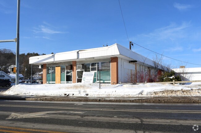
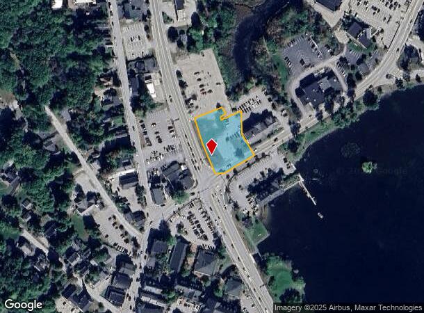
Property Record
319 Daniel Webster Hwy, Meredith, NH 03253
NEARBY LISTINGS FOR SALE OR LEASE
Property Detail
319 Daniel Webster Hwy
Laconia, NH
Belknap
MERE M:00U07 B:0109B
New Hampshire
Officecondo
0.92 AC
2024
Concord/New Hampshire North Area
2024
Other Market Areas
965200
DEMOGRAPHICS near 319 Daniel Webster Hwy
1 mile
3 mile
5 mile
2024 Total Population
1,989
5,737
11,569
2029 Population
2,049
5,992
12,385
Pop Growth 2024-2029
+ 3.02%
+ 4.44%
+ 7.05%
Average Age
47
49
50
2024 Total Households
913
2,500
5,196
HH Growth 2024-2029
+ 2.74%
+ 4.28%
+ 7.08%
Median Household Inc
$37,749
$56,927
$78,418
Avg Household Size
2.10
2.20
2.20
2024 Avg HH Vehicles
2.00
2.00
2.00
Median Home Value
$356,999
$382,867
$392,743
Median Year Built
1979
1978
1981
Nearby Places
Map Layers
Map Styles
 Street
 Aerial
Transit
 Traffic
 Biking
Places
Listings with unknown addresses are not visible on the map
- Restaurants
- Banks
- Shops
- Fitness
- Groceries
Nearby Properties
Address
Land Use
TOTAL SIZE
Lot Size
Zoning
Address
Land Use
TOTAL SIZE
Lot Size
Zoning
61,304 SF
4.02 AC
CB
Address
Land Use
TOTAL SIZE
Lot Size
Zoning
28.20 AC
R
Address
Land Use
TOTAL SIZE
Lot Size
Zoning
11,216 SF
7.01 AC
S
Address
Land Use
TOTAL SIZE
Lot Size
Zoning
100,579 SF
10.16 AC
CS&S
Address
Land Use
TOTAL SIZE
Lot Size
Zoning
8.91 AC
R
Address
Land Use
TOTAL SIZE
Lot Size
Zoning
3.73 AC
CB
Address
Land Use
TOTAL SIZE
Lot Size
Zoning
28.80 AC
CB
Address
Land Use
TOTAL SIZE
Lot Size
Zoning
29,927 SF
5.70 AC
CB
Address
Land Use
TOTAL SIZE
Lot Size
Zoning
5,909 SF
6 AC
S
Address
Land Use
TOTAL SIZE
Lot Size
Zoning
5,460 SF
2.23 AC
S
Address
Land Use
TOTAL SIZE
Lot Size
Zoning
5,960 SF
3.09 AC
S
Address
Land Use
TOTAL SIZE
Lot Size
Zoning
52,555 SF
11.17 AC
CB&R
Address
Land Use
TOTAL SIZE
Lot Size
Zoning
2.41 AC
S
Address
Land Use
TOTAL SIZE
Lot Size
Zoning
15.26 AC
R&FR
Address
Land Use
TOTAL SIZE
Lot Size
Zoning
4,254 SF
2.16 AC
S
Address
Land Use
TOTAL SIZE
Lot Size
Zoning
2.10 AC
S
Address
Land Use
TOTAL SIZE
Lot Size
Zoning
21,284 SF
1.06 AC
CB
Address
Land Use
TOTAL SIZE
Lot Size
Zoning
5,073 SF
1.04 AC
S
Address
Land Use
TOTAL SIZE
Lot Size
Zoning
20,564 SF
1.67 AC
CB
Address
Land Use
TOTAL SIZE
Lot Size
Zoning
6,047 SF
1.87 AC
S
Address
Land Use
TOTAL SIZE
Lot Size
Zoning
4,307 SF
1.04 AC
S
Address
Land Use
TOTAL SIZE
Lot Size
Zoning
2.38 AC
S
Address
Land Use
TOTAL SIZE
Lot Size
Zoning
4,800 SF
3.02 AC
S
Address
Land Use
TOTAL SIZE
Lot Size
Zoning
4,895 SF
3.37 AC
S&R
Address
Land Use
TOTAL SIZE
Lot Size
Zoning
3,742 SF
0.60 AC
S
Address
Land Use
TOTAL SIZE
Lot Size
Zoning
4,613 SF
1.45 AC
S
Address
Land Use
TOTAL SIZE
Lot Size
Zoning
18,057 SF
3.68 AC
CB&R
Address
Land Use
TOTAL SIZE
Lot Size
Zoning
1,882 SF
1.31 AC
S
Address
Land Use
TOTAL SIZE
Lot Size
Zoning
27,486 SF
35 AC
FR&R
Address
Land Use
TOTAL SIZE
Lot Size
Zoning
3,195 SF
2.25 AC
S
The World's #1 Commercial Real Estate Marketplace
Connect with us
© 2026 CoStar Group
The information above has been obtained from sources believed reliable. While we do not doubt its accuracy we have not verified it and make no guarantee, warranty or representation about it. It is your responsibility to independently confirm its accuracy and completeness. Any projections, opinions, assumptions, or estimates used are for example only and do not represent the current or future performance of the property. The value of this transaction to you depends on tax and other factors which should be evaluated by your tax, financial, and legal advisors. You and your advisors should conduct a careful, independent investigation of the property to determine to your satisfaction the suitability of the property for your needs.