Property Record
319 Madison Ave, Covington, KY 41011
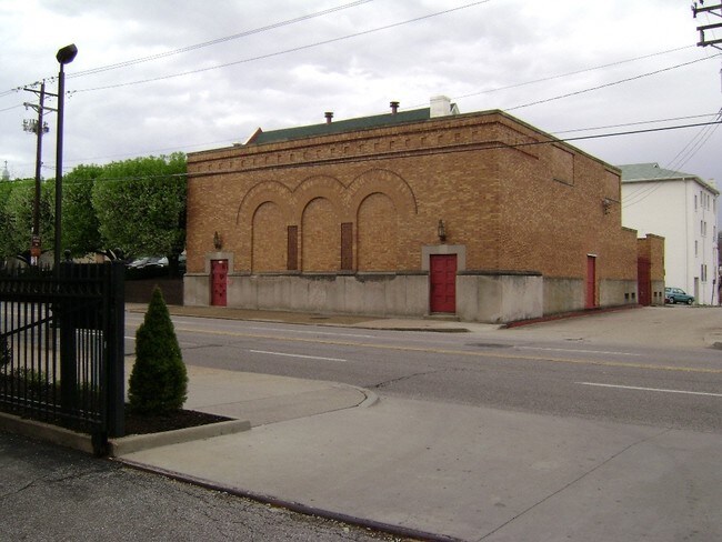

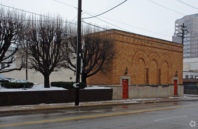
Property Detail
319 Madison Ave
Cincinnati, OH-KY-IN
ORIGINAL PLAT OF COV PT LOTS 276-277 55'X 95' WS MADISON AVE
054-12-06-002.00
KENTON
Officebuilding
Kentucky
B and X Area of moderate flood hazard, usually the area between the limits of the 100-year and 500-year floods.
276,27
2025
0.12 AC
2025
Covington/Newport
067000
Cincinnati/Dayton
3,528 SF
NEARBY LISTINGS FOR SALE OR LEASE
DEMOGRAPHICS near 319 Madison Ave
1 mile
3 mile
5 mile
2025 Total Population
18,579
139,285
291,336
2030 Population
19,557
144,023
299,779
Pop Growth 2025-2030
+ 5.26%
+ 3.40%
+ 2.90%
Average Age
39
38
37
2025 Total Households
10,034
64,691
127,057
HH Growth 2025-2030
+ 5.79%
+ 3.60%
+ 3.08%
Median Household Inc
$66,950
$63,088
$60,461
Avg Household Size
1.80
2.00
2.10
2025 Avg HH Vehicles
1.00
1.00
1.00
Median Home Value
$327,038
$251,865
$262,253
Median Year Built
1949
1949
1952
Nearby Places
Map Layers
Map Styles
 Street
 Aerial
Layers
 Traffic
 Biking
Places
Listings with unknown addresses are not visible on the map
- Restaurants
- Banks
- Shops
- Fitness
- Groceries
PUBLIC TRANSPORTATION
TRANSIT/SUBWAY
The Banks Station - 2Nd & Main (Streetcar - OTR - Banks - Southwest Ohio Regional Transit Authority)
Drive
Walk
Distance
The Banks Station - 2Nd & Main (Streetcar - OTR - Banks - Southwest Ohio Regional Transit Authority)
4 min
17 min
0.9 mi
Fountain Square Station - 5Th & Walnut (Streetcar - OTR - Banks - Southwest Ohio Regional Transit Authority)
Drive
Walk
Distance
Fountain Square Station - 5Th & Walnut (Streetcar - OTR - Banks - Southwest Ohio Regional Transit Authority)
5 min
20 min
1.1 mi
COMMUTER RAIL
Cincinnati Union Terminal (Cardinal - Amtrak)
Drive
Walk
Distance
Cincinnati Union Terminal (Cardinal - Amtrak)
7 min
3.1 mi
AIRPORT
Cincinnati/Northern Kentucky International
Drive
Walk
Distance
Cincinnati/Northern Kentucky International
26 min
13.2 mi
Freight Ports
Port of Toledo
Drive
Walk
Distance
Port of Toledo
244 min
207.7 mi
Nearby Properties
Address
Land Use
TOTAL SIZE
Lot Size
Zoning
Address
Land Use
TOTAL SIZE
Lot Size
Zoning
39.99 AC
MG
Address
Land Use
TOTAL SIZE
Lot Size
Zoning
11.82 AC
Address
Land Use
TOTAL SIZE
Lot Size
Zoning
11.62 AC
Address
Land Use
TOTAL SIZE
Lot Size
Zoning
19.36 AC
Address
Land Use
TOTAL SIZE
Lot Size
Zoning
17.10 AC
DD
Address
Land Use
TOTAL SIZE
Lot Size
Zoning
1.97 AC
DD
Address
Land Use
TOTAL SIZE
Lot Size
Zoning
11.41 AC
IR
Address
Land Use
TOTAL SIZE
Lot Size
Zoning
411,750 SF
21.25 AC
Address
Land Use
TOTAL SIZE
Lot Size
Zoning
60,750 SF
1.52 AC
Address
Land Use
TOTAL SIZE
Lot Size
Zoning
2.60 AC
Address
Land Use
TOTAL SIZE
Lot Size
Zoning
9.55 AC
Address
Land Use
TOTAL SIZE
Lot Size
Zoning
19.43 AC
Address
Land Use
TOTAL SIZE
Lot Size
Zoning
89,500 SF
0.58 AC
Address
Land Use
TOTAL SIZE
Lot Size
Zoning
290,233 SF
Address
Land Use
TOTAL SIZE
Lot Size
Zoning
3.51 AC
DD
Address
Land Use
TOTAL SIZE
Lot Size
Zoning
9,962 SF
712 AC
Address
Land Use
TOTAL SIZE
Lot Size
Zoning
Address
Land Use
TOTAL SIZE
Lot Size
Zoning
153,312 SF
4 AC
Address
Land Use
TOTAL SIZE
Lot Size
Zoning
9.14 AC
Address
Land Use
TOTAL SIZE
Lot Size
Zoning
21.55 AC
Address
Land Use
TOTAL SIZE
Lot Size
Zoning
298,611 SF
Address
Land Use
TOTAL SIZE
Lot Size
Zoning
20.02 AC
Address
Land Use
TOTAL SIZE
Lot Size
Zoning
12.13 AC
Address
Land Use
TOTAL SIZE
Lot Size
Zoning
2.46 AC
Address
Land Use
TOTAL SIZE
Lot Size
Zoning
165,016 SF
15.23 AC
Address
Land Use
TOTAL SIZE
Lot Size
Zoning
20.49 AC
Address
Land Use
TOTAL SIZE
Lot Size
Zoning
256,000 SF
Address
Land Use
TOTAL SIZE
Lot Size
Zoning
1.95 AC
Address
Land Use
TOTAL SIZE
Lot Size
Zoning
12,150 SF
10.02 AC
Address
Land Use
TOTAL SIZE
Lot Size
Zoning
19,816 SF
26.42 AC
The World's #1 Commercial Real Estate Marketplace
Connect with us
© 2026 CoStar Group
The information above has been obtained from sources believed reliable. While we do not doubt its accuracy we have not verified it and make no guarantee, warranty or representation about it. It is your responsibility to independently confirm its accuracy and completeness. Any projections, opinions, assumptions, or estimates used are for example only and do not represent the current or future performance of the property. The value of this transaction to you depends on tax and other factors which should be evaluated by your tax, financial, and legal advisors. You and your advisors should conduct a careful, independent investigation of the property to determine to your satisfaction the suitability of the property for your needs.