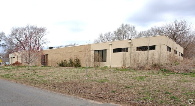
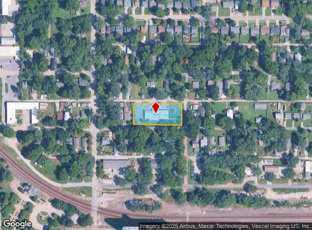
Property Record
319 Perry St, Lawrence, KS 66044

NEARBY LISTINGS FOR SALE OR LEASE
Property Detail
319 Perry St
Lawrence, KS
Subdivision 1255
023-079-30-0-10-17-008.00-0
NORTH LAWRENCE ADD NO 3 LTS 125,126,127,128,129 & 130 (N07210,11,12,13,14 & 15 COMBINED 1988)
Officebuilding
Douglas
X
Kansas
20045C0176E
125-130
0
0.83 AC
2025
Lawrence
000100
Kansas City
8,740 SF
DEMOGRAPHICS near 319 Perry St
1 Mile
3 Mile
5 Mile
2024 Total Population
5,843
52,735
95,302
2029 Population
5,977
53,816
97,268
Pop Growth 2024-2029
+ 2.29%
+ 2.05%
+ 2.06%
Average Age
38
34
35
2024 Total Households
2,690
21,207
39,835
HH Growth 2024-2029
+ 2.42%
+ 2.29%
+ 2.24%
Median Household Inc
$50,299
$50,889
$54,296
Avg Household Size
2.10
2.10
2.20
2024 Avg HH Vehicles
2.00
2.00
2.00
Median Home Value
$189,202
$197,839
$231,419
Median Year Built
1961
1973
1987
Nearby Places
Map Layers
Map Styles
 Street
 Aerial
- Restaurants
- Banks
- Shops
- Fitness
- Groceries
PUBLIC TRANSPORTATION
COMMUTER RAIL
DRIVE
WALK
Distance
4 min
1.2 mi
AIRPORT
Kansas City International
DRIVE
WALK
Distance
Kansas City International
57 min
49.2 mi
Nearby Properties
Address
Land Use
TOTAL SIZE
Lot Size
Zoning
Address
Land Use
TOTAL SIZE
Lot Size
Zoning
1,709,524 SF
32.03 AC
RD
Address
Land Use
TOTAL SIZE
Lot Size
Zoning
1,258,819 SF
106.65 AC
RD
Address
Land Use
TOTAL SIZE
Lot Size
Zoning
1,264,810 SF
129.10 AC
RD
Address
Land Use
TOTAL SIZE
Lot Size
Zoning
63,837 SF
20.79 AC
H
Address
Land Use
TOTAL SIZE
Lot Size
Zoning
632,738 SF
292.10 AC
RS2
Address
Land Use
TOTAL SIZE
Lot Size
Zoning
335,349 SF
3.17 AC
RD
Address
Land Use
TOTAL SIZE
Lot Size
Zoning
112,168 SF
38.08 AC
RD
Address
Land Use
TOTAL SIZE
Lot Size
Zoning
200,960 SF
9.20 AC
RD
Address
Land Use
TOTAL SIZE
Lot Size
Zoning
249,773 SF
34.84 AC
RS2
Address
Land Use
TOTAL SIZE
Lot Size
Zoning
336,701 SF
5.20 AC
RD
Address
Land Use
TOTAL SIZE
Lot Size
Zoning
112,500 SF
3.90 AC
RM1
Address
Land Use
TOTAL SIZE
Lot Size
Zoning
47,457 SF
2.58 AC
Address
Land Use
TOTAL SIZE
Lot Size
Zoning
220,557 SF
8.90 AC
RD
Address
Land Use
TOTAL SIZE
Lot Size
Zoning
162,086 SF
3 AC
RD
Address
Land Use
TOTAL SIZE
Lot Size
Zoning
67,500 SF
4.03 AC
RM1
Address
Land Use
TOTAL SIZE
Lot Size
Zoning
181,346 SF
21.40 AC
497
Address
Land Use
TOTAL SIZE
Lot Size
Zoning
186,889 SF
3.60 AC
RD
Address
Land Use
TOTAL SIZE
Lot Size
Zoning
92,295 SF
10.40 AC
RS1
Address
Land Use
TOTAL SIZE
Lot Size
Zoning
143,467 SF
2.80 AC
RM1
Address
Land Use
TOTAL SIZE
Lot Size
Zoning
104,785 SF
105.60 AC
RS1
Address
Land Use
TOTAL SIZE
Lot Size
Zoning
78,051 SF
37.20 AC
RS2
Address
Land Use
TOTAL SIZE
Lot Size
Zoning
5,984 SF
142.30 AC
M2
Address
Land Use
TOTAL SIZE
Lot Size
Zoning
92,819 SF
3.10 AC
RO2
Address
Land Use
TOTAL SIZE
Lot Size
Zoning
52,000 SF
36 AC
RS1
Address
Land Use
TOTAL SIZE
Lot Size
Zoning
19,985 SF
103.37 AC
RS1
Address
Land Use
TOTAL SIZE
Lot Size
Zoning
337,280 SF
0.60 AC
RD
Address
Land Use
TOTAL SIZE
Lot Size
Zoning
31,750 SF
0.73 AC
Address
Land Use
TOTAL SIZE
Lot Size
Zoning
34,479 SF
1.08 AC
C4
Address
Land Use
TOTAL SIZE
Lot Size
Zoning
131,625 SF
2.32 AC
C3
Address
Land Use
TOTAL SIZE
Lot Size
Zoning
2,728 SF
305 AC
RS1
The World's #1 Commercial Real Estate Marketplace
Connect with us
© 2025 CoStar Group
The information above has been obtained from sources believed reliable. While we do not doubt its accuracy we have not verified it and make no guarantee, warranty or representation about it. It is your responsibility to independently confirm its accuracy and completeness. Any projections, opinions, assumptions, or estimates used are for example only and do not represent the current or future performance of the property. The value of this transaction to you depends on tax and other factors which should be evaluated by your tax, financial, and legal advisors. You and your advisors should conduct a careful, independent investigation of the property to determine to your satisfaction the suitability of the property for your needs.