Property Record
319 S Center St, Hickory, NC 28602


NEARBY LISTINGS FOR SALE OR LEASE
-
-
View all Hickory listings for sale on LoopNet.com
Property Detail
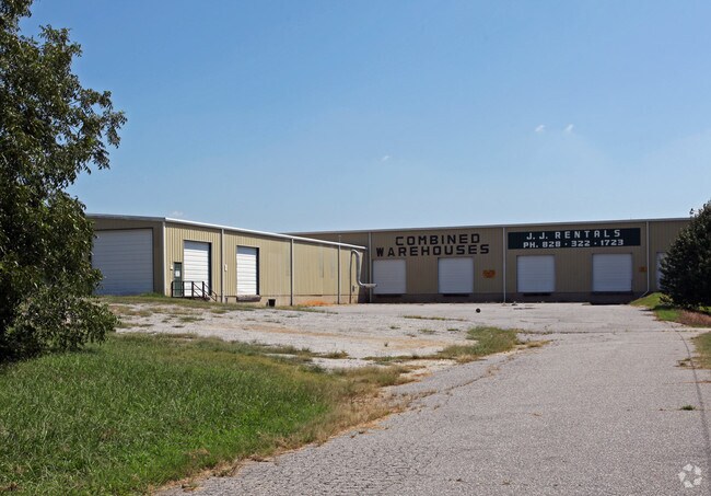
319 S Center St
56531
Robert L Johnson Jr & Pearl Saunder
Warehouse
319 S CENTER ST HICKORY, NC 28602
X
Burke
3710278200J
North Carolina
2025
3.85 AC
2025
Burke County
011101
Charlotte
80,480 SF
Hickory-Lenoir-Morganton, NC
DEMOGRAPHICS near 319 S Center St
1 Mile
3 Mile
5 Mile
2024 Total Population
1,214
12,476
37,759
2029 Population
1,207
12,667
38,789
Pop Growth 2024-2029
(0.58%)
+ 1.53%
+ 2.73%
Average Age
44
43
42
2024 Total Households
516
5,028
15,169
HH Growth 2024-2029
(0.39%)
+ 1.53%
+ 2.74%
Median Household Inc
$45,500
$49,159
$53,469
Avg Household Size
2.30
2.40
2.40
2024 Avg HH Vehicles
2.00
2.00
2.00
Median Home Value
$158,741
$140,789
$158,699
Median Year Built
1974
1975
1977
Nearby Places
Map Layers
Map Styles
 Street
 Aerial
- Restaurants
- Banks
- Shops
- Fitness
- Groceries
Nearby Properties
Address
Land Use
TOTAL SIZE
Lot Size
Zoning
Address
Land Use
TOTAL SIZE
Lot Size
Zoning
52,542 SF
RESIDENTIA
Address
Land Use
TOTAL SIZE
Lot Size
Zoning
301,264 SF
19.88 AC
I
Address
Land Use
TOTAL SIZE
Lot Size
Zoning
173,730 SF
16.80 AC
IND
Address
Land Use
TOTAL SIZE
Lot Size
Zoning
36,767 SF
7.49 AC
RESIDENTIA
Address
Land Use
TOTAL SIZE
Lot Size
Zoning
85,988 SF
9.67 AC
ED
Address
Land Use
TOTAL SIZE
Lot Size
Zoning
240,210 SF
11.64 AC
I
Address
Land Use
TOTAL SIZE
Lot Size
Zoning
29.21 AC
R-2
Address
Land Use
TOTAL SIZE
Lot Size
Zoning
51,668 SF
CENTRAL BU
Address
Land Use
TOTAL SIZE
Lot Size
Zoning
151,117 SF
26.59 AC
GENERAL MA
Address
Land Use
TOTAL SIZE
Lot Size
Zoning
19,107 SF
R-3 DIST -
Address
Land Use
TOTAL SIZE
Lot Size
Zoning
335,352 SF
55.48 AC
INDUSTRIAL
Address
Land Use
TOTAL SIZE
Lot Size
Zoning
44,046 SF
4.61 AC
R-4
Address
Land Use
TOTAL SIZE
Lot Size
Zoning
6,310 SF
CENTRAL BU
Address
Land Use
TOTAL SIZE
Lot Size
Zoning
64,928 SF
24.49 AC
ED
Address
Land Use
TOTAL SIZE
Lot Size
Zoning
12,472 SF
RESIDENTIA
Address
Land Use
TOTAL SIZE
Lot Size
Zoning
91,379 SF
11.89 AC
GENERAL MA
Address
Land Use
TOTAL SIZE
Lot Size
Zoning
92,500 SF
22.91 AC
GENERAL MA
Address
Land Use
TOTAL SIZE
Lot Size
Zoning
38,464 SF
10.37 AC
GENERAL MA
Address
Land Use
TOTAL SIZE
Lot Size
Zoning
42,950 SF
6.55 AC
CENTRAL BU
Address
Land Use
TOTAL SIZE
Lot Size
Zoning
131,144 SF
10.76 AC
I
Address
Land Use
TOTAL SIZE
Lot Size
Zoning
16.24 AC
INDUSTRIAL
Address
Land Use
TOTAL SIZE
Lot Size
Zoning
41,764 SF
8.63 AC
C-4
Address
Land Use
TOTAL SIZE
Lot Size
Zoning
10,336 SF
1.43 AC
HIGHWAY BU
Address
Land Use
TOTAL SIZE
Lot Size
Zoning
64,019 SF
22.06 AC
GENERAL MA
Address
Land Use
TOTAL SIZE
Lot Size
Zoning
57,968 SF
4.74 AC
ED
Address
Land Use
TOTAL SIZE
Lot Size
Zoning
37,812 SF
7.70 AC
RESIDENTIA
Address
Land Use
TOTAL SIZE
Lot Size
Zoning
44,074 SF
5.65 AC
C-3
Address
Land Use
TOTAL SIZE
Lot Size
Zoning
105,976 SF
12.26 AC
IND
Address
Land Use
TOTAL SIZE
Lot Size
Zoning
3.05 AC
R-40
Address
Land Use
TOTAL SIZE
Lot Size
Zoning
3,624 SF
1.33 AC
HIGHWAY BU
The World's #1 Commercial Real Estate Marketplace
Connect with us
© 2025 CoStar Group
The information above has been obtained from sources believed reliable. While we do not doubt its accuracy we have not verified it and make no guarantee, warranty or representation about it. It is your responsibility to independently confirm its accuracy and completeness. Any projections, opinions, assumptions, or estimates used are for example only and do not represent the current or future performance of the property. The value of this transaction to you depends on tax and other factors which should be evaluated by your tax, financial, and legal advisors. You and your advisors should conduct a careful, independent investigation of the property to determine to your satisfaction the suitability of the property for your needs.