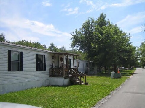
Property Record
319 State Route 52 E, Liberty, NY 12754


NEARBY LISTINGS FOR SALE OR LEASE
Property Detail
319 State Route 52 E
3689-030-0-0001-087-001
68T/5DW/2SLAB/APTS/POOL
Mobilehomepark
Sullivan
X
New York
36105C0315F
87.001
2025
35.47 AC
2024
Other Market Areas
950500
Monticello, NY
4,629 SF
DEMOGRAPHICS near 319 State Route 52 E
1 Mile
3 Mile
5 Mile
2024 Total Population
394
7,186
13,703
2029 Population
402
7,361
14,135
Pop Growth 2024-2029
+ 2.03%
+ 2.44%
+ 3.15%
Average Age
44
40
40
2024 Total Households
167
2,640
5,071
HH Growth 2024-2029
+ 2.40%
+ 2.73%
+ 3.53%
Median Household Inc
$31,250
$42,623
$44,327
Avg Household Size
2.10
2.50
2.50
2024 Avg HH Vehicles
1.00
1.00
2.00
Median Home Value
$261,538
$170,188
$175,488
Median Year Built
1968
1967
1970
Nearby Places
Map Layers
Map Styles
 Street
 Aerial
- Restaurants
- Banks
- Shops
- Fitness
- Groceries
PUBLIC TRANSPORTATION
AIRPORT
New York Stewart International
DRIVE
WALK
Distance
New York Stewart International
68 min
47.7 mi
Nearby Properties
Address
Land Use
TOTAL SIZE
Lot Size
Zoning
Address
Land Use
TOTAL SIZE
Lot Size
Zoning
168,343 SF
398 AC
R1
Address
Land Use
TOTAL SIZE
Lot Size
Zoning
17,622 SF
20 AC
Address
Land Use
TOTAL SIZE
Lot Size
Zoning
58,488 SF
50 AC
C
Address
Land Use
TOTAL SIZE
Lot Size
Zoning
16,872 SF
67 AC
C
Address
Land Use
TOTAL SIZE
Lot Size
Zoning
127,937 SF
12.41 AC
C
Address
Land Use
TOTAL SIZE
Lot Size
Zoning
108,721 SF
3.93 AC
M
Address
Land Use
TOTAL SIZE
Lot Size
Zoning
58,675 SF
6.46 AC
C
Address
Land Use
TOTAL SIZE
Lot Size
Zoning
1,042,540 SF
14.62 AC
C
Address
Land Use
TOTAL SIZE
Lot Size
Zoning
5,676 SF
4.56 AC
B3
Address
Land Use
TOTAL SIZE
Lot Size
Zoning
8,080 SF
7.07 AC
C
Address
Land Use
TOTAL SIZE
Lot Size
Zoning
34,884 SF
9.36 AC
SC
Address
Land Use
TOTAL SIZE
Lot Size
Zoning
3,196 SF
80.90 AC
RD2
Address
Land Use
TOTAL SIZE
Lot Size
Zoning
14,658 SF
5.67 AC
M
Address
Land Use
TOTAL SIZE
Lot Size
Zoning
4,230 SF
59.74 AC
C
Address
Land Use
TOTAL SIZE
Lot Size
Zoning
5,996 SF
35.47 AC
C
Address
Land Use
TOTAL SIZE
Lot Size
Zoning
65,628 SF
2.70 AC
C
Address
Land Use
TOTAL SIZE
Lot Size
Zoning
23,768 SF
2.24 AC
C
Address
Land Use
TOTAL SIZE
Lot Size
Zoning
6,048 SF
105.58 AC
RD2
Address
Land Use
TOTAL SIZE
Lot Size
Zoning
9,922 SF
62.53 AC
IC
Address
Land Use
TOTAL SIZE
Lot Size
Zoning
9,543 SF
67.02 AC
IC
Address
Land Use
TOTAL SIZE
Lot Size
Zoning
41,406 SF
10.60 AC
A1
Address
Land Use
TOTAL SIZE
Lot Size
Zoning
11,068 SF
7.51 AC
Address
Land Use
TOTAL SIZE
Lot Size
Zoning
18,472 SF
1.33 AC
C
Address
Land Use
TOTAL SIZE
Lot Size
Zoning
42,371 SF
1.20 AC
C
Address
Land Use
TOTAL SIZE
Lot Size
Zoning
15,068 SF
8.41 AC
C
Address
Land Use
TOTAL SIZE
Lot Size
Zoning
22,338 SF
3 AC
C
Address
Land Use
TOTAL SIZE
Lot Size
Zoning
11,627 SF
1.95 AC
M
Address
Land Use
TOTAL SIZE
Lot Size
Zoning
38,080 SF
5.94 AC
C
Address
Land Use
TOTAL SIZE
Lot Size
Zoning
4,092 SF
40.17 AC
Address
Land Use
TOTAL SIZE
Lot Size
Zoning
19,434 SF
3 AC
C
The World's #1 Commercial Real Estate Marketplace
Connect with us
© 2026 CoStar Group
The information above has been obtained from sources believed reliable. While we do not doubt its accuracy we have not verified it and make no guarantee, warranty or representation about it. It is your responsibility to independently confirm its accuracy and completeness. Any projections, opinions, assumptions, or estimates used are for example only and do not represent the current or future performance of the property. The value of this transaction to you depends on tax and other factors which should be evaluated by your tax, financial, and legal advisors. You and your advisors should conduct a careful, independent investigation of the property to determine to your satisfaction the suitability of the property for your needs.