Property Record
319 W Williamsburg Rd, Sandston, VA 23150
NEARBY LISTINGS FOR SALE OR LEASE
Property Detail
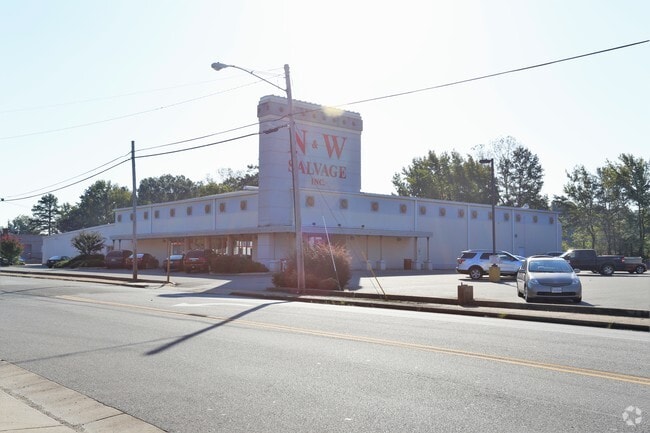
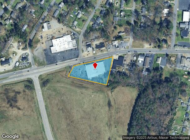
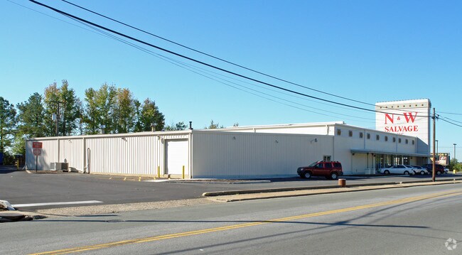
319 W Williamsburg Rd
825-716-1809
Sandston
Storebuilding
0164150001 0000D; SANDSTON SC B AC 1.88 PT LT D 11 B2 8
X
Henrico
51087C0164D
Virginia
2025
1.88 AC
2025
East End
201701
Richmond VA
22,278 SF
Richmond, VA
DEMOGRAPHICS near 319 W Williamsburg Rd
1 Mile
3 Mile
5 Mile
2024 Total Population
4,411
30,610
78,605
2029 Population
4,388
30,432
79,277
Pop Growth 2024-2029
(0.52%)
(0.58%)
+ 0.85%
Average Age
39
40
40
2024 Total Households
1,748
12,412
31,849
HH Growth 2024-2029
(0.57%)
(0.59%)
+ 0.85%
Median Household Inc
$59,594
$54,771
$56,206
Avg Household Size
2.50
2.40
2.40
2024 Avg HH Vehicles
2.00
2.00
2.00
Median Home Value
$157,112
$165,928
$201,378
Median Year Built
1972
1977
1979
Nearby Places
Map Layers
Map Styles
 Street
 Aerial
- Restaurants
- Banks
- Shops
- Fitness
- Groceries
PUBLIC TRANSPORTATION
COMMUTER RAIL
DRIVE
WALK
Distance
13 min
8.4 mi
AIRPORT
Richmond International
DRIVE
WALK
Distance
Richmond International
5 min
1.5 mi
Freight Ports
Virginia Port Authority - Richmond
DRIVE
WALK
Distance
Virginia Port Authority - Richmond
22 min
12.4 mi
Nearby Properties
Address
Land Use
TOTAL SIZE
Lot Size
Zoning
Address
Land Use
TOTAL SIZE
Lot Size
Zoning
548,680 SF
2,298.89 AC
MIXE
Address
Land Use
TOTAL SIZE
Lot Size
Zoning
143,287 SF
56.39 AC
MIXE
Address
Land Use
TOTAL SIZE
Lot Size
Zoning
60,032 SF
62 AC
B-3C
Address
Land Use
TOTAL SIZE
Lot Size
Zoning
920,673 SF
99.01 AC
MIXE
Address
Land Use
TOTAL SIZE
Lot Size
Zoning
49,152 SF
31.21 AC
M-1
Address
Land Use
TOTAL SIZE
Lot Size
Zoning
522,399 SF
58.07 AC
M-1
Address
Land Use
TOTAL SIZE
Lot Size
Zoning
186,390 SF
13.50 AC
R-5
Address
Land Use
TOTAL SIZE
Lot Size
Zoning
444,069 SF
23.82 AC
M-1
Address
Land Use
TOTAL SIZE
Lot Size
Zoning
173,637 SF
15.48 AC
R-5
Address
Land Use
TOTAL SIZE
Lot Size
Zoning
322,000 SF
15.94 AC
M-1
Address
Land Use
TOTAL SIZE
Lot Size
Zoning
278,967 SF
26.07 AC
M1-C
Address
Land Use
TOTAL SIZE
Lot Size
Zoning
181,200 SF
14.74 AC
R-5
Address
Land Use
TOTAL SIZE
Lot Size
Zoning
146,560 SF
11.09 AC
R-5
Address
Land Use
TOTAL SIZE
Lot Size
Zoning
15,680 SF
39.75 AC
R-3
Address
Land Use
TOTAL SIZE
Lot Size
Zoning
8,440 SF
8.27 AC
R-6
Address
Land Use
TOTAL SIZE
Lot Size
Zoning
179,359 SF
11.85 AC
M-1
Address
Land Use
TOTAL SIZE
Lot Size
Zoning
190,138 SF
16.99 AC
MIXE
Address
Land Use
TOTAL SIZE
Lot Size
Zoning
246,760 SF
59.70 AC
M-2C
Address
Land Use
TOTAL SIZE
Lot Size
Zoning
108,738 SF
6.39 AC
R-6
Address
Land Use
TOTAL SIZE
Lot Size
Zoning
241,800 SF
M-2C
Address
Land Use
TOTAL SIZE
Lot Size
Zoning
142,379 SF
17.69 AC
M-1
Address
Land Use
TOTAL SIZE
Lot Size
Zoning
76,208 SF
24.97 AC
B-3
Address
Land Use
TOTAL SIZE
Lot Size
Zoning
95,288 SF
9.94 AC
MIXE
Address
Land Use
TOTAL SIZE
Lot Size
Zoning
137,051 SF
16.39 AC
B-3C
Address
Land Use
TOTAL SIZE
Lot Size
Zoning
69,248 SF
5.24 AC
B-3C
Address
Land Use
TOTAL SIZE
Lot Size
Zoning
53,530 SF
4.50 AC
M-1C
Address
Land Use
TOTAL SIZE
Lot Size
Zoning
144,135 SF
9.72 AC
M-1
Address
Land Use
TOTAL SIZE
Lot Size
Zoning
127,868 SF
12.85 AC
B-3C
Address
Land Use
TOTAL SIZE
Lot Size
Zoning
9.66 AC
R-5
Address
Land Use
TOTAL SIZE
Lot Size
Zoning
156,390 SF
13.37 AC
B-3C
The World's #1 Commercial Real Estate Marketplace
Connect with us
© 2025 CoStar Group
The information above has been obtained from sources believed reliable. While we do not doubt its accuracy we have not verified it and make no guarantee, warranty or representation about it. It is your responsibility to independently confirm its accuracy and completeness. Any projections, opinions, assumptions, or estimates used are for example only and do not represent the current or future performance of the property. The value of this transaction to you depends on tax and other factors which should be evaluated by your tax, financial, and legal advisors. You and your advisors should conduct a careful, independent investigation of the property to determine to your satisfaction the suitability of the property for your needs.