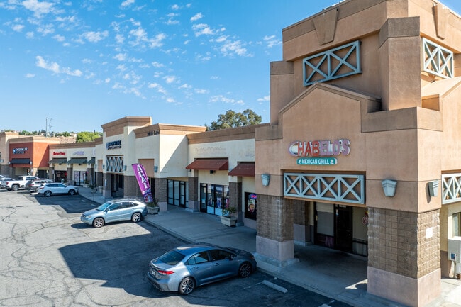
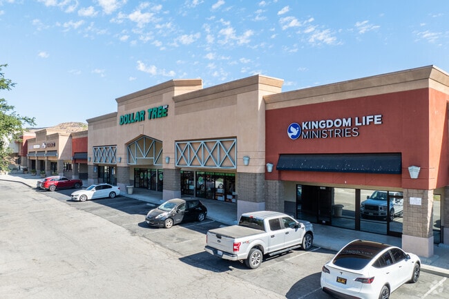
Property Record
31910 Castaic Rd, Castaic, CA 91384


This Property Is For Sale
Property Detail
31910 Castaic Rd
2865-036-046
PM 361-33-37 THAT POR IN TRA 13147 LOT 1
Storemultistory
LOS ANGELES
LCC3
California
A Areas with a 1% annual chance of flooding and a 26% chance of flooding over the life of a 30-year mortgage.
1
2025
3.94 AC
2025
Santa Clarita Valley
920102
Los Angeles
146,762 SF
Los Angeles-Long Beach-Glendale, CA
NEARBY LISTINGS FOR SALE OR LEASE
DEMOGRAPHICS near 31910 Castaic Rd
1 mile
3 mile
5 mile
2025 Total Population
6,511
21,191
40,697
2030 Population
6,314
20,951
40,168
Pop Growth 2025-2030
(3.03%)
(1.13%)
(1.30%)
Average Age
41
40
39
2025 Total Households
2,198
4,932
10,750
HH Growth 2025-2030
(3.41%)
(2.01%)
(1.89%)
Median Household Inc
$105,840
$139,541
$151,589
Avg Household Size
2.90
3.10
3.20
2025 Avg HH Vehicles
2.00
3.00
2.00
Median Home Value
$736,086
$764,719
$782,238
Median Year Built
1985
1992
2000
Nearby Places
Map Layers
Map Styles
 Street
 Aerial
Layers
 Traffic
 Biking
Places
Listings with unknown addresses are not visible on the map
- Restaurants
- Banks
- Shops
- Fitness
- Groceries
PUBLIC TRANSPORTATION
AIRPORT
Bob Hope
Drive
Walk
Distance
Bob Hope
35 min
27.9 mi
Freight Ports
The Port of Hueneme
Drive
Walk
Distance
The Port of Hueneme
73 min
52.2 mi
Nearby Properties
Address
Land Use
TOTAL SIZE
Lot Size
Zoning
Address
Land Use
TOTAL SIZE
Lot Size
Zoning
125,154 SF
6.42 AC
LAC2
Address
Land Use
TOTAL SIZE
Lot Size
Zoning
3,588 SF
1.93 AC
LCC3*
Address
Land Use
TOTAL SIZE
Lot Size
Zoning
37,110 SF
2.37 AC
LCM1*
Address
Land Use
TOTAL SIZE
Lot Size
Zoning
74,372 SF
3.28 AC
Address
Land Use
TOTAL SIZE
Lot Size
Zoning
13,566 SF
1.20 AC
LCRPD80005
Address
Land Use
TOTAL SIZE
Lot Size
Zoning
77,608 SF
44.95 AC
LCM2DP*
Address
Land Use
TOTAL SIZE
Lot Size
Zoning
51,619 SF
5.15 AC
LCA2
Address
Land Use
TOTAL SIZE
Lot Size
Zoning
16,640 SF
0.97 AC
LCR3*
Address
Land Use
TOTAL SIZE
Lot Size
Zoning
22,227 SF
2.53 AC
LCA12OOOO*
Address
Land Use
TOTAL SIZE
Lot Size
Zoning
8,529 SF
2.09 AC
LCM1*
Address
Land Use
TOTAL SIZE
Lot Size
Zoning
16,425 SF
0.82 AC
LCC3*
Address
Land Use
TOTAL SIZE
Lot Size
Zoning
90,128 SF
3.85 AC
LAM1*
Address
Land Use
TOTAL SIZE
Lot Size
Zoning
36,352 SF
1.50 AC
LCR3*
Address
Land Use
TOTAL SIZE
Lot Size
Zoning
10,720 SF
0.37 AC
LCM1*
Address
Land Use
TOTAL SIZE
Lot Size
Zoning
9,936 SF
7.03 AC
LCM1
Address
Land Use
TOTAL SIZE
Lot Size
Zoning
1,176 SF
5.12 AC
LCM1*
Address
Land Use
TOTAL SIZE
Lot Size
Zoning
23,070 SF
1.73 AC
LCM1*
Address
Land Use
TOTAL SIZE
Lot Size
Zoning
15,949 SF
0.68 AC
LCC3*
Address
Land Use
TOTAL SIZE
Lot Size
Zoning
2,570 SF
0.69 AC
LCM1-A1700
Address
Land Use
TOTAL SIZE
Lot Size
Zoning
8.11 AC
LCA22*
Address
Land Use
TOTAL SIZE
Lot Size
Zoning
6,782 SF
2.89 AC
LCM1*
Address
Land Use
TOTAL SIZE
Lot Size
Zoning
1,575 SF
0.61 AC
LCM1*
Address
Land Use
TOTAL SIZE
Lot Size
Zoning
12,742 SF
1.39 AC
LCM1*
Address
Land Use
TOTAL SIZE
Lot Size
Zoning
53,180 SF
2.44 AC
LCM1*
Address
Land Use
TOTAL SIZE
Lot Size
Zoning
6,171 SF
3.32 AC
LCM1*
Address
Land Use
TOTAL SIZE
Lot Size
Zoning
14,126 SF
LCM1*
The World's #1 Commercial Real Estate Marketplace
Connect with us
© 2026 CoStar Group
The information above has been obtained from sources believed reliable. While we do not doubt its accuracy we have not verified it and make no guarantee, warranty or representation about it. It is your responsibility to independently confirm its accuracy and completeness. Any projections, opinions, assumptions, or estimates used are for example only and do not represent the current or future performance of the property. The value of this transaction to you depends on tax and other factors which should be evaluated by your tax, financial, and legal advisors. You and your advisors should conduct a careful, independent investigation of the property to determine to your satisfaction the suitability of the property for your needs.