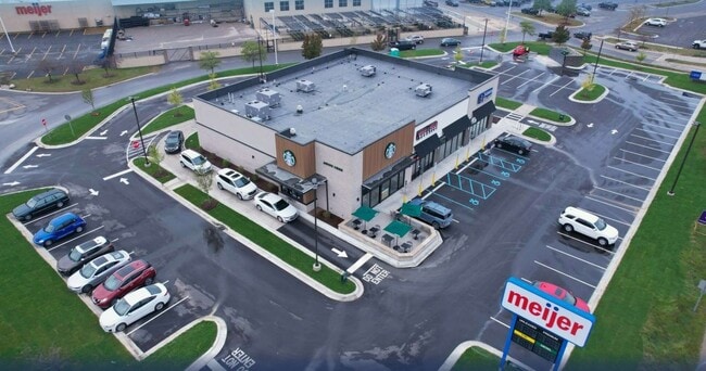
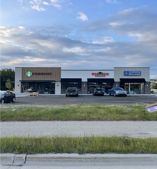
Property Record
3195 Gratiot Blvd, Marysville, MI 48040
NEARBY LISTINGS FOR SALE OR LEASE
Property Detail
3195 Gratiot Blvd
Detroit-Warren-Dearborn, MI
Commencing At The Northwest Corner Of
74-03-765-0001-100
St. Clair
Commercialnec
Michigan
0
1.53 AC
2025
St Clair & Lapeer Counties
637200
Detroit
DEMOGRAPHICS near 3195 Gratiot Blvd
1 Mile
3 Mile
5 Mile
2024 Total Population
4,463
15,943
33,764
2029 Population
4,436
15,872
33,656
Pop Growth 2024-2029
(0.60%)
(0.45%)
(0.32%)
Average Age
41
41
41
2024 Total Households
1,807
6,487
13,469
HH Growth 2024-2029
(0.77%)
(0.54%)
(0.45%)
Median Household Inc
$72,666
$57,903
$55,000
Avg Household Size
2.40
2.40
2.40
2024 Avg HH Vehicles
2.00
2.00
2.00
Median Home Value
$159,049
$160,170
$158,093
Median Year Built
1970
1979
1977
Nearby Places
Map Layers
Map Styles
 Street
 Aerial
- Restaurants
- Banks
- Shops
- Fitness
- Groceries
PUBLIC TRANSPORTATION
COMMUTER RAIL
DRIVE
WALK
Distance
10 min
5.0 mi
SALE & LEASE HISTORY
LISTING DATE
SALE/LEASE

Oct 04, 2024
For Sale
May 31, 2024
For Sale
Nearby Properties
Address
Land Use
TOTAL SIZE
Lot Size
Zoning
Address
Land Use
TOTAL SIZE
Lot Size
Zoning
682,515 SF
211.45 AC
M-2
Address
Land Use
TOTAL SIZE
Lot Size
Zoning
79,276 SF
316.65 AC
M-1
Address
Land Use
TOTAL SIZE
Lot Size
Zoning
1,246,586 SF
83.70 AC
M-2
Address
Land Use
TOTAL SIZE
Lot Size
Zoning
98,904 SF
29.48 AC
R1-A
Address
Land Use
TOTAL SIZE
Lot Size
Zoning
79,276 SF
311.74 AC
M-1
Address
Land Use
TOTAL SIZE
Lot Size
Zoning
204,347 SF
35.13 AC
C-2
Address
Land Use
TOTAL SIZE
Lot Size
Zoning
134,379 SF
15 AC
RM-2
Address
Land Use
TOTAL SIZE
Lot Size
Zoning
80,662 SF
R1-A
Address
Land Use
TOTAL SIZE
Lot Size
Zoning
138,360 SF
6.01 AC
M-1
Address
Land Use
TOTAL SIZE
Lot Size
Zoning
Address
Land Use
TOTAL SIZE
Lot Size
Zoning
77,868 SF
8.91 AC
RM-2
Address
Land Use
TOTAL SIZE
Lot Size
Zoning
108,767 SF
7.29 AC
R1-A
Address
Land Use
TOTAL SIZE
Lot Size
Zoning
83,623 SF
5.49 AC
M-1
Address
Land Use
TOTAL SIZE
Lot Size
Zoning
250,775 SF
11.29 AC
M-1
Address
Land Use
TOTAL SIZE
Lot Size
Zoning
69,440 SF
12.30 AC
C-2
Address
Land Use
TOTAL SIZE
Lot Size
Zoning
100,096 SF
13.85 AC
M-2
Address
Land Use
TOTAL SIZE
Lot Size
Zoning
50,314 SF
58.60 AC
M-2
Address
Land Use
TOTAL SIZE
Lot Size
Zoning
47,332 SF
19.33 AC
M-1
Address
Land Use
TOTAL SIZE
Lot Size
Zoning
213,967 SF
9.27 AC
M-1
Address
Land Use
TOTAL SIZE
Lot Size
Zoning
125,367 SF
19.45 AC
M1
Address
Land Use
TOTAL SIZE
Lot Size
Zoning
68,348 SF
6.33 AC
M-1
Address
Land Use
TOTAL SIZE
Lot Size
Zoning
4,480 SF
40 AC
MH
Address
Land Use
TOTAL SIZE
Lot Size
Zoning
37,998 SF
6.04 AC
C-2
Address
Land Use
TOTAL SIZE
Lot Size
Zoning
28,565 SF
R1-A
Address
Land Use
TOTAL SIZE
Lot Size
Zoning
58,656 SF
12.03 AC
I-H
Address
Land Use
TOTAL SIZE
Lot Size
Zoning
5,213 SF
45 AC
I-2
Address
Land Use
TOTAL SIZE
Lot Size
Zoning
55,760 SF
7.86 AC
M-1
Address
Land Use
TOTAL SIZE
Lot Size
Zoning
18,000 SF
9.62 AC
M-1
Address
Land Use
TOTAL SIZE
Lot Size
Zoning
16,621 SF
3.63 AC
C-3
Address
Land Use
TOTAL SIZE
Lot Size
Zoning
39,926 SF
8.94 AC
I-L
The World's #1 Commercial Real Estate Marketplace
Connect with us
© 2026 CoStar Group
The information above has been obtained from sources believed reliable. While we do not doubt its accuracy we have not verified it and make no guarantee, warranty or representation about it. It is your responsibility to independently confirm its accuracy and completeness. Any projections, opinions, assumptions, or estimates used are for example only and do not represent the current or future performance of the property. The value of this transaction to you depends on tax and other factors which should be evaluated by your tax, financial, and legal advisors. You and your advisors should conduct a careful, independent investigation of the property to determine to your satisfaction the suitability of the property for your needs.