Property Record
3199 Danieldale Rd, Lancaster, TX 75134
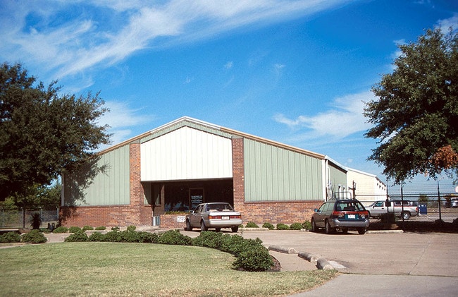

Property Detail
3199 Danieldale Rd
65119918010350000
SILAS B RUNYON ABST 1199 PG 180 S-3 6801800103500 26511991801
Officebuilding
DALLAS
Z47
Texas
B and X Area of moderate flood hazard, usually the area between the limits of the 100-year and 500-year floods.
4.85 AC
2024
SE Dallas/I-45
2025
Dallas/Ft Worth
016709
Dallas-Fort Worth-Arlington, TX
26,199 SF
NEARBY LISTINGS FOR SALE OR LEASE
DEMOGRAPHICS near 3199 Danieldale Rd
1 mile
3 mile
5 mile
2025 Total Population
2,729
69,559
209,367
2030 Population
2,792
71,367
215,580
Pop Growth 2025-2030
+ 2.31%
+ 2.60%
+ 2.97%
Average Age
34
38
38
2025 Total Households
850
23,697
72,900
HH Growth 2025-2030
+ 2.12%
+ 2.52%
+ 2.89%
Median Household Inc
$61,242
$61,372
$58,424
Avg Household Size
3.20
2.90
2.80
2025 Avg HH Vehicles
2.00
2.00
2.00
Median Home Value
$232,642
$250,467
$249,560
Median Year Built
1990
1985
1983
Nearby Places
Map Layers
Map Styles
 Street
 Aerial
Transit
 Traffic
 Biking
Places
Listings with unknown addresses are not visible on the map
- Restaurants
- Banks
- Shops
- Fitness
- Groceries
Nearby Properties
Address
Land Use
TOTAL SIZE
Lot Size
Zoning
Address
Land Use
TOTAL SIZE
Lot Size
Zoning
1,283,264 SF
78.52 AC
Z04
Address
Land Use
TOTAL SIZE
Lot Size
Zoning
1,316,325 SF
54.36 AC
Z111
Address
Land Use
TOTAL SIZE
Lot Size
Zoning
1,200,000 SF
60.01 AC
Z125
Address
Land Use
TOTAL SIZE
Lot Size
Zoning
1,126,320 SF
63.41 AC
Z111
Address
Land Use
TOTAL SIZE
Lot Size
Zoning
1,167,500 SF
46.04 AC
Z06
Address
Land Use
TOTAL SIZE
Lot Size
Zoning
1,015,340 SF
55.63 AC
Z239
Address
Land Use
TOTAL SIZE
Lot Size
Zoning
951,480 SF
50.63 AC
Z109
Address
Land Use
TOTAL SIZE
Lot Size
Zoning
948,392 SF
50.80 AC
Z109
Address
Land Use
TOTAL SIZE
Lot Size
Zoning
917,700 SF
44.27 AC
Z125
Address
Land Use
TOTAL SIZE
Lot Size
Zoning
900,000 SF
50.76 AC
Z04
Address
Land Use
TOTAL SIZE
Lot Size
Zoning
1,108,100 SF
65.25 AC
Z125
Address
Land Use
TOTAL SIZE
Lot Size
Zoning
872,640 SF
46.97 AC
Z125
Address
Land Use
TOTAL SIZE
Lot Size
Zoning
823,000 SF
45.10 AC
Z298
Address
Land Use
TOTAL SIZE
Lot Size
Zoning
713,000 SF
52.25 AC
Z125
Address
Land Use
TOTAL SIZE
Lot Size
Zoning
554,600 SF
50.31 AC
Z298
Address
Land Use
TOTAL SIZE
Lot Size
Zoning
550,800 SF
26.52 AC
Z239
Address
Land Use
TOTAL SIZE
Lot Size
Zoning
662,230 SF
38.49 AC
Z248
Address
Land Use
TOTAL SIZE
Lot Size
Zoning
660,400 SF
35.93 AC
Z125
Address
Land Use
TOTAL SIZE
Lot Size
Zoning
659,523 SF
35.33 AC
Z04
Address
Land Use
TOTAL SIZE
Lot Size
Zoning
595,148 SF
34.96 AC
Z39
Address
Land Use
TOTAL SIZE
Lot Size
Zoning
627,000 SF
37.09 AC
Z125
Address
Land Use
TOTAL SIZE
Lot Size
Zoning
123,880 SF
16.80 AC
Z236
Address
Land Use
TOTAL SIZE
Lot Size
Zoning
610,806 SF
33.66 AC
Z125
Address
Land Use
TOTAL SIZE
Lot Size
Zoning
610,806 SF
34.20 AC
Z125
Address
Land Use
TOTAL SIZE
Lot Size
Zoning
590,200 SF
31.83 AC
Z04
Address
Land Use
TOTAL SIZE
Lot Size
Zoning
507,318 SF
28.40 AC
Z111
Address
Land Use
TOTAL SIZE
Lot Size
Zoning
552,200 SF
41.36 AC
Z109
Address
Land Use
TOTAL SIZE
Lot Size
Zoning
610,669 SF
41.65 AC
Z125
Address
Land Use
TOTAL SIZE
Lot Size
Zoning
489,310 SF
33.91 AC
Z111
Address
Land Use
TOTAL SIZE
Lot Size
Zoning
531,254 SF
33.40 AC
Z06
The World's #1 Commercial Real Estate Marketplace
Connect with us
© 2026 CoStar Group
The information above has been obtained from sources believed reliable. While we do not doubt its accuracy we have not verified it and make no guarantee, warranty or representation about it. It is your responsibility to independently confirm its accuracy and completeness. Any projections, opinions, assumptions, or estimates used are for example only and do not represent the current or future performance of the property. The value of this transaction to you depends on tax and other factors which should be evaluated by your tax, financial, and legal advisors. You and your advisors should conduct a careful, independent investigation of the property to determine to your satisfaction the suitability of the property for your needs.