Property Record
3199 Northfork Rd, Elliston, VA 24087
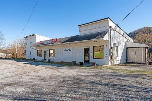

This Property Is For Sale
Property Detail
3199 Northfork Rd
016856
C L DEHART FRM MAP
Commercialnec
Montgomery
A1
Virginia
B and X Area of moderate flood hazard, usually the area between the limits of the 100-year and 500-year floods.
0.61 AC
2025
Blacksburg & Wytheville
2025
Other Market Areas
021300
Blacksburg-Christiansburg-Radford, VA
3,516 SF
NEARBY LISTINGS FOR SALE OR LEASE
-
-
View all Elliston listings for sale on LoopNet.com
DEMOGRAPHICS near 3199 Northfork Rd
1 mile
3 mile
5 mile
2025 Total Population
250
1,584
6,164
2030 Population
252
1,596
6,220
Pop Growth 2025-2030
+ 0.80%
+ 0.76%
+ 0.91%
Average Age
46
45
43
2025 Total Households
100
637
2,484
HH Growth 2025-2030
+ 1.00%
+ 0.94%
+ 1.01%
Median Household Inc
$85,714
$72,793
$67,744
Avg Household Size
2.40
2.50
2.40
2025 Avg HH Vehicles
2.00
2.00
2.00
Median Home Value
$425,000
$282,894
$229,143
Median Year Built
1987
1985
1981
Nearby Places
Map Layers
Map Styles
 Street
 Aerial
Transit
 Traffic
 Biking
Places
Listings with unknown addresses are not visible on the map
- Restaurants
- Banks
- Shops
- Fitness
- Groceries
PUBLIC TRANSPORTATION
AIRPORT
Roanoke/Blacksburg Regional (Woodrum Field)
Drive
Walk
Distance
Roanoke/Blacksburg Regional (Woodrum Field)
39 min
24.5 mi
Freight Ports
Virginia Port Authority - Richmond
Drive
Walk
Distance
Virginia Port Authority - Richmond
241 min
208.3 mi
Nearby Properties
Address
Land Use
TOTAL SIZE
Lot Size
Zoning
Address
Land Use
TOTAL SIZE
Lot Size
Zoning
98,713 SF
0.02 AC
A1
Address
Land Use
TOTAL SIZE
Lot Size
Zoning
20,163 SF
3.78 AC
GB
Address
Land Use
TOTAL SIZE
Lot Size
Zoning
2,953 SF
44.70 AC
A1
Address
Land Use
TOTAL SIZE
Lot Size
Zoning
3,768 SF
36.15 AC
A1
Address
Land Use
TOTAL SIZE
Lot Size
Zoning
1,500 SF
9.84 AC
M1
Address
Land Use
TOTAL SIZE
Lot Size
Zoning
10,545 SF
2.41 AC
A1
Address
Land Use
TOTAL SIZE
Lot Size
Zoning
316.49 AC
A1
Address
Land Use
TOTAL SIZE
Lot Size
Zoning
5,008 SF
25.61 AC
A1
Address
Land Use
TOTAL SIZE
Lot Size
Zoning
1,589 SF
79.11 AC
A1
Address
Land Use
TOTAL SIZE
Lot Size
Zoning
4,497 SF
184.78 AC
A1
Address
Land Use
TOTAL SIZE
Lot Size
Zoning
1,744 SF
380.28 AC
A1
Address
Land Use
TOTAL SIZE
Lot Size
Zoning
3,139 SF
128.95 AC
A1
Address
Land Use
TOTAL SIZE
Lot Size
Zoning
711.49 AC
A1
Address
Land Use
TOTAL SIZE
Lot Size
Zoning
2,304 SF
42 AC
A1
Address
Land Use
TOTAL SIZE
Lot Size
Zoning
4,662 SF
29.95 AC
A1
Address
Land Use
TOTAL SIZE
Lot Size
Zoning
Address
Land Use
TOTAL SIZE
Lot Size
Zoning
2.89 AC
GB
Address
Land Use
TOTAL SIZE
Lot Size
Zoning
1,500 SF
76.93 AC
A1
Address
Land Use
TOTAL SIZE
Lot Size
Zoning
2,616 SF
30.63 AC
A1
Address
Land Use
TOTAL SIZE
Lot Size
Zoning
9,856 SF
7 AC
A1
Address
Land Use
TOTAL SIZE
Lot Size
Zoning
4,128 SF
22.21 AC
A1
Address
Land Use
TOTAL SIZE
Lot Size
Zoning
9,968 SF
0.67 AC
R2
Address
Land Use
TOTAL SIZE
Lot Size
Zoning
3,030 SF
0.43 AC
GB
Address
Land Use
TOTAL SIZE
Lot Size
Zoning
1,798 SF
1.16 AC
GB
Address
Land Use
TOTAL SIZE
Lot Size
Zoning
3,288 SF
61.89 AC
A1
Address
Land Use
TOTAL SIZE
Lot Size
Zoning
3,674 SF
73.18 AC
A1
Address
Land Use
TOTAL SIZE
Lot Size
Zoning
1,904 SF
137.04 AC
A1
Address
Land Use
TOTAL SIZE
Lot Size
Zoning
3,600 SF
4.09 AC
A1
Address
Land Use
TOTAL SIZE
Lot Size
Zoning
1,476 SF
127.83 AC
A1
The World's #1 Commercial Real Estate Marketplace
Connect with us
© 2026 CoStar Group
The information above has been obtained from sources believed reliable. While we do not doubt its accuracy we have not verified it and make no guarantee, warranty or representation about it. It is your responsibility to independently confirm its accuracy and completeness. Any projections, opinions, assumptions, or estimates used are for example only and do not represent the current or future performance of the property. The value of this transaction to you depends on tax and other factors which should be evaluated by your tax, financial, and legal advisors. You and your advisors should conduct a careful, independent investigation of the property to determine to your satisfaction the suitability of the property for your needs.