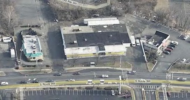
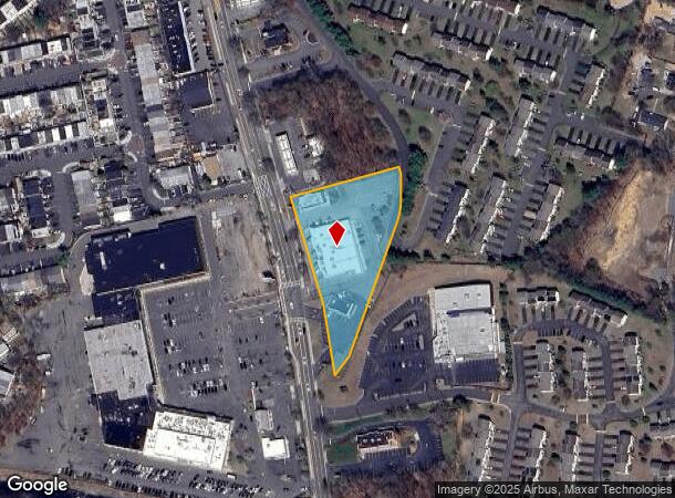
Property Record
32 S Route 9W S, West Haverstraw, NY 10993
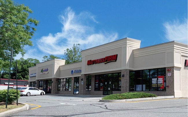
Current Lease Availabilities
NEARBY LISTINGS FOR SALE OR LEASE
Property Detail
32 S Route 9W S
New York-Jersey City-White Plains, NY-NJ
Fairgrounds Revised
392203-026-007-0004-001-000-0000
31.-3-1
Storebuilding
Rockland
X
New York
36087C0103G
1.0
2023
1.82 AC
2024
Clarkstown
010602
Northern New Jersey
19,982 SF
DEMOGRAPHICS near 32 S Route 9W S
1 Mile
3 Mile
5 Mile
2024 Total Population
16,469
52,199
103,680
2029 Population
16,198
51,684
102,923
Pop Growth 2024-2029
(1.65%)
(0.99%)
(0.73%)
Average Age
39
40
41
2024 Total Households
5,225
17,293
34,235
HH Growth 2024-2029
(1.67%)
(0.97%)
(0.86%)
Median Household Inc
$70,485
$95,404
$107,455
Avg Household Size
3.00
2.90
2.90
2024 Avg HH Vehicles
2.00
2.00
2.00
Median Home Value
$305,620
$401,776
$478,876
Median Year Built
1968
1972
1971
Nearby Places
- Restaurants
- Banks
- Shops
- Fitness
- Groceries
PUBLIC TRANSPORTATION
COMMUTER RAIL
Spring Valley (Pascack Valley Line - NJ Transit Commuter Rail (NJ Transit))
DRIVE
WALK
Distance
Spring Valley (Pascack Valley Line - NJ Transit Commuter Rail (NJ Transit))
16 min
9.2 mi
AIRPORT
New York Stewart International
DRIVE
WALK
Distance
New York Stewart International
43 min
28.7 mi
Westchester County
DRIVE
WALK
Distance
Westchester County
40 min
28.9 mi
LaGuardia
DRIVE
WALK
Distance
LaGuardia
59 min
41.6 mi
Freight Ports
Maher Terminal
DRIVE
WALK
Distance
Maher Terminal
65 min
45.1 mi
Nearby Properties
Address
Land Use
TOTAL SIZE
Lot Size
Zoning
Address
Land Use
TOTAL SIZE
Lot Size
Zoning
620,500 SF
63.50 AC
925
Address
Land Use
TOTAL SIZE
Lot Size
Zoning
196,017 SF
12.08 AC
962
Address
Land Use
TOTAL SIZE
Lot Size
Zoning
174,000 SF
20.60 AC
915
Address
Land Use
TOTAL SIZE
Lot Size
Zoning
31,056 SF
14.70 AC
940
Address
Land Use
TOTAL SIZE
Lot Size
Zoning
178,908 SF
9.70 AC
361
Address
Land Use
TOTAL SIZE
Lot Size
Zoning
94,452 SF
10.71 AC
164
Address
Land Use
TOTAL SIZE
Lot Size
Zoning
129,170 SF
29.99 AC
911
Address
Land Use
TOTAL SIZE
Lot Size
Zoning
Address
Land Use
TOTAL SIZE
Lot Size
Zoning
113,413 SF
17.77 AC
962
Address
Land Use
TOTAL SIZE
Lot Size
Zoning
187,664 SF
7.30 AC
304
Address
Land Use
TOTAL SIZE
Lot Size
Zoning
105,994 SF
2.02 AC
140
Address
Land Use
TOTAL SIZE
Lot Size
Zoning
131,581 SF
2.62 AC
140
Address
Land Use
TOTAL SIZE
Lot Size
Zoning
26.80 AC
964
Address
Land Use
TOTAL SIZE
Lot Size
Zoning
79,449 SF
10.40 AC
915
Address
Land Use
TOTAL SIZE
Lot Size
Zoning
106,416 SF
7.74 AC
915
Address
Land Use
TOTAL SIZE
Lot Size
Zoning
49,212 SF
11.40 AC
915
Address
Land Use
TOTAL SIZE
Lot Size
Zoning
46,164 SF
0.52 AC
168
Address
Land Use
TOTAL SIZE
Lot Size
Zoning
4.80 AC
361
Address
Land Use
TOTAL SIZE
Lot Size
Zoning
64,432 SF
11.98 AC
302
Address
Land Use
TOTAL SIZE
Lot Size
Zoning
62,140 SF
1.92 AC
161
Address
Land Use
TOTAL SIZE
Lot Size
Zoning
64,800 SF
7.08 AC
304
Address
Land Use
TOTAL SIZE
Lot Size
Zoning
8.40 AC
303
Address
Land Use
TOTAL SIZE
Lot Size
Zoning
60,012 SF
4.50 AC
301
Address
Land Use
TOTAL SIZE
Lot Size
Zoning
39,499 SF
5.90 AC
110
Address
Land Use
TOTAL SIZE
Lot Size
Zoning
26,847 SF
131.60 AC
925
Address
Land Use
TOTAL SIZE
Lot Size
Zoning
118,089 SF
9.60 AC
915
Address
Land Use
TOTAL SIZE
Lot Size
Zoning
181,393 SF
21.55 AC
166
Address
Land Use
TOTAL SIZE
Lot Size
Zoning
34,938 SF
0.43 AC
962
Address
Land Use
TOTAL SIZE
Lot Size
Zoning
Address
Land Use
TOTAL SIZE
Lot Size
Zoning
28,860 SF
3.60 AC
304
The World's #1 Commercial Real Estate Marketplace
Connect with us
© 2025 CoStar Group
The information above has been obtained from sources believed reliable. While we do not doubt its accuracy we have not verified it and make no guarantee, warranty or representation about it. It is your responsibility to independently confirm its accuracy and completeness. Any projections, opinions, assumptions, or estimates used are for example only and do not represent the current or future performance of the property. The value of this transaction to you depends on tax and other factors which should be evaluated by your tax, financial, and legal advisors. You and your advisors should conduct a careful, independent investigation of the property to determine to your satisfaction the suitability of the property for your needs.