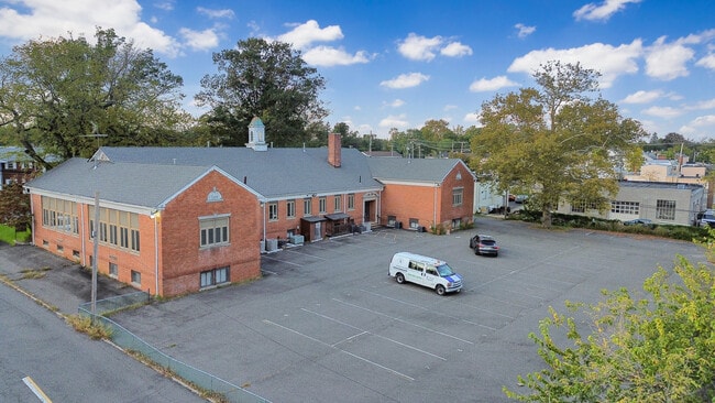
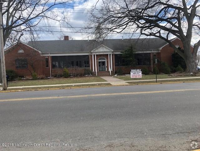
Property Record
32 Broad St, Freehold, NJ 07728


Property Detail
32 Broad St
16-00035-0000-00015
MONMOUTH
Officebuilding
New Jersey
OB0
15
B and X Area of moderate flood hazard, usually the area between the limits of the 100-year and 500-year floods.
0.99 AC
2024
Western Monmouth
2025
Northern New Jersey
810501
Lakewood-New Brunswick, NJ
15,224 SF
NEARBY LISTINGS FOR SALE OR LEASE
DEMOGRAPHICS near 32 Broad St
1 mile
3 mile
5 mile
2025 Total Population
13,632
46,747
100,049
2030 Population
13,477
46,304
99,137
Pop Growth 2025-2030
(1.14%)
(0.95%)
(0.91%)
Average Age
38
41
42
2025 Total Households
4,544
16,145
34,737
HH Growth 2025-2030
(1.39%)
(1.18%)
(1.11%)
Median Household Inc
$86,390
$119,812
$136,193
Avg Household Size
2.90
2.80
2.80
2025 Avg HH Vehicles
2.00
2.00
2.00
Median Home Value
$423,268
$590,494
$642,686
Median Year Built
1970
1979
1983
Nearby Places
Map Layers
Map Styles
 Street
 Aerial
Layers
 Traffic
 Biking
Places
Listings with unknown addresses are not visible on the map
- Restaurants
- Banks
- Shops
- Fitness
- Groceries
SALE & LEASE HISTORY
LISTING DATE
SALE/LEASE

Sep 25, 2016
For Lease
Oct 05, 2023
For Sale
Oct 03, 2019
For Lease
Nov 30, 2018
For Lease
Nov 27, 2017
For Sale
Nov 27, 2017
For Lease
Mar 06, 2018
For Sale
Jun 08, 2022
For Sale
Feb 28, 2019
For Lease
Feb 28, 2019
For Sale
Nearby Properties
Address
Land Use
TOTAL SIZE
Lot Size
Zoning
Address
Land Use
TOTAL SIZE
Lot Size
Zoning
825,686 SF
151.47 AC
C50
Address
Land Use
TOTAL SIZE
Lot Size
Zoning
52.16 AC
H-1
Address
Land Use
TOTAL SIZE
Lot Size
Zoning
4,649 SF
40.27 AC
ML-7
Address
Land Use
TOTAL SIZE
Lot Size
Zoning
56.99 AC
C50
Address
Land Use
TOTAL SIZE
Lot Size
Zoning
904,310 SF
85.13 AC
M2M1
Address
Land Use
TOTAL SIZE
Lot Size
Zoning
285,037 SF
40.82 AC
H-1
Address
Land Use
TOTAL SIZE
Lot Size
Zoning
15.69 AC
HMUD
Address
Land Use
TOTAL SIZE
Lot Size
Zoning
267,666 SF
29.06 AC
M-1
Address
Land Use
TOTAL SIZE
Lot Size
Zoning
73,884 SF
37.60 AC
R-40
Address
Land Use
TOTAL SIZE
Lot Size
Zoning
25.27 AC
C1
Address
Land Use
TOTAL SIZE
Lot Size
Zoning
114,738 SF
19.02 AC
M-1
Address
Land Use
TOTAL SIZE
Lot Size
Zoning
241,399 SF
69.89 AC
R-40
Address
Land Use
TOTAL SIZE
Lot Size
Zoning
42,982 SF
118.30 AC
R-40
Address
Land Use
TOTAL SIZE
Lot Size
Zoning
2.91 AC
RCR
Address
Land Use
TOTAL SIZE
Lot Size
Zoning
278,199 SF
6.92 AC
SF05
Address
Land Use
TOTAL SIZE
Lot Size
Zoning
246,459 SF
60.38 AC
ROL
Address
Land Use
TOTAL SIZE
Lot Size
Zoning
81,690 SF
42.46 AC
RMZ-
Address
Land Use
TOTAL SIZE
Lot Size
Zoning
13,730 SF
19.29 AC
OB01
Address
Land Use
TOTAL SIZE
Lot Size
Zoning
19.02 AC
HD
Address
Land Use
TOTAL SIZE
Lot Size
Zoning
176,661 SF
13.04 AC
OB01
Address
Land Use
TOTAL SIZE
Lot Size
Zoning
138.38 AC
R-E
Address
Land Use
TOTAL SIZE
Lot Size
Zoning
82,872 SF
25.58 AC
B-10
Address
Land Use
TOTAL SIZE
Lot Size
Zoning
21 AC
R-40
Address
Land Use
TOTAL SIZE
Lot Size
Zoning
23,260 SF
17.90 AC
B-10
Address
Land Use
TOTAL SIZE
Lot Size
Zoning
48,451 SF
12.17 AC
B-10
Address
Land Use
TOTAL SIZE
Lot Size
Zoning
200,294 SF
12 AC
R10
Address
Land Use
TOTAL SIZE
Lot Size
Zoning
93.79 AC
R-60
Address
Land Use
TOTAL SIZE
Lot Size
Zoning
12.15 AC
P-1
Address
Land Use
TOTAL SIZE
Lot Size
Zoning
7,112 SF
10.01 AC
CM3A
Address
Land Use
TOTAL SIZE
Lot Size
Zoning
13.21 AC
OB01
The World's #1 Commercial Real Estate Marketplace
Connect with us
© 2026 CoStar Group
The information above has been obtained from sources believed reliable. While we do not doubt its accuracy we have not verified it and make no guarantee, warranty or representation about it. It is your responsibility to independently confirm its accuracy and completeness. Any projections, opinions, assumptions, or estimates used are for example only and do not represent the current or future performance of the property. The value of this transaction to you depends on tax and other factors which should be evaluated by your tax, financial, and legal advisors. You and your advisors should conduct a careful, independent investigation of the property to determine to your satisfaction the suitability of the property for your needs.