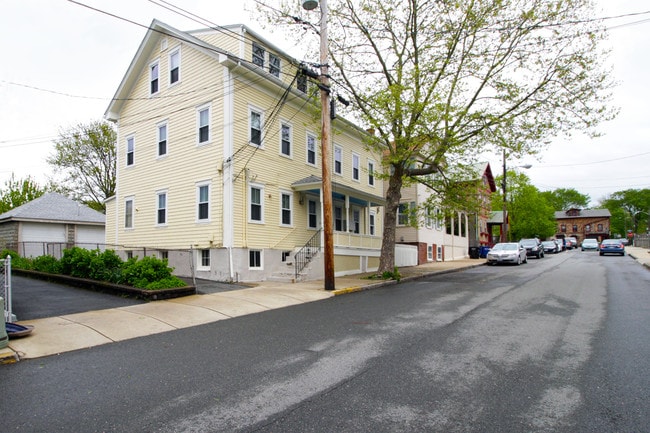
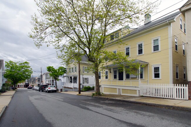
Property Record
32 Dearborn St, Newport, RI 02840

Property Detail
32 Dearborn St
Apartment
Newport
R10
Rhode Island
B and X Area of moderate flood hazard, usually the area between the limits of the 100-year and 500-year floods.
0.12 AC
2025
Newport
2025
Providence
041000
Providence-Warwick, RI-MA
3,240 SF
NEWP-000032-000000-000199
NEARBY LISTINGS FOR SALE OR LEASE
DEMOGRAPHICS near 32 Dearborn St
1 mile
3 mile
5 mile
2025 Total Population
10,541
31,691
46,520
2030 Population
10,288
30,934
45,990
Pop Growth 2025-2030
(2.40%)
(2.39%)
(1.14%)
Average Age
45
44
44
2025 Total Households
4,723
13,600
19,913
HH Growth 2025-2030
(1.80%)
(1.74%)
(2.13%)
Median Household Inc
$97,027
$89,131
$95,949
Avg Household Size
1.90
2.10
2.10
2025 Avg HH Vehicles
1.00
2.00
2.00
Median Home Value
$890,624
$792,729
$737,471
Median Year Built
1947
1950
1960
Nearby Places
Map Layers
Map Styles
 Street
 Aerial
Layers
 Traffic
 Biking
Places
Listings with unknown addresses are not visible on the map
- Restaurants
- Banks
- Shops
- Fitness
- Groceries
PUBLIC TRANSPORTATION
AIRPORT
Rhode Island Tf Green International
Drive
Walk
Distance
Rhode Island Tf Green International
47 min
29.0 mi
Freight Ports
Port of Davisville, RI
Drive
Walk
Distance
Port of Davisville, RI
33 min
17.8 mi
SALE & LEASE HISTORY
LISTING DATE
SALE/LEASE

Jul 10, 2019
For Sale
Nearby Properties
Address
Land Use
TOTAL SIZE
Lot Size
Zoning
Address
Land Use
TOTAL SIZE
Lot Size
Zoning
60.03 AC
R40
Address
Land Use
TOTAL SIZE
Lot Size
Zoning
264,032 SF
3.73 AC
GB
Address
Land Use
TOTAL SIZE
Lot Size
Zoning
237,976 SF
8.99 AC
WB
Address
Land Use
TOTAL SIZE
Lot Size
Zoning
141,371 SF
12.59 AC
R60
Address
Land Use
TOTAL SIZE
Lot Size
Zoning
143,311 SF
2.94 AC
GB
Address
Land Use
TOTAL SIZE
Lot Size
Zoning
63,510 SF
13.17 AC
R60
Address
Land Use
TOTAL SIZE
Lot Size
Zoning
249,902 SF
27.88 AC
UV
Address
Land Use
TOTAL SIZE
Lot Size
Zoning
118,890 SF
35.60 AC
R40
Address
Land Use
TOTAL SIZE
Lot Size
Zoning
104,307 SF
3.58 AC
R60
Address
Land Use
TOTAL SIZE
Lot Size
Zoning
45,074 SF
5.65 AC
R60
Address
Land Use
TOTAL SIZE
Lot Size
Zoning
76,534 SF
5.29 AC
WB
Address
Land Use
TOTAL SIZE
Lot Size
Zoning
86,091 SF
6.50 AC
CI
Address
Land Use
TOTAL SIZE
Lot Size
Zoning
81,080 SF
5.35 AC
R60
Address
Land Use
TOTAL SIZE
Lot Size
Zoning
74,403 SF
8.56 AC
R60
Address
Land Use
TOTAL SIZE
Lot Size
Zoning
158,333 SF
1.81 AC
R10
Address
Land Use
TOTAL SIZE
Lot Size
Zoning
217,212 SF
10.46 AC
R10
Address
Land Use
TOTAL SIZE
Lot Size
Zoning
172,320 SF
10.14 AC
R10
Address
Land Use
TOTAL SIZE
Lot Size
Zoning
16,051 SF
9 AC
R60
Address
Land Use
TOTAL SIZE
Lot Size
Zoning
37,484 SF
10.45 AC
R60
Address
Land Use
TOTAL SIZE
Lot Size
Zoning
21,977 SF
36.71 AC
R120
Address
Land Use
TOTAL SIZE
Lot Size
Zoning
108,365 SF
5.15 AC
R10
Address
Land Use
TOTAL SIZE
Lot Size
Zoning
41,145 SF
9.33 AC
R120
Address
Land Use
TOTAL SIZE
Lot Size
Zoning
36,984 SF
10 AC
R10
Address
Land Use
TOTAL SIZE
Lot Size
Zoning
26,975 SF
8.85 AC
R60
Address
Land Use
TOTAL SIZE
Lot Size
Zoning
151,202 SF
15.98 AC
PA
Address
Land Use
TOTAL SIZE
Lot Size
Zoning
24,868 SF
4.36 AC
R60
Address
Land Use
TOTAL SIZE
Lot Size
Zoning
50,220 SF
8.83 AC
TM
Address
Land Use
TOTAL SIZE
Lot Size
Zoning
24 AC
R120
Address
Land Use
TOTAL SIZE
Lot Size
Zoning
38,760 SF
7.75 AC
R60
Address
Land Use
TOTAL SIZE
Lot Size
Zoning
45,283 SF
1.66 AC
WB
The World's #1 Commercial Real Estate Marketplace
Connect with us
© 2026 CoStar Group
The information above has been obtained from sources believed reliable. While we do not doubt its accuracy we have not verified it and make no guarantee, warranty or representation about it. It is your responsibility to independently confirm its accuracy and completeness. Any projections, opinions, assumptions, or estimates used are for example only and do not represent the current or future performance of the property. The value of this transaction to you depends on tax and other factors which should be evaluated by your tax, financial, and legal advisors. You and your advisors should conduct a careful, independent investigation of the property to determine to your satisfaction the suitability of the property for your needs.