Property Record
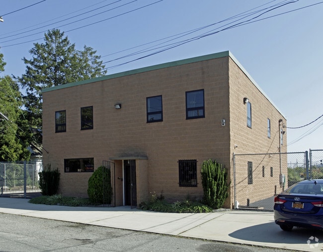
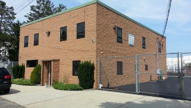
32 Holman Blvd, Hicksville, NY 11801
This Property Is For Sale
NEARBY LISTINGS FOR SALE OR LEASE
Property Detail
32 Holman Blvd
Nassau County-Suffolk County, NY
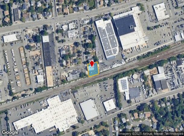
Map Of Manetto Plaza At Hicksville
2489-11-G-00-0188-0
TOWN #3 SCH DIST 017
Officebuilding
Nassau
X
New York
36059C0145G
188
2025
0.28 AC
2025
Eastern Nassau
518900
Long Island (New York)
7,452 SF
DEMOGRAPHICS near 32 Holman Blvd
1 Mile
3 Mile
5 Mile
2024 Total Population
16,237
147,902
328,351
2029 Population
15,825
145,313
322,936
Pop Growth 2024-2029
(2.54%)
(1.75%)
(1.65%)
Average Age
41
41
42
2024 Total Households
4,957
44,997
103,431
HH Growth 2024-2029
(2.62%)
(1.83%)
(1.72%)
Median Household Inc
$116,619
$130,314
$134,335
Avg Household Size
3.10
3.10
3.00
2024 Avg HH Vehicles
2.00
2.00
2.00
Median Home Value
$618,523
$642,739
$659,437
Median Year Built
1955
1955
1955
Nearby Places
- Restaurants
- Banks
- Shops
- Fitness
- Groceries
PUBLIC TRANSPORTATION
COMMUTER RAIL
Hicksville Station (Montauk Branch - Long Island Rail Road, Port Jefferson Branch - Long Island Rail Road, Ronkonkoma Branch - Long Island Rail Road)
DRIVE
WALK
Distance
Hicksville Station (Montauk Branch - Long Island Rail Road, Port Jefferson Branch - Long Island Rail Road, Ronkonkoma Branch - Long Island Rail Road)
1 min
10 min
0.5 mi
Westbury Station (Port Jefferson Branch - Long Island Rail Road)
DRIVE
WALK
Distance
Westbury Station (Port Jefferson Branch - Long Island Rail Road)
6 min
3.1 mi
AIRPORT
John F Kennedy International
DRIVE
WALK
Distance
John F Kennedy International
34 min
20.7 mi
LaGuardia
DRIVE
WALK
Distance
LaGuardia
34 min
22.6 mi
Westchester County
DRIVE
WALK
Distance
Westchester County
64 min
43.0 mi
Freight Ports
NY - Red Hook Container Terminal
DRIVE
WALK
Distance
NY - Red Hook Container Terminal
45 min
30.7 mi
Nearby Properties
Address
Land Use
TOTAL SIZE
Lot Size
Zoning
Address
Land Use
TOTAL SIZE
Lot Size
Zoning
1,027,545 SF
15.65 AC
Address
Land Use
TOTAL SIZE
Lot Size
Zoning
729,696 SF
579.18 AC
Address
Land Use
TOTAL SIZE
Lot Size
Zoning
170,920 SF
27.82 AC
Address
Land Use
TOTAL SIZE
Lot Size
Zoning
Address
Land Use
TOTAL SIZE
Lot Size
Zoning
568,086 SF
21.99 AC
Address
Land Use
TOTAL SIZE
Lot Size
Zoning
1,003,826 SF
84.27 AC
Address
Land Use
TOTAL SIZE
Lot Size
Zoning
469,586 SF
53.14 AC
Address
Land Use
TOTAL SIZE
Lot Size
Zoning
15,825 SF
22.94 AC
Address
Land Use
TOTAL SIZE
Lot Size
Zoning
659,098 SF
34.76 AC
Address
Land Use
TOTAL SIZE
Lot Size
Zoning
384,267 SF
29.25 AC
Address
Land Use
TOTAL SIZE
Lot Size
Zoning
1,068,978 SF
56.12 AC
Address
Land Use
TOTAL SIZE
Lot Size
Zoning
143,519 SF
20.67 AC
Address
Land Use
TOTAL SIZE
Lot Size
Zoning
505,020 SF
58.54 AC
Address
Land Use
TOTAL SIZE
Lot Size
Zoning
432,954 SF
26.25 AC
Address
Land Use
TOTAL SIZE
Lot Size
Zoning
331,084 SF
26.95 AC
Address
Land Use
TOTAL SIZE
Lot Size
Zoning
146,287 SF
48.63 AC
Address
Land Use
TOTAL SIZE
Lot Size
Zoning
197,357 SF
32.05 AC
Address
Land Use
TOTAL SIZE
Lot Size
Zoning
66,602 SF
19.93 AC
Address
Land Use
TOTAL SIZE
Lot Size
Zoning
12,261 SF
12.83 AC
Address
Land Use
TOTAL SIZE
Lot Size
Zoning
60,571 SF
127.50 AC
Address
Land Use
TOTAL SIZE
Lot Size
Zoning
130,994 SF
27.94 AC
Address
Land Use
TOTAL SIZE
Lot Size
Zoning
248,816 SF
26.72 AC
Address
Land Use
TOTAL SIZE
Lot Size
Zoning
98,802 SF
9.70 AC
Address
Land Use
TOTAL SIZE
Lot Size
Zoning
34,500 SF
16 AC
Address
Land Use
TOTAL SIZE
Lot Size
Zoning
393,511 SF
13.07 AC
Address
Land Use
TOTAL SIZE
Lot Size
Zoning
84,714 SF
15.09 AC
Address
Land Use
TOTAL SIZE
Lot Size
Zoning
992,672 SF
37.18 AC
Address
Land Use
TOTAL SIZE
Lot Size
Zoning
219,370 SF
15.31 AC
Address
Land Use
TOTAL SIZE
Lot Size
Zoning
177,109 SF
23.78 AC
Address
Land Use
TOTAL SIZE
Lot Size
Zoning
228,527 SF
4.81 AC
The World's #1 Commercial Real Estate Marketplace
Connect with us
© 2025 CoStar Group
The information above has been obtained from sources believed reliable. While we do not doubt its accuracy we have not verified it and make no guarantee, warranty or representation about it. It is your responsibility to independently confirm its accuracy and completeness. Any projections, opinions, assumptions, or estimates used are for example only and do not represent the current or future performance of the property. The value of this transaction to you depends on tax and other factors which should be evaluated by your tax, financial, and legal advisors. You and your advisors should conduct a careful, independent investigation of the property to determine to your satisfaction the suitability of the property for your needs.