Property Record
32 Main St, Ashaway, RI 02804
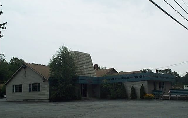

Property Detail
32 Main St
HOPK-000022-000000-000074A
Washington
Commercialbuilding
Rhode Island
RFR8
74a
C and X Area of minimal flood hazard, usually depicted on FIRMs as above the 500-year flood level.
1.38 AC
2025
Washington County
2025
Providence
050702
Providence-Warwick, RI-MA
3,402 SF
NEARBY LISTINGS FOR SALE OR LEASE
DEMOGRAPHICS near 32 Main St
1 mile
3 mile
5 mile
2025 Total Population
1,465
17,846
34,900
2030 Population
1,408
17,177
34,348
Pop Growth 2025-2030
(3.89%)
(3.75%)
(1.58%)
Average Age
44
43
45
2025 Total Households
590
7,623
14,907
HH Growth 2025-2030
(4.24%)
(4.21%)
(1.89%)
Median Household Inc
$104,021
$82,192
$92,857
Avg Household Size
2.40
2.30
2.30
2025 Avg HH Vehicles
2.00
2.00
2.00
Median Home Value
$428,246
$387,688
$425,924
Median Year Built
1970
1963
1971
Nearby Places
Map Layers
Map Styles
 Street
 Aerial
Layers
 Traffic
 Biking
Places
Listings with unknown addresses are not visible on the map
- Restaurants
- Banks
- Shops
- Fitness
- Groceries
PUBLIC TRANSPORTATION
COMMUTER RAIL
Westerly Amtrak Station (Northeast Regional - Amtrak)
Drive
Walk
Distance
Westerly Amtrak Station (Northeast Regional - Amtrak)
4 min
2.7 mi
AIRPORT
Rhode Island Tf Green International
Drive
Walk
Distance
Rhode Island Tf Green International
48 min
34.9 mi
Freight Ports
Port of Davisville, RI
Drive
Walk
Distance
Port of Davisville, RI
50 min
35.2 mi
Nearby Properties
Address
Land Use
TOTAL SIZE
Lot Size
Zoning
Address
Land Use
TOTAL SIZE
Lot Size
Zoning
154,316 SF
4.57 AC
Address
Land Use
TOTAL SIZE
Lot Size
Zoning
14.24 AC
Address
Land Use
TOTAL SIZE
Lot Size
Zoning
96,882 SF
13.12 AC
Address
Land Use
TOTAL SIZE
Lot Size
Zoning
232,164 SF
41 AC
MFG
Address
Land Use
TOTAL SIZE
Lot Size
Zoning
14.71 AC
Address
Land Use
TOTAL SIZE
Lot Size
Zoning
14.04 AC
Address
Land Use
TOTAL SIZE
Lot Size
Zoning
66,003 SF
44.50 AC
GBR-13
Address
Land Use
TOTAL SIZE
Lot Size
Zoning
117,852 SF
19.78 AC
Address
Land Use
TOTAL SIZE
Lot Size
Zoning
0.55 AC
Address
Land Use
TOTAL SIZE
Lot Size
Zoning
40,943 SF
25.78 AC
Address
Land Use
TOTAL SIZE
Lot Size
Zoning
40,705 SF
1.07 AC
Address
Land Use
TOTAL SIZE
Lot Size
Zoning
64,166 SF
12 AC
HI-60
Address
Land Use
TOTAL SIZE
Lot Size
Zoning
47,737 SF
9.96 AC
Address
Land Use
TOTAL SIZE
Lot Size
Zoning
142.05 AC
Address
Land Use
TOTAL SIZE
Lot Size
Zoning
11.40 AC
RFR8
Address
Land Use
TOTAL SIZE
Lot Size
Zoning
46,362 SF
7.43 AC
Address
Land Use
TOTAL SIZE
Lot Size
Zoning
114.16 AC
OS
Address
Land Use
TOTAL SIZE
Lot Size
Zoning
3,000 SF
50.36 AC
HI-60
Address
Land Use
TOTAL SIZE
Lot Size
Zoning
15.58 AC
Address
Land Use
TOTAL SIZE
Lot Size
Zoning
31,288 SF
2.30 AC
Address
Land Use
TOTAL SIZE
Lot Size
Zoning
100,124 SF
14.28 AC
EDD
Address
Land Use
TOTAL SIZE
Lot Size
Zoning
25,252 SF
3.87 AC
CS-5
Address
Land Use
TOTAL SIZE
Lot Size
Zoning
23,642 SF
0.26 AC
Address
Land Use
TOTAL SIZE
Lot Size
Zoning
3.75 AC
Address
Land Use
TOTAL SIZE
Lot Size
Zoning
41,290 SF
11.28 AC
Address
Land Use
TOTAL SIZE
Lot Size
Zoning
70.31 AC
Address
Land Use
TOTAL SIZE
Lot Size
Zoning
40.46 AC
I
Address
Land Use
TOTAL SIZE
Lot Size
Zoning
5.62 AC
Address
Land Use
TOTAL SIZE
Lot Size
Zoning
15,736 SF
15.75 AC
RA-15
Address
Land Use
TOTAL SIZE
Lot Size
Zoning
9,600 SF
2.86 AC
CH
The World's #1 Commercial Real Estate Marketplace
Connect with us
© 2026 CoStar Group
The information above has been obtained from sources believed reliable. While we do not doubt its accuracy we have not verified it and make no guarantee, warranty or representation about it. It is your responsibility to independently confirm its accuracy and completeness. Any projections, opinions, assumptions, or estimates used are for example only and do not represent the current or future performance of the property. The value of this transaction to you depends on tax and other factors which should be evaluated by your tax, financial, and legal advisors. You and your advisors should conduct a careful, independent investigation of the property to determine to your satisfaction the suitability of the property for your needs.