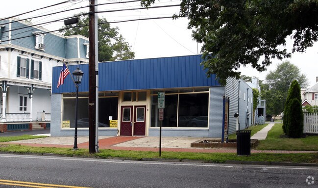
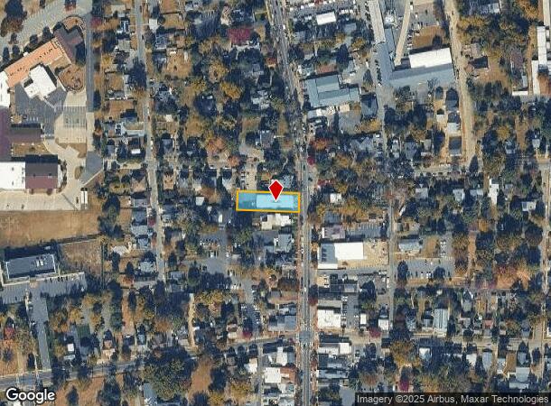
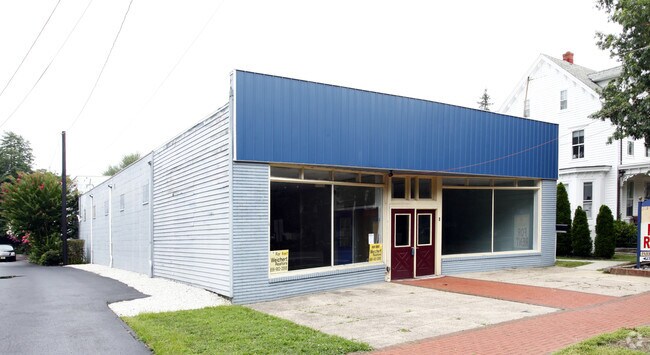
Property Record
32 N Main St, Medford, NJ 08055
NEARBY LISTINGS FOR SALE OR LEASE
Property Detail
32 N Main St
20-01602-0000-00006-02
Plan Of Survey Lot 6.02 Block 1602
Officebuilding
Burlington
X
New Jersey
34005C0264F
6.2
2024
0.28 AC
2025
South Burlington County
703802
Philadelphia
5,998 SF
Philadelphia-Camden-Wilmington, PA-NJ-DE-MD
DEMOGRAPHICS near 32 N Main St
1 Mile
3 Mile
5 Mile
2024 Total Population
5,038
23,970
79,445
2029 Population
5,140
24,409
80,756
Pop Growth 2024-2029
+ 2.02%
+ 1.83%
+ 1.65%
Average Age
45
44
43
2024 Total Households
2,188
9,531
30,335
HH Growth 2024-2029
+ 2.15%
+ 1.93%
+ 1.67%
Median Household Inc
$110,659
$124,707
$128,377
Avg Household Size
2.30
2.50
2.60
2024 Avg HH Vehicles
2.00
2.00
2.00
Median Home Value
$371,037
$386,033
$381,423
Median Year Built
1986
1987
1986
Nearby Places
Map Layers
Map Styles
 Street
 Aerial
- Restaurants
- Banks
- Shops
- Fitness
- Groceries
PUBLIC TRANSPORTATION
AIRPORT
Philadelphia International
DRIVE
WALK
Distance
Philadelphia International
42 min
29.0 mi
Trenton Mercer
DRIVE
WALK
Distance
Trenton Mercer
50 min
34.2 mi
Freight Ports
Port of Philadelphia
DRIVE
WALK
Distance
Port of Philadelphia
27 min
19.1 mi
SALE & LEASE HISTORY
LISTING DATE
SALE/LEASE

Sep 25, 2016
For Lease
Sep 23, 2016
For Sale
Nearby Properties
Address
Land Use
TOTAL SIZE
Lot Size
Zoning
Address
Land Use
TOTAL SIZE
Lot Size
Zoning
50.60 AC
PPE
Address
Land Use
TOTAL SIZE
Lot Size
Zoning
58.48 AC
MD
Address
Land Use
TOTAL SIZE
Lot Size
Zoning
Address
Land Use
TOTAL SIZE
Lot Size
Zoning
2,600 SF
37.38 AC
AH-1
Address
Land Use
TOTAL SIZE
Lot Size
Zoning
3 AC
GMN
Address
Land Use
TOTAL SIZE
Lot Size
Zoning
16.60 AC
Address
Land Use
TOTAL SIZE
Lot Size
Zoning
62.20 AC
GMN
Address
Land Use
TOTAL SIZE
Lot Size
Zoning
13,636 SF
23 AC
HC-1
Address
Land Use
TOTAL SIZE
Lot Size
Zoning
49.38 AC
PPE
Address
Land Use
TOTAL SIZE
Lot Size
Zoning
10,000 SF
10.80 AC
RD-1
Address
Land Use
TOTAL SIZE
Lot Size
Zoning
34.74 AC
PPE/
Address
Land Use
TOTAL SIZE
Lot Size
Zoning
22.74 AC
HC-1
Address
Land Use
TOTAL SIZE
Lot Size
Zoning
57.38 AC
PPE
Address
Land Use
TOTAL SIZE
Lot Size
Zoning
128.02 AC
PPE
Address
Land Use
TOTAL SIZE
Lot Size
Zoning
46.66 AC
AH3
Address
Land Use
TOTAL SIZE
Lot Size
Zoning
9.88 AC
PPE
Address
Land Use
TOTAL SIZE
Lot Size
Zoning
23.70 AC
HM
Address
Land Use
TOTAL SIZE
Lot Size
Zoning
13.74 AC
C-1
Address
Land Use
TOTAL SIZE
Lot Size
Zoning
1,754 SF
10.69 AC
HC-2
Address
Land Use
TOTAL SIZE
Lot Size
Zoning
17.54 AC
PPE
Address
Land Use
TOTAL SIZE
Lot Size
Zoning
19.40 AC
PPE
Address
Land Use
TOTAL SIZE
Lot Size
Zoning
2,400 SF
127.18 AC
INS
Address
Land Use
TOTAL SIZE
Lot Size
Zoning
23,402 SF
2.42 AC
RHO
Address
Land Use
TOTAL SIZE
Lot Size
Zoning
37.51 AC
CC
Address
Land Use
TOTAL SIZE
Lot Size
Zoning
118.26 AC
I3
Address
Land Use
TOTAL SIZE
Lot Size
Zoning
11.14 AC
CC
Address
Land Use
TOTAL SIZE
Lot Size
Zoning
13.50 AC
HC-1
Address
Land Use
TOTAL SIZE
Lot Size
Zoning
1,716 SF
42.56 AC
GMN
Address
Land Use
TOTAL SIZE
Lot Size
Zoning
12,364 SF
11.16 AC
HC-1
Address
Land Use
TOTAL SIZE
Lot Size
Zoning
48.43 AC
HM
The World's #1 Commercial Real Estate Marketplace
Connect with us
© 2025 CoStar Group
The information above has been obtained from sources believed reliable. While we do not doubt its accuracy we have not verified it and make no guarantee, warranty or representation about it. It is your responsibility to independently confirm its accuracy and completeness. Any projections, opinions, assumptions, or estimates used are for example only and do not represent the current or future performance of the property. The value of this transaction to you depends on tax and other factors which should be evaluated by your tax, financial, and legal advisors. You and your advisors should conduct a careful, independent investigation of the property to determine to your satisfaction the suitability of the property for your needs.