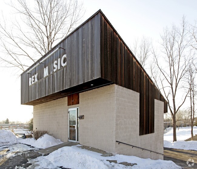
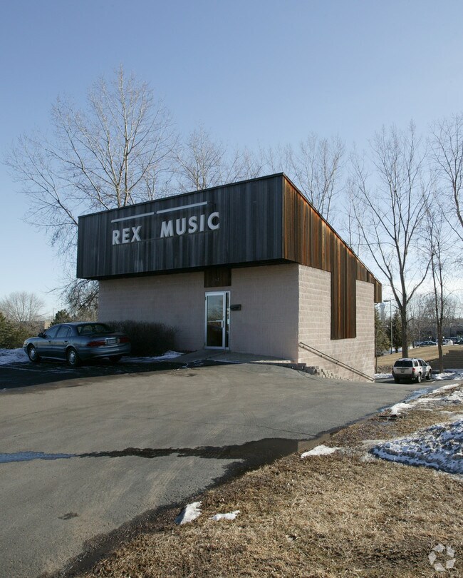
Property Record
32 Thompson Ave E, Saint Paul, MN 55118

Property Detail
32 Thompson Ave E
Minneapolis-St. Paul-Bloomington, MN-WI
CITY CENTER ADDITION 2 2 PT OF LOT 2 BLK 2 LYING BTWN 2 PARR LINE 152 FT & 212 FT W OF W LINE LOT 1 BLK 2 & N OF LINE 50.52 FT S OF S LINE LOT 1 EXT W
42-17800-02-024
DAKOTA
Commercialnec
Minnesota
B and X Area of moderate flood hazard, usually the area between the limits of the 100-year and 500-year floods.
2
2025
0.19 AC
2025
West St Paul
060104
Minneapolis/St Paul
1,904 SF
NEARBY LISTINGS FOR SALE OR LEASE
DEMOGRAPHICS near 32 Thompson Ave E
1 mile
3 mile
5 mile
2025 Total Population
12,188
78,608
251,375
2030 Population
12,576
80,000
253,639
Pop Growth 2025-2030
+ 3.18%
+ 1.77%
+ 0.90%
Average Age
42
40
39
2025 Total Households
5,551
33,195
102,403
HH Growth 2025-2030
+ 3.48%
+ 1.89%
+ 1.00%
Median Household Inc
$67,636
$83,317
$78,322
Avg Household Size
2.10
2.30
2.30
2025 Avg HH Vehicles
2.00
2.00
2.00
Median Home Value
$298,372
$305,977
$320,966
Median Year Built
1972
1968
1963
Nearby Places
Map Layers
Map Styles
 Street
 Aerial
Layers
 Traffic
 Biking
Places
Listings with unknown addresses are not visible on the map
- Restaurants
- Banks
- Shops
- Fitness
- Groceries
PUBLIC TRANSPORTATION
COMMUTER RAIL
St. Paul-Minneapolis (Empire Builder - Amtrak)
Drive
Walk
Distance
St. Paul-Minneapolis (Empire Builder - Amtrak)
9 min
3.9 mi
AIRPORT
Minneapolis-St Paul International/Wold-Chamberlain
Drive
Walk
Distance
Minneapolis-St Paul International/Wold-Chamberlain
17 min
9.2 mi
Freight Ports
Port Milwaukee
Drive
Walk
Distance
Port Milwaukee
369 min
333.3 mi
Nearby Properties
Address
Land Use
TOTAL SIZE
Lot Size
Zoning
Address
Land Use
TOTAL SIZE
Lot Size
Zoning
63.12 AC
Address
Land Use
TOTAL SIZE
Lot Size
Zoning
Address
Land Use
TOTAL SIZE
Lot Size
Zoning
146,085 SF
46.83 AC
Address
Land Use
TOTAL SIZE
Lot Size
Zoning
329,070 SF
5.75 AC
Address
Land Use
TOTAL SIZE
Lot Size
Zoning
445,437 SF
7.80 AC
Address
Land Use
TOTAL SIZE
Lot Size
Zoning
265,736 SF
6.67 AC
Address
Land Use
TOTAL SIZE
Lot Size
Zoning
3.13 AC
Address
Land Use
TOTAL SIZE
Lot Size
Zoning
279,247 SF
1.65 AC
Address
Land Use
TOTAL SIZE
Lot Size
Zoning
247,470 SF
2.21 AC
Address
Land Use
TOTAL SIZE
Lot Size
Zoning
237,685 SF
2.22 AC
Address
Land Use
TOTAL SIZE
Lot Size
Zoning
217,703 SF
3.51 AC
Address
Land Use
TOTAL SIZE
Lot Size
Zoning
233,578 SF
9.56 AC
Address
Land Use
TOTAL SIZE
Lot Size
Zoning
293,970 SF
31.92 AC
Address
Land Use
TOTAL SIZE
Lot Size
Zoning
278,172 SF
1.97 AC
Address
Land Use
TOTAL SIZE
Lot Size
Zoning
282,178 SF
1.86 AC
Address
Land Use
TOTAL SIZE
Lot Size
Zoning
224,944 SF
3.15 AC
Address
Land Use
TOTAL SIZE
Lot Size
Zoning
37,846 SF
2.86 AC
Address
Land Use
TOTAL SIZE
Lot Size
Zoning
222,299 SF
1.61 AC
Address
Land Use
TOTAL SIZE
Lot Size
Zoning
227,436 SF
5.19 AC
Address
Land Use
TOTAL SIZE
Lot Size
Zoning
243,847 SF
5.24 AC
Address
Land Use
TOTAL SIZE
Lot Size
Zoning
228,050 SF
0.32 AC
Address
Land Use
TOTAL SIZE
Lot Size
Zoning
210,540 SF
5.35 AC
Address
Land Use
TOTAL SIZE
Lot Size
Zoning
245,570 SF
2.85 AC
Address
Land Use
TOTAL SIZE
Lot Size
Zoning
156,636 SF
0.77 AC
Address
Land Use
TOTAL SIZE
Lot Size
Zoning
163,985 SF
7.06 AC
Address
Land Use
TOTAL SIZE
Lot Size
Zoning
Address
Land Use
TOTAL SIZE
Lot Size
Zoning
381,395 SF
15.31 AC
Address
Land Use
TOTAL SIZE
Lot Size
Zoning
169,887 SF
17.20 AC
Address
Land Use
TOTAL SIZE
Lot Size
Zoning
Address
Land Use
TOTAL SIZE
Lot Size
Zoning
100,961 SF
2.95 AC
The World's #1 Commercial Real Estate Marketplace
Connect with us
© 2026 CoStar Group
The information above has been obtained from sources believed reliable. While we do not doubt its accuracy we have not verified it and make no guarantee, warranty or representation about it. It is your responsibility to independently confirm its accuracy and completeness. Any projections, opinions, assumptions, or estimates used are for example only and do not represent the current or future performance of the property. The value of this transaction to you depends on tax and other factors which should be evaluated by your tax, financial, and legal advisors. You and your advisors should conduct a careful, independent investigation of the property to determine to your satisfaction the suitability of the property for your needs.