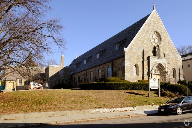
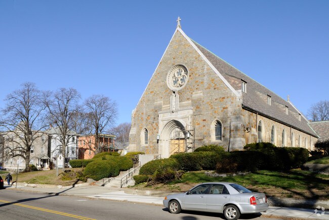
Property Record
32 Walk Hill St, Jamaica Plain, MA 02130
NEARBY LISTINGS FOR SALE OR LEASE
-
-
-
No Photo
-
View all Jamaica Plain listings for sale on LoopNet.com
Property Detail
32 Walk Hill St
Religious
Suffolk
X
Massachusetts
25025C0086G
1.32 AC
0
South Suffolk County
2025
Boston
120400
Boston-Cambridge-Newton, MA-NH
14,267 SF
JAMA-000000-000019-004604
DEMOGRAPHICS near 32 Walk Hill St
1 Mile
3 Mile
5 Mile
2024 Total Population
20,217
290,098
728,572
2029 Population
19,049
274,644
700,448
Pop Growth 2024-2029
(5.78%)
(5.33%)
(3.86%)
Average Age
40
39
38
2024 Total Households
8,314
108,692
290,269
HH Growth 2024-2029
(6.37%)
(5.90%)
(4.24%)
Median Household Inc
$93,616
$75,686
$87,902
Avg Household Size
2.30
2.50
2.30
2024 Avg HH Vehicles
1.00
1.00
1.00
Median Home Value
$672,676
$679,145
$764,857
Median Year Built
1948
1948
1949
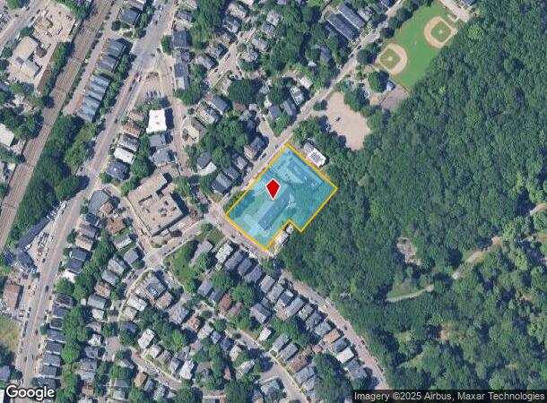
Nearby Places
Map Layers
Map Styles
 Street
 Aerial
- Restaurants
- Banks
- Shops
- Fitness
- Groceries
PUBLIC TRANSPORTATION
TRANSIT/SUBWAY
Forest Hills Station (Orange Line - Massachusetts Bay Transportation Authority Subway (The T))
DRIVE
WALK
Distance
Forest Hills Station (Orange Line - Massachusetts Bay Transportation Authority Subway (The T))
1 min
9 min
0.5 mi
COMMUTER RAIL
Forest Hills (Needham Line - Massachusetts Bay Transportation Authority Commuter Rail (Purple Line))
DRIVE
WALK
Distance
Forest Hills (Needham Line - Massachusetts Bay Transportation Authority Commuter Rail (Purple Line))
1 min
9 min
0.5 mi
Roslindale Village (Needham Line - Massachusetts Bay Transportation Authority Commuter Rail (Purple Line))
DRIVE
WALK
Distance
Roslindale Village (Needham Line - Massachusetts Bay Transportation Authority Commuter Rail (Purple Line))
5 min
1.8 mi
AIRPORT
General Edward Lawrence Logan International
DRIVE
WALK
Distance
General Edward Lawrence Logan International
17 min
8.7 mi
Freight Ports
Port of Boston
DRIVE
WALK
Distance
Port of Boston
16 min
7.0 mi
Nearby Properties
Address
Land Use
TOTAL SIZE
Lot Size
Zoning
Address
Land Use
TOTAL SIZE
Lot Size
Zoning
909,764 SF
25.13 AC
E
Address
Land Use
TOTAL SIZE
Lot Size
Zoning
254,208 SF
3.83 AC
E
Address
Land Use
TOTAL SIZE
Lot Size
Zoning
262,120 SF
0.62 AC
C
Address
Land Use
TOTAL SIZE
Lot Size
Zoning
249,135 SF
1.99 AC
RC
Address
Land Use
TOTAL SIZE
Lot Size
Zoning
268,675 SF
1.72 AC
I
Address
Land Use
TOTAL SIZE
Lot Size
Zoning
147,997 SF
2.03 AC
GMR2
Address
Land Use
TOTAL SIZE
Lot Size
Zoning
146,751 SF
3.39 AC
E
Address
Land Use
TOTAL SIZE
Lot Size
Zoning
317,049 SF
11.22 AC
M05
Address
Land Use
TOTAL SIZE
Lot Size
Zoning
428,271 SF
9.65 AC
E
Address
Land Use
TOTAL SIZE
Lot Size
Zoning
14.59 AC
S40
Address
Land Use
TOTAL SIZE
Lot Size
Zoning
203,252 SF
236.88 AC
S40
Address
Land Use
TOTAL SIZE
Lot Size
Zoning
139,965 SF
9.27 AC
E
Address
Land Use
TOTAL SIZE
Lot Size
Zoning
45,000 SF
14.30 AC
E
Address
Land Use
TOTAL SIZE
Lot Size
Zoning
163,364 SF
3.08 AC
O10
Address
Land Use
TOTAL SIZE
Lot Size
Zoning
351,680 SF
4.01 AC
RC
Address
Land Use
TOTAL SIZE
Lot Size
Zoning
25,744 SF
35.80 AC
S40
Address
Land Use
TOTAL SIZE
Lot Size
Zoning
179.13 AC
E
Address
Land Use
TOTAL SIZE
Lot Size
Zoning
5,119 SF
119.98 AC
S15
Address
Land Use
TOTAL SIZE
Lot Size
Zoning
103,544 SF
0.61 AC
E
Address
Land Use
TOTAL SIZE
Lot Size
Zoning
1,940 SF
58.17 AC
E
Address
Land Use
TOTAL SIZE
Lot Size
Zoning
240.18 AC
E
Address
Land Use
TOTAL SIZE
Lot Size
Zoning
43,880 SF
0.68 AC
E
Address
Land Use
TOTAL SIZE
Lot Size
Zoning
332,366 SF
4.86 AC
E
Address
Land Use
TOTAL SIZE
Lot Size
Zoning
728,348 SF
11.71 AC
C
Address
Land Use
TOTAL SIZE
Lot Size
Zoning
273,051 SF
5.41 AC
E
Address
Land Use
TOTAL SIZE
Lot Size
Zoning
94,995 SF
0.38 AC
E
Address
Land Use
TOTAL SIZE
Lot Size
Zoning
228,215 SF
2.44 AC
RC
Address
Land Use
TOTAL SIZE
Lot Size
Zoning
18,070 SF
119.45 AC
E
Address
Land Use
TOTAL SIZE
Lot Size
Zoning
526,040 SF
27.79 AC
E
Address
Land Use
TOTAL SIZE
Lot Size
Zoning
103,125 SF
0.42 AC
I(EI
The World's #1 Commercial Real Estate Marketplace
Connect with us
© 2025 CoStar Group
The information above has been obtained from sources believed reliable. While we do not doubt its accuracy we have not verified it and make no guarantee, warranty or representation about it. It is your responsibility to independently confirm its accuracy and completeness. Any projections, opinions, assumptions, or estimates used are for example only and do not represent the current or future performance of the property. The value of this transaction to you depends on tax and other factors which should be evaluated by your tax, financial, and legal advisors. You and your advisors should conduct a careful, independent investigation of the property to determine to your satisfaction the suitability of the property for your needs.