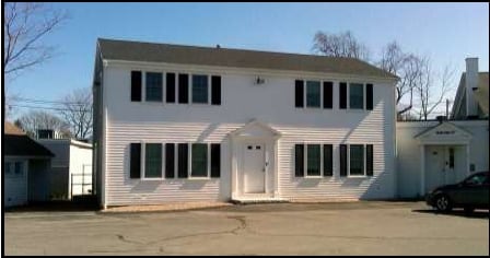
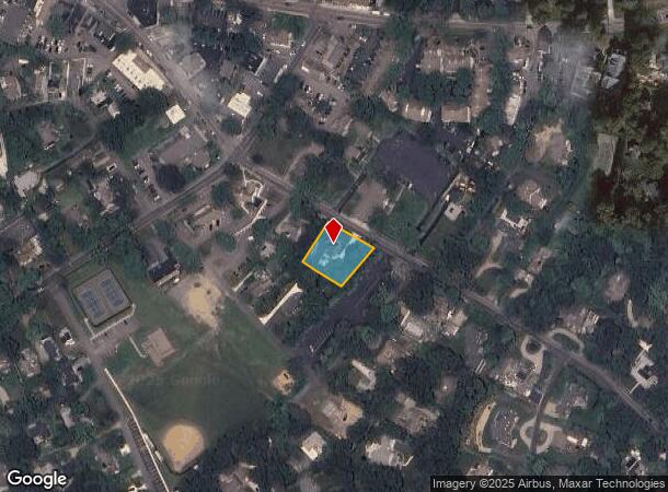
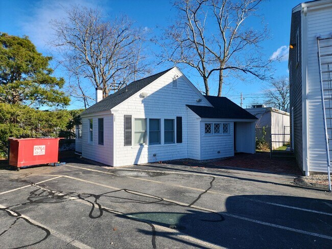
Property Record
91 Wianno Ave, Osterville, MA 02655

Current Lease Availabilities
NEARBY LISTINGS FOR SALE OR LEASE
Property Detail
91 Wianno Ave
OSTE-000141-000000-000001
Barnstable
Sfr
Massachusetts
X
1
25001C0544J
0.40 AC
2025
Cape Cod
2025
Other Market Areas
013002
Barnstable Town, MA
2,710 SF
DEMOGRAPHICS near 91 Wianno Ave
1 mile
3 mile
5 mile
2024 Total Population
2,423
12,840
41,641
2029 Population
2,653
13,295
42,409
Pop Growth 2024-2029
+ 9.49%
+ 3.54%
+ 1.84%
Average Age
54
50
47
2024 Total Households
1,202
5,619
17,346
HH Growth 2024-2029
+ 9.32%
+ 3.59%
+ 1.77%
Median Household Inc
$107,863
$107,656
$90,051
Avg Household Size
2.00
2.20
2.30
2024 Avg HH Vehicles
2.00
2.00
2.00
Median Home Value
$888,690
$584,054
$472,158
Median Year Built
1981
1978
1980
Nearby Places
Map Layers
Map Styles
 Street
 Aerial
Transit
 Traffic
 Biking
Places
Listings with unknown addresses are not visible on the map
- Restaurants
- Banks
- Shops
- Fitness
- Groceries
PUBLIC TRANSPORTATION
COMMUTER RAIL
Drive
Walk
Distance
14 min
7.2 mi
AIRPORT
Martha's Vineyard
Drive
Walk
Distance
Martha's Vineyard
97 min
34.7 mi
Freight Ports
Port of New Bedford Harbor
Drive
Walk
Distance
Port of New Bedford Harbor
68 min
47.1 mi
Nearby Properties
Address
Land Use
TOTAL SIZE
Lot Size
Zoning
Address
Land Use
TOTAL SIZE
Lot Size
Zoning
Address
Land Use
TOTAL SIZE
Lot Size
Zoning
3.28 AC
RF
Address
Land Use
TOTAL SIZE
Lot Size
Zoning
79,282 SF
43.70 AC
RC;BA
Address
Land Use
TOTAL SIZE
Lot Size
Zoning
2.84 AC
RF
Address
Land Use
TOTAL SIZE
Lot Size
Zoning
10,699 SF
2.66 AC
RF
Address
Land Use
TOTAL SIZE
Lot Size
Zoning
11,641 SF
11.20 AC
RF
Address
Land Use
TOTAL SIZE
Lot Size
Zoning
6.44 AC
RF
Address
Land Use
TOTAL SIZE
Lot Size
Zoning
6,460 SF
9 AC
RF
Address
Land Use
TOTAL SIZE
Lot Size
Zoning
2 AC
RF
Address
Land Use
TOTAL SIZE
Lot Size
Zoning
6,423 SF
4.15 AC
RF
Address
Land Use
TOTAL SIZE
Lot Size
Zoning
4.66 AC
R
Address
Land Use
TOTAL SIZE
Lot Size
Zoning
4.62 AC
1
Address
Land Use
TOTAL SIZE
Lot Size
Zoning
8,116 SF
1.68 AC
RF
Address
Land Use
TOTAL SIZE
Lot Size
Zoning
10,445 SF
2.74 AC
RF
Address
Land Use
TOTAL SIZE
Lot Size
Zoning
10,566 SF
2.23 AC
1
Address
Land Use
TOTAL SIZE
Lot Size
Zoning
600 SF
14.90 AC
Address
Land Use
TOTAL SIZE
Lot Size
Zoning
9,002 SF
4.41 AC
RF
Address
Land Use
TOTAL SIZE
Lot Size
Zoning
4,777 SF
1.44 AC
RF
Address
Land Use
TOTAL SIZE
Lot Size
Zoning
6,059 SF
0.18 AC
RF
Address
Land Use
TOTAL SIZE
Lot Size
Zoning
2.72 AC
1
Address
Land Use
TOTAL SIZE
Lot Size
Zoning
10,513 SF
2.52 AC
RC;RF-
Address
Land Use
TOTAL SIZE
Lot Size
Zoning
10,440 SF
3.33 AC
RF
Address
Land Use
TOTAL SIZE
Lot Size
Zoning
9,541 SF
1.94 AC
RF
Address
Land Use
TOTAL SIZE
Lot Size
Zoning
6,987 SF
2.02 AC
1
Address
Land Use
TOTAL SIZE
Lot Size
Zoning
10,772 SF
6.48 AC
RF
Address
Land Use
TOTAL SIZE
Lot Size
Zoning
8,929 SF
1.87 AC
RF
Address
Land Use
TOTAL SIZE
Lot Size
Zoning
3,524 SF
10.70 AC
RD;RC
Address
Land Use
TOTAL SIZE
Lot Size
Zoning
4 AC
RF
Address
Land Use
TOTAL SIZE
Lot Size
Zoning
7,006 SF
2.17 AC
RF
Address
Land Use
TOTAL SIZE
Lot Size
Zoning
73,621 SF
9.91 AC
RC;HB
The World's #1 Commercial Real Estate Marketplace
Connect with us
© 2026 CoStar Group
The information above has been obtained from sources believed reliable. While we do not doubt its accuracy we have not verified it and make no guarantee, warranty or representation about it. It is your responsibility to independently confirm its accuracy and completeness. Any projections, opinions, assumptions, or estimates used are for example only and do not represent the current or future performance of the property. The value of this transaction to you depends on tax and other factors which should be evaluated by your tax, financial, and legal advisors. You and your advisors should conduct a careful, independent investigation of the property to determine to your satisfaction the suitability of the property for your needs.