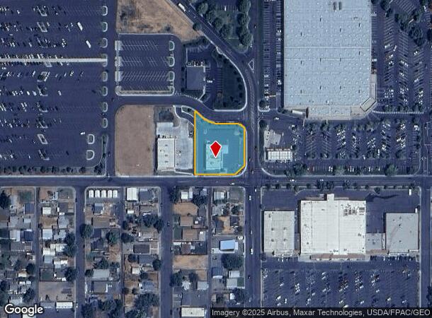
Property Record
320 5Th St, Clarkston, WA 99403
NEARBY LISTINGS FOR SALE OR LEASE
Property Detail
320 5Th St
Coeur D'Alene
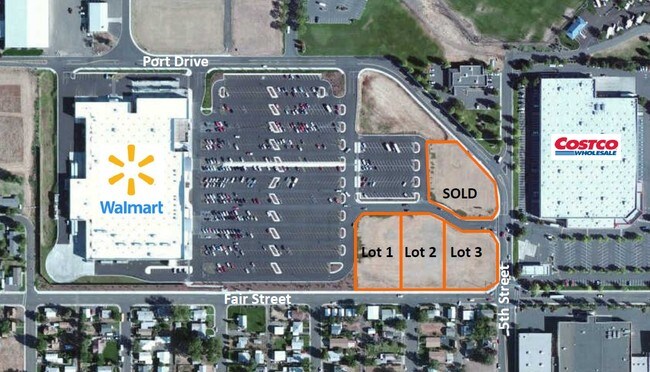
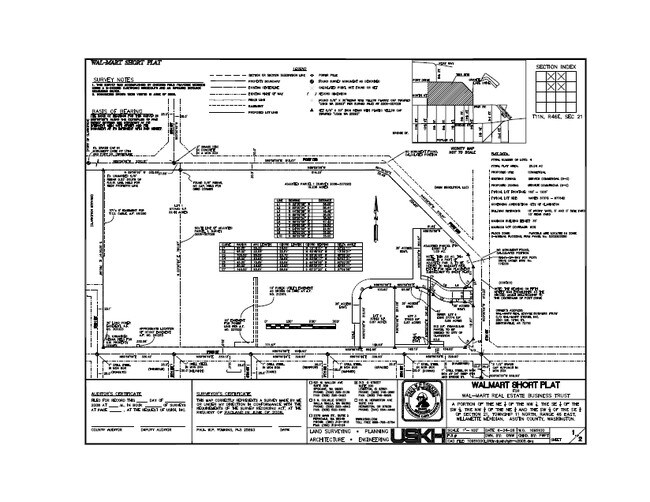
Walmart Short Plat
Lewiston, ID-WA
WALMART SHORT PLAT LOT 4 YB 2014 SQ 4576
6-716-00-004-0000-0000
Asotin
Storebuilding
Washington
2024
4
2025
0.86 AC
960300
Asotin
4,576 SF
DEMOGRAPHICS near 320 5Th St
1 Mile
3 Mile
5 Mile
2024 Total Population
6,369
32,949
48,871
2029 Population
6,577
34,368
51,116
Pop Growth 2024-2029
+ 3.27%
+ 4.31%
+ 4.59%
Average Age
39
41
42
2024 Total Households
2,748
13,668
20,522
HH Growth 2024-2029
+ 3.20%
+ 4.28%
+ 4.62%
Median Household Inc
$46,079
$57,742
$59,765
Avg Household Size
2.20
2.30
2.30
2024 Avg HH Vehicles
2.00
2.00
2.00
Median Home Value
$182,809
$257,795
$266,826
Median Year Built
1951
1967
1971
Nearby Places
Map Layers
Map Styles
 Street
 Aerial
- Restaurants
- Banks
- Shops
- Fitness
- Groceries
PUBLIC TRANSPORTATION
AIRPORT
Lewiston/Nez Perce County
DRIVE
WALK
Distance
Lewiston/Nez Perce County
17 min
6.7 mi
Pullman/Moscow Regional
DRIVE
WALK
Distance
Pullman/Moscow Regional
59 min
39.9 mi
Freight Ports
Port of Tacoma
DRIVE
WALK
Distance
Port of Tacoma
419 min
320.1 mi
Nearby Properties
Address
Land Use
TOTAL SIZE
Lot Size
Zoning
Address
Land Use
TOTAL SIZE
Lot Size
Zoning
0.48 AC
Address
Land Use
TOTAL SIZE
Lot Size
Zoning
18.85 AC
11
Address
Land Use
TOTAL SIZE
Lot Size
Zoning
22.44 AC
1
Address
Land Use
TOTAL SIZE
Lot Size
Zoning
160,676 SF
8.24 AC
1
Address
Land Use
TOTAL SIZE
Lot Size
Zoning
25,810 SF
2.21 AC
Address
Land Use
TOTAL SIZE
Lot Size
Zoning
2.24 AC
Address
Land Use
TOTAL SIZE
Lot Size
Zoning
6.83 AC
Address
Land Use
TOTAL SIZE
Lot Size
Zoning
2.44 AC
Address
Land Use
TOTAL SIZE
Lot Size
Zoning
41,940 SF
1.68 AC
Address
Land Use
TOTAL SIZE
Lot Size
Zoning
52,577 SF
3.76 AC
Address
Land Use
TOTAL SIZE
Lot Size
Zoning
59,815 SF
9.36 AC
1
Address
Land Use
TOTAL SIZE
Lot Size
Zoning
1.60 AC
Address
Land Use
TOTAL SIZE
Lot Size
Zoning
16,126 SF
2.88 AC
Address
Land Use
TOTAL SIZE
Lot Size
Zoning
22,660 SF
7.43 AC
Address
Land Use
TOTAL SIZE
Lot Size
Zoning
22,264 SF
0.50 AC
Address
Land Use
TOTAL SIZE
Lot Size
Zoning
1.35 AC
Address
Land Use
TOTAL SIZE
Lot Size
Zoning
30,002 SF
1.51 AC
Address
Land Use
TOTAL SIZE
Lot Size
Zoning
11,574 SF
1.66 AC
Address
Land Use
TOTAL SIZE
Lot Size
Zoning
42,579 SF
5.74 AC
Address
Land Use
TOTAL SIZE
Lot Size
Zoning
1,647 SF
2.48 AC
Address
Land Use
TOTAL SIZE
Lot Size
Zoning
77,376 SF
2.67 AC
Address
Land Use
TOTAL SIZE
Lot Size
Zoning
1,802 SF
2.18 AC
1
Address
Land Use
TOTAL SIZE
Lot Size
Zoning
29,092 SF
1.56 AC
Address
Land Use
TOTAL SIZE
Lot Size
Zoning
31,620 SF
0.16 AC
NHMU
Address
Land Use
TOTAL SIZE
Lot Size
Zoning
3.94 AC
1
Address
Land Use
TOTAL SIZE
Lot Size
Zoning
38,340 SF
2.67 AC
Address
Land Use
TOTAL SIZE
Lot Size
Zoning
45,476 SF
2.56 AC
Address
Land Use
TOTAL SIZE
Lot Size
Zoning
9,600 SF
0.60 AC
Address
Land Use
TOTAL SIZE
Lot Size
Zoning
Address
Land Use
TOTAL SIZE
Lot Size
Zoning
14,550 SF
1.27 AC
The World's #1 Commercial Real Estate Marketplace
Connect with us
© 2026 CoStar Group
The information above has been obtained from sources believed reliable. While we do not doubt its accuracy we have not verified it and make no guarantee, warranty or representation about it. It is your responsibility to independently confirm its accuracy and completeness. Any projections, opinions, assumptions, or estimates used are for example only and do not represent the current or future performance of the property. The value of this transaction to you depends on tax and other factors which should be evaluated by your tax, financial, and legal advisors. You and your advisors should conduct a careful, independent investigation of the property to determine to your satisfaction the suitability of the property for your needs.