Property Record
320 7Th St, Seal Beach, CA 90740
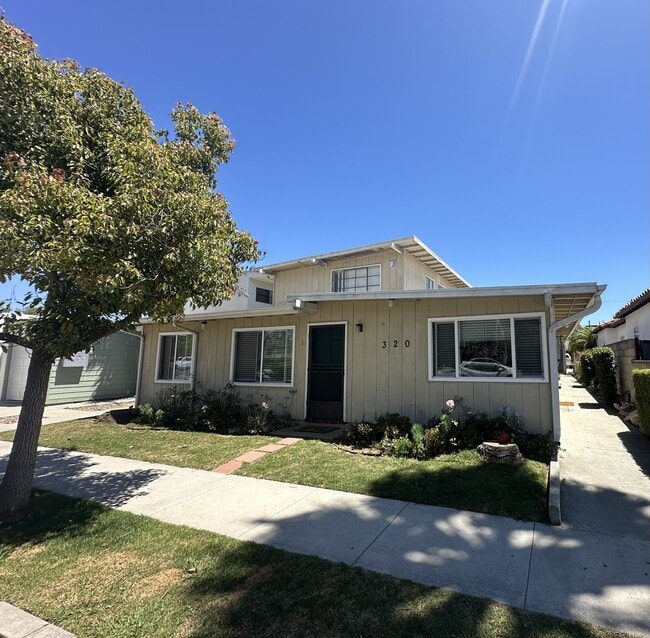

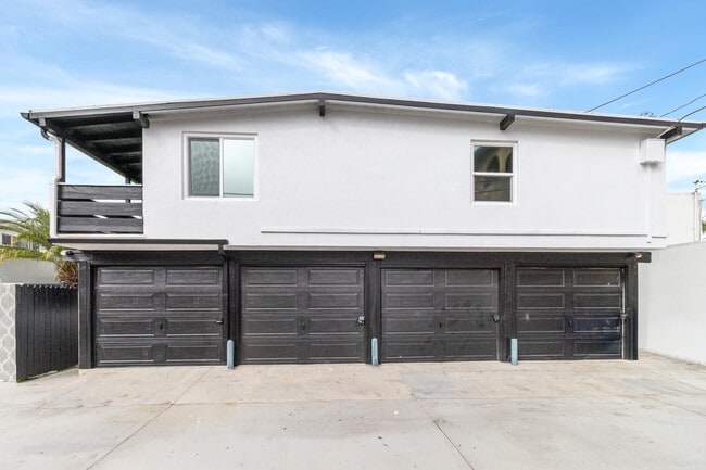
This Property Is For Sale
Property Detail
320 7Th St
Anaheim-Santa Ana-Irvine, CA
A TR STANTON & LOTHIANS 1ST ADD BLK 207 LOT 20 STANTON & LOTHIANS 1ST ADD LOT 20 BLK 207(AND
043-111-24
Orange
Multifamilydwelling
California
R3
20
2024
0.12 AC
2025
Seal Beach
099512
Orange County (California)
5,014 SF
NEARBY LISTINGS FOR SALE OR LEASE
DEMOGRAPHICS near 320 7Th St
1 mile
3 mile
5 mile
2025 Total Population
10,787
68,214
291,700
2030 Population
10,857
68,127
290,187
Pop Growth 2025-2030
+ 0.65%
(0.13%)
(0.52%)
Average Age
46
49
43
2025 Total Households
5,176
33,836
121,727
HH Growth 2025-2030
+ 0.58%
(0.23%)
(0.59%)
Median Household Inc
$124,318
$108,866
$100,094
Avg Household Size
2.00
1.90
2.30
2025 Avg HH Vehicles
2.00
2.00
2.00
Median Home Value
$1,131,091
$1,008,030
$931,419
Median Year Built
1967
1964
1964
Nearby Places
Map Layers
Map Styles
 Street
 Aerial
Transit
 Traffic
 Biking
Places
Listings with unknown addresses are not visible on the map
- Restaurants
- Banks
- Shops
- Fitness
- Groceries
PUBLIC TRANSPORTATION
AIRPORT
Long Beach (Daugherty Field)
Drive
Walk
Distance
Long Beach (Daugherty Field)
15 min
8.0 mi
John Wayne/Orange County
Drive
Walk
Distance
John Wayne/Orange County
23 min
16.5 mi
Los Angeles International
Drive
Walk
Distance
Los Angeles International
38 min
26.9 mi
Nearby Properties
Address
Land Use
TOTAL SIZE
Lot Size
Zoning
Address
Land Use
TOTAL SIZE
Lot Size
Zoning
225,557 SF
10.81 AC
LBPD1
Address
Land Use
TOTAL SIZE
Lot Size
Zoning
454,844 SF
11.37 AC
Address
Land Use
TOTAL SIZE
Lot Size
Zoning
735.20 AC
Address
Land Use
TOTAL SIZE
Lot Size
Zoning
650.36 AC
Address
Land Use
TOTAL SIZE
Lot Size
Zoning
74,318 SF
NEW SHOP C
Address
Land Use
TOTAL SIZE
Lot Size
Zoning
256,538 SF
6.17 AC
NEW SHOPIN
Address
Land Use
TOTAL SIZE
Lot Size
Zoning
11.07 AC
Address
Land Use
TOTAL SIZE
Lot Size
Zoning
392.51 AC
Address
Land Use
TOTAL SIZE
Lot Size
Zoning
3.97 AC
Address
Land Use
TOTAL SIZE
Lot Size
Zoning
16.18 AC
Address
Land Use
TOTAL SIZE
Lot Size
Zoning
54,112 SF
15.43 AC
LBPD1
Address
Land Use
TOTAL SIZE
Lot Size
Zoning
73,076 SF
2.53 AC
LBPD1
Address
Land Use
TOTAL SIZE
Lot Size
Zoning
320.34 AC
Address
Land Use
TOTAL SIZE
Lot Size
Zoning
11.97 AC
Address
Land Use
TOTAL SIZE
Lot Size
Zoning
3.32 AC
Address
Land Use
TOTAL SIZE
Lot Size
Zoning
200,280 SF
13.17 AC
LBPD1
Address
Land Use
TOTAL SIZE
Lot Size
Zoning
58,174 SF
0.80 AC
LBPD2
Address
Land Use
TOTAL SIZE
Lot Size
Zoning
11.93 AC
Address
Land Use
TOTAL SIZE
Lot Size
Zoning
60,652 SF
0.91 AC
LBR1N
Address
Land Use
TOTAL SIZE
Lot Size
Zoning
9.24 AC
Address
Land Use
TOTAL SIZE
Lot Size
Zoning
3.17 AC
Address
Land Use
TOTAL SIZE
Lot Size
Zoning
Address
Land Use
TOTAL SIZE
Lot Size
Zoning
168.42 AC
Address
Land Use
TOTAL SIZE
Lot Size
Zoning
Address
Land Use
TOTAL SIZE
Lot Size
Zoning
5.50 AC
Address
Land Use
TOTAL SIZE
Lot Size
Zoning
3.22 AC
Address
Land Use
TOTAL SIZE
Lot Size
Zoning
Address
Land Use
TOTAL SIZE
Lot Size
Zoning
71,949 SF
5.65 AC
Address
Land Use
TOTAL SIZE
Lot Size
Zoning
5.41 AC
Address
Land Use
TOTAL SIZE
Lot Size
Zoning
The World's #1 Commercial Real Estate Marketplace
Connect with us
© 2026 CoStar Group
The information above has been obtained from sources believed reliable. While we do not doubt its accuracy we have not verified it and make no guarantee, warranty or representation about it. It is your responsibility to independently confirm its accuracy and completeness. Any projections, opinions, assumptions, or estimates used are for example only and do not represent the current or future performance of the property. The value of this transaction to you depends on tax and other factors which should be evaluated by your tax, financial, and legal advisors. You and your advisors should conduct a careful, independent investigation of the property to determine to your satisfaction the suitability of the property for your needs.