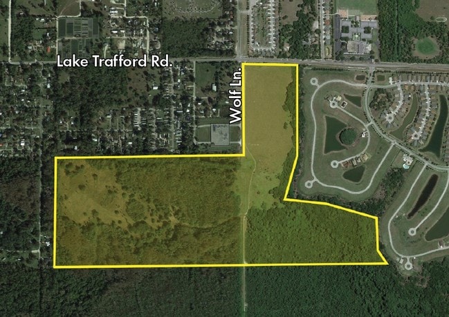
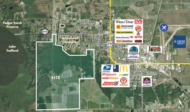
Property Record
320 Acres, Naples, FL 34142
Save to a Folder
{{folder.Name}}
{{folder.ListingIds.length}} Properties
{{folder.ListingIds.length}} Property
Create a New Folder
Property Detail
320 Acres
00114160001
7 47 29 ALL
Agriculturalland
COLLIER
A-MHO
Florida
AE The base floodplain where base flood elevations are provided. AE Zones are now used on new format FIRMs instead of A1-A30 Zones.
320 AC
2024
Outlying Collier County
2025
Southwest Florida
011204
Naples-Marco Island, FL
NEARBY LISTINGS FOR SALE OR LEASE
-
-
View all Naples listings for sale on LoopNet.com
DEMOGRAPHICS near 320 Acres
1 mile
3 mile
5 mile
2025 Total Population
4,548
17,188
20,341
2030 Population
4,792
17,799
21,006
Pop Growth 2025-2030
+ 5.36%
+ 3.55%
+ 3.27%
Average Age
31
32
32
2025 Total Households
1,164
4,318
5,220
HH Growth 2025-2030
+ 4.98%
+ 2.52%
+ 2.18%
Median Household Inc
$63,900
$51,075
$48,202
Avg Household Size
3.80
3.60
3.50
2025 Avg HH Vehicles
2.00
2.00
2.00
Median Home Value
$301,587
$239,104
$243,455
Median Year Built
2001
1992
1991
Nearby Places
Map Layers
Map Styles
 Street
 Aerial
Layers
 Traffic
 Biking
Places
Listings with unknown addresses are not visible on the map
- Restaurants
- Banks
- Shops
- Fitness
- Groceries
PUBLIC TRANSPORTATION
AIRPORT
Southwest Florida International
Drive
Walk
Distance
Southwest Florida International
49 min
30.7 mi
Freight Ports
Port Everglades
Drive
Walk
Distance
Port Everglades
126 min
103.1 mi
SALE & LEASE HISTORY
LISTING DATE
SALE/LEASE

Nov 06, 2019
For Sale
Jun 13, 2023
For Sale
Nearby Properties
Address
Land Use
TOTAL SIZE
Lot Size
Zoning
Address
Land Use
TOTAL SIZE
Lot Size
Zoning
118,281 SF
24.62 AC
A
Address
Land Use
TOTAL SIZE
Lot Size
Zoning
182,696 SF
12.78 AC
MPUD
Address
Land Use
TOTAL SIZE
Lot Size
Zoning
90,082 SF
9.37 AC
MPUD
Address
Land Use
TOTAL SIZE
Lot Size
Zoning
25,308 SF
5.96 AC
PUD
Address
Land Use
TOTAL SIZE
Lot Size
Zoning
33,530 SF
3.83 AC
PUD
Address
Land Use
TOTAL SIZE
Lot Size
Zoning
45,799 SF
8.70 AC
RMF-6
Address
Land Use
TOTAL SIZE
Lot Size
Zoning
4,719 SF
2.95 AC
C-4-MSOSD
Address
Land Use
TOTAL SIZE
Lot Size
Zoning
78,445 SF
6.40 AC
RMF-16
Address
Land Use
TOTAL SIZE
Lot Size
Zoning
93,715 SF
8.97 AC
PUD
Address
Land Use
TOTAL SIZE
Lot Size
Zoning
22,386 SF
5.66 AC
Address
Land Use
TOTAL SIZE
Lot Size
Zoning
40,653 SF
5 AC
PUD
Address
Land Use
TOTAL SIZE
Lot Size
Zoning
638 AC
A-MHO
Address
Land Use
TOTAL SIZE
Lot Size
Zoning
15,048 SF
2.32 AC
C4
Address
Land Use
TOTAL SIZE
Lot Size
Zoning
43,407 SF
15 AC
A
Address
Land Use
TOTAL SIZE
Lot Size
Zoning
88,135 SF
17.56 AC
C3
Address
Land Use
TOTAL SIZE
Lot Size
Zoning
27,696 SF
4.59 AC
RPUD
Address
Land Use
TOTAL SIZE
Lot Size
Zoning
2,337 SF
342.04 AC
A
Address
Land Use
TOTAL SIZE
Lot Size
Zoning
19,670 SF
4.77 AC
RMF-6
Address
Land Use
TOTAL SIZE
Lot Size
Zoning
11,668 SF
1.38 AC
Address
Land Use
TOTAL SIZE
Lot Size
Zoning
27,906 SF
2.79 AC
PUD
Address
Land Use
TOTAL SIZE
Lot Size
Zoning
43,077 SF
4.40 AC
VR
Address
Land Use
TOTAL SIZE
Lot Size
Zoning
13,974 SF
9.27 AC
RSF4
Address
Land Use
TOTAL SIZE
Lot Size
Zoning
22,867 SF
18.18 AC
RMF6
Address
Land Use
TOTAL SIZE
Lot Size
Zoning
19,834 SF
1.21 AC
MH
Address
Land Use
TOTAL SIZE
Lot Size
Zoning
40,552 SF
3.21 AC
VR
Address
Land Use
TOTAL SIZE
Lot Size
Zoning
12,864 SF
2.34 AC
RPUD
Address
Land Use
TOTAL SIZE
Lot Size
Zoning
7,114 SF
1.45 AC
Address
Land Use
TOTAL SIZE
Lot Size
Zoning
5,290 SF
0.64 AC
C-4-SR29CO
Address
Land Use
TOTAL SIZE
Lot Size
Zoning
9,170 SF
0.96 AC
C4
The World's #1 Commercial Real Estate Marketplace
Connect with us
© 2026 CoStar Group
The information above has been obtained from sources believed reliable. While we do not doubt its accuracy we have not verified it and make no guarantee, warranty or representation about it. It is your responsibility to independently confirm its accuracy and completeness. Any projections, opinions, assumptions, or estimates used are for example only and do not represent the current or future performance of the property. The value of this transaction to you depends on tax and other factors which should be evaluated by your tax, financial, and legal advisors. You and your advisors should conduct a careful, independent investigation of the property to determine to your satisfaction the suitability of the property for your needs.