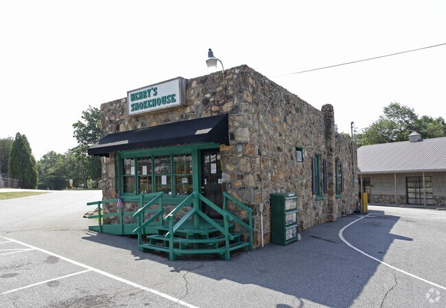
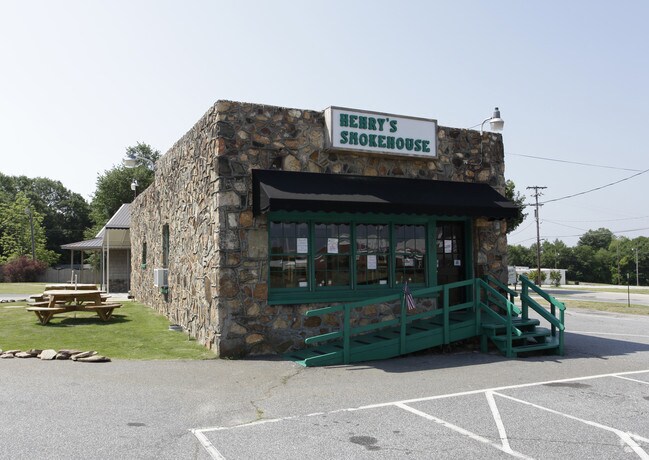
Property Record
320 Hillcrest Dr, Greer, SC 29651
NEARBY LISTINGS FOR SALE OR LEASE
Property Detail
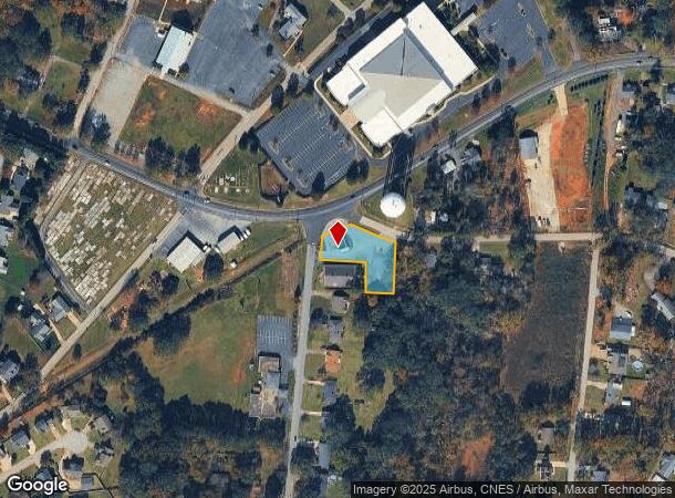
320 Hillcrest Dr
Greenville-Anderson-Mauldin, SC
Hillcrest Heights
T016.00-02-034.03
MAP T016.00; 3
Restaurantbuilding
Greenville
X
South Carolina
45045C0334F
034.03
2025
0.59 AC
2024
Wade Hampton
002506
Greenville/Spartanburg
968 SF
DEMOGRAPHICS near 320 Hillcrest Dr
1 Mile
3 Mile
5 Mile
2024 Total Population
3,573
41,363
106,233
2029 Population
3,945
45,651
117,354
Pop Growth 2024-2029
+ 10.41%
+ 10.37%
+ 10.47%
Average Age
41
40
40
2024 Total Households
1,459
16,671
41,737
HH Growth 2024-2029
+ 10.56%
+ 10.47%
+ 10.55%
Median Household Inc
$60,732
$62,542
$69,419
Avg Household Size
2.40
2.40
2.50
2024 Avg HH Vehicles
2.00
2.00
2.00
Median Home Value
$230,060
$224,410
$239,180
Median Year Built
1991
1993
1991
Nearby Places
Map Layers
Map Styles
 Street
 Aerial
- Restaurants
- Banks
- Shops
- Fitness
- Groceries
PUBLIC TRANSPORTATION
AIRPORT
Greenville Spartanburg International
DRIVE
WALK
Distance
Greenville Spartanburg International
18 min
7.5 mi
Freight Ports
North Charleston Terminal
DRIVE
WALK
Distance
North Charleston Terminal
241 min
209.3 mi
Nearby Properties
Address
Land Use
TOTAL SIZE
Lot Size
Zoning
Address
Land Use
TOTAL SIZE
Lot Size
Zoning
5.07 AC
C2
Address
Land Use
TOTAL SIZE
Lot Size
Zoning
14.20 AC
UNZONED
Address
Land Use
TOTAL SIZE
Lot Size
Zoning
13.25 AC
I1
Address
Land Use
TOTAL SIZE
Lot Size
Zoning
11.80 AC
R10
Address
Land Use
TOTAL SIZE
Lot Size
Zoning
11.30 AC
R10
Address
Land Use
TOTAL SIZE
Lot Size
Zoning
0.42 AC
OD
Address
Land Use
TOTAL SIZE
Lot Size
Zoning
8.22 AC
I1
Address
Land Use
TOTAL SIZE
Lot Size
Zoning
1.05 AC
S1
Address
Land Use
TOTAL SIZE
Lot Size
Zoning
1.90 AC
I1
Address
Land Use
TOTAL SIZE
Lot Size
Zoning
25.70 AC
R20
Address
Land Use
TOTAL SIZE
Lot Size
Zoning
6.81 AC
RM
Address
Land Use
TOTAL SIZE
Lot Size
Zoning
91,927 SF
21.14 AC
Address
Land Use
TOTAL SIZE
Lot Size
Zoning
10.20 AC
S1
Address
Land Use
TOTAL SIZE
Lot Size
Zoning
41.90 AC
RMA
Address
Land Use
TOTAL SIZE
Lot Size
Zoning
5.23 AC
I1
Address
Land Use
TOTAL SIZE
Lot Size
Zoning
5.73 AC
C1
Address
Land Use
TOTAL SIZE
Lot Size
Zoning
14.33 AC
I1
Address
Land Use
TOTAL SIZE
Lot Size
Zoning
22.35 AC
R20
Address
Land Use
TOTAL SIZE
Lot Size
Zoning
532 SF
72.61 AC
I1
Address
Land Use
TOTAL SIZE
Lot Size
Zoning
4.07 AC
OD
Address
Land Use
TOTAL SIZE
Lot Size
Zoning
6.90 AC
I1
Address
Land Use
TOTAL SIZE
Lot Size
Zoning
19.02 AC
RRROW
Address
Land Use
TOTAL SIZE
Lot Size
Zoning
11.70 AC
C2
Address
Land Use
TOTAL SIZE
Lot Size
Zoning
7.12 AC
R15
Address
Land Use
TOTAL SIZE
Lot Size
Zoning
5.47 AC
RM1
Address
Land Use
TOTAL SIZE
Lot Size
Zoning
5.15 AC
R15
Address
Land Use
TOTAL SIZE
Lot Size
Zoning
1.40 AC
C2
Address
Land Use
TOTAL SIZE
Lot Size
Zoning
3.56 AC
OD
Address
Land Use
TOTAL SIZE
Lot Size
Zoning
5 AC
C3
Address
Land Use
TOTAL SIZE
Lot Size
Zoning
6.62 AC
I1
The World's #1 Commercial Real Estate Marketplace
Connect with us
© 2025 CoStar Group
The information above has been obtained from sources believed reliable. While we do not doubt its accuracy we have not verified it and make no guarantee, warranty or representation about it. It is your responsibility to independently confirm its accuracy and completeness. Any projections, opinions, assumptions, or estimates used are for example only and do not represent the current or future performance of the property. The value of this transaction to you depends on tax and other factors which should be evaluated by your tax, financial, and legal advisors. You and your advisors should conduct a careful, independent investigation of the property to determine to your satisfaction the suitability of the property for your needs.