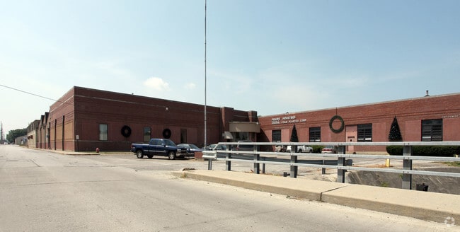
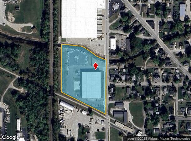
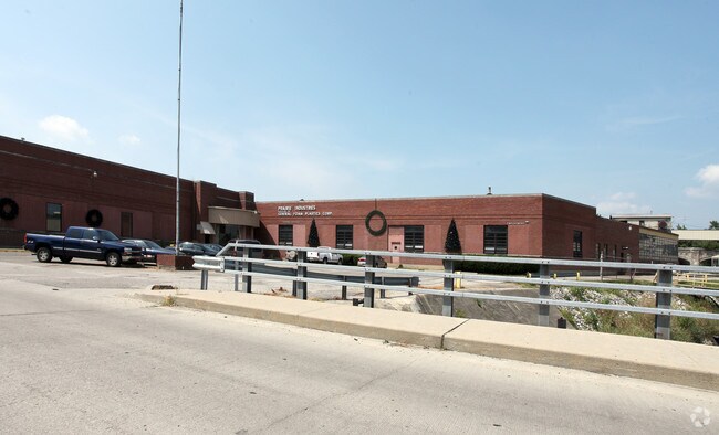
Property Record
320 N Patterson St, Lebanon, IN 46052
NEARBY LISTINGS FOR SALE OR LEASE
Property Detail
320 N Patterson St
06-10-36-000-221.000-002
Partner Pl
Warehouse
PT OL 60 & VACATED INDUSTRIAL STREET
AE
Boone
18011C0186E
Indiana
2024
5.04 AC
2025
Far Boone County
810400
Indianapolis
45,000 SF
Indianapolis-Carmel-Anderson, IN
DEMOGRAPHICS near 320 N Patterson St
1 Mile
3 Mile
5 Mile
2024 Total Population
9,476
18,479
20,200
2029 Population
10,641
20,634
22,542
Pop Growth 2024-2029
+ 12.29%
+ 11.66%
+ 11.59%
Average Age
39
41
41
2024 Total Households
3,997
7,867
8,479
HH Growth 2024-2029
+ 12.66%
+ 11.97%
+ 11.91%
Median Household Inc
$57,341
$67,274
$68,406
Avg Household Size
2.30
2.30
2.30
2024 Avg HH Vehicles
2.00
2.00
2.00
Median Home Value
$144,705
$177,024
$183,587
Median Year Built
1969
1976
1976
Nearby Places
- Restaurants
- Banks
- Shops
- Fitness
- Groceries
PUBLIC TRANSPORTATION
AIRPORT
Indianapolis International
DRIVE
WALK
Distance
Indianapolis International
50 min
33.3 mi
Freight Ports
Port of Toledo
DRIVE
WALK
Distance
Port of Toledo
287 min
241.8 mi
Nearby Properties
Address
Land Use
TOTAL SIZE
Lot Size
Zoning
Address
Land Use
TOTAL SIZE
Lot Size
Zoning
518,530 SF
48.65 AC
ZO01
Address
Land Use
TOTAL SIZE
Lot Size
Zoning
418,084 SF
40.25 AC
ZO01
Address
Land Use
TOTAL SIZE
Lot Size
Zoning
1,029,528 SF
58.50 AC
ZO01
Address
Land Use
TOTAL SIZE
Lot Size
Zoning
589,616 SF
49.19 AC
ZO01
Address
Land Use
TOTAL SIZE
Lot Size
Zoning
962,135 SF
56.15 AC
ZO01
Address
Land Use
TOTAL SIZE
Lot Size
Zoning
215,406 SF
33 AC
ZO01
Address
Land Use
TOTAL SIZE
Lot Size
Zoning
559,722 SF
41.90 AC
ZO01
Address
Land Use
TOTAL SIZE
Lot Size
Zoning
842,006 SF
57.92 AC
ZO01
Address
Land Use
TOTAL SIZE
Lot Size
Zoning
741,000 SF
67.48 AC
ZO01
Address
Land Use
TOTAL SIZE
Lot Size
Zoning
6,917 SF
26.16 AC
ZO01
Address
Land Use
TOTAL SIZE
Lot Size
Zoning
392,368 SF
54.57 AC
ZO01
Address
Land Use
TOTAL SIZE
Lot Size
Zoning
695,269 SF
44.28 AC
ZO01
Address
Land Use
TOTAL SIZE
Lot Size
Zoning
707,952 SF
32.35 AC
ZO01
Address
Land Use
TOTAL SIZE
Lot Size
Zoning
615,708 SF
41.91 AC
ZO01
Address
Land Use
TOTAL SIZE
Lot Size
Zoning
478,230 SF
28.96 AC
ZO01
Address
Land Use
TOTAL SIZE
Lot Size
Zoning
13.53 AC
ZO01
Address
Land Use
TOTAL SIZE
Lot Size
Zoning
149,353 SF
29.98 AC
ZO01
Address
Land Use
TOTAL SIZE
Lot Size
Zoning
479,040 SF
44.07 AC
ZO01
Address
Land Use
TOTAL SIZE
Lot Size
Zoning
204,480 SF
27.67 AC
ZO01
Address
Land Use
TOTAL SIZE
Lot Size
Zoning
396,096 SF
23.32 AC
ZO01
Address
Land Use
TOTAL SIZE
Lot Size
Zoning
395,686 SF
34.20 AC
ZO01
Address
Land Use
TOTAL SIZE
Lot Size
Zoning
234,678 SF
0.84 AC
R6
Address
Land Use
TOTAL SIZE
Lot Size
Zoning
171,748 SF
10.33 AC
ZO01
Address
Land Use
TOTAL SIZE
Lot Size
Zoning
6,278 SF
11.88 AC
ZO01
Address
Land Use
TOTAL SIZE
Lot Size
Zoning
250,000 SF
21.40 AC
ZO01
Address
Land Use
TOTAL SIZE
Lot Size
Zoning
219,220 SF
12.86 AC
ZO01
Address
Land Use
TOTAL SIZE
Lot Size
Zoning
4,379 SF
19.22 AC
ZO01
Address
Land Use
TOTAL SIZE
Lot Size
Zoning
225,000 SF
22.68 AC
ZO01
Address
Land Use
TOTAL SIZE
Lot Size
Zoning
106,152 SF
7.47 AC
ZO01
Address
Land Use
TOTAL SIZE
Lot Size
Zoning
193,382 SF
30.23 AC
ZO01
The World's #1 Commercial Real Estate Marketplace
Connect with us
© 2025 CoStar Group
The information above has been obtained from sources believed reliable. While we do not doubt its accuracy we have not verified it and make no guarantee, warranty or representation about it. It is your responsibility to independently confirm its accuracy and completeness. Any projections, opinions, assumptions, or estimates used are for example only and do not represent the current or future performance of the property. The value of this transaction to you depends on tax and other factors which should be evaluated by your tax, financial, and legal advisors. You and your advisors should conduct a careful, independent investigation of the property to determine to your satisfaction the suitability of the property for your needs.