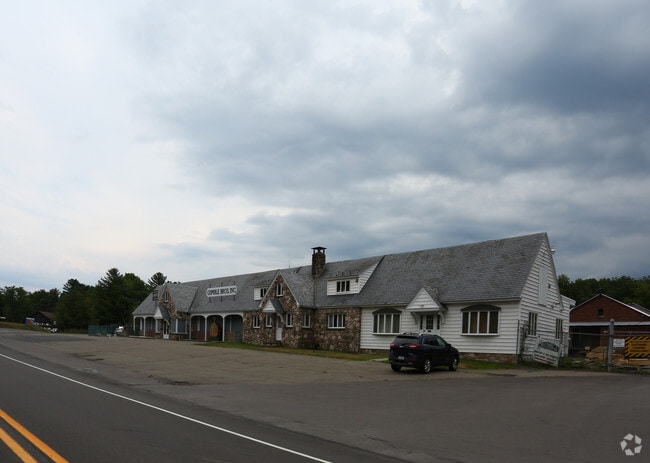
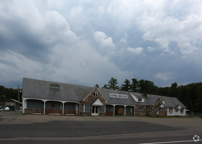
Property Record
320 Route 507, Tafton, PA 18464
NEARBY LISTINGS FOR SALE OR LEASE
-
-
View all Tafton listings for sale on LoopNet.com
Property Detail
320 Route 507
009617
St Rt 507
Commercialnec
47.25 AC STORE WAREHOUSE 7 OBS
X
Pike
42127C0412D
Pennsylvania
2024
47.25 AC
2025
Pike County
950303
Northern New Jersey
23,758 SF
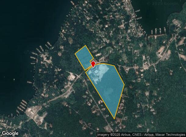
Hemlock Farms, PA
DEMOGRAPHICS near 320 Route 507
1 mile
3 mile
5 mile
2024 Total Population
647
3,790
10,839
2029 Population
730
4,099
11,657
Pop Growth 2024-2029
+ 12.83%
+ 8.15%
+ 7.55%
Average Age
52
50
48
2024 Total Households
306
1,701
4,812
HH Growth 2024-2029
+ 12.75%
+ 8.17%
+ 7.40%
Median Household Inc
$73,557
$57,127
$59,640
Avg Household Size
2.10
2.20
2.20
2024 Avg HH Vehicles
2.00
2.00
2.00
Median Home Value
$284,677
$266,887
$246,254
Median Year Built
1981
1981
1981
Nearby Places
Map Layers
Map Styles
 Street
 Aerial
Transit
 Traffic
 Biking
Places
Listings with unknown addresses are not visible on the map
- Restaurants
- Banks
- Shops
- Fitness
- Groceries
PUBLIC TRANSPORTATION
AIRPORT
Wilkes-Barre/Scranton International
Drive
Walk
Distance
Wilkes-Barre/Scranton International
57 min
42.5 mi
Nearby Properties
Address
Land Use
TOTAL SIZE
Lot Size
Zoning
Address
Land Use
TOTAL SIZE
Lot Size
Zoning
13.88 AC
C1
Address
Land Use
TOTAL SIZE
Lot Size
Zoning
5,621 SF
7.63 AC
RR
Address
Land Use
TOTAL SIZE
Lot Size
Zoning
5,757 SF
0.62 AC
RR
Address
Land Use
TOTAL SIZE
Lot Size
Zoning
9,740 SF
1.04 AC
RR
Address
Land Use
TOTAL SIZE
Lot Size
Zoning
8,085 SF
0.53 AC
RR
Address
Land Use
TOTAL SIZE
Lot Size
Zoning
0.79 AC
Address
Land Use
TOTAL SIZE
Lot Size
Zoning
5,048 SF
1.15 AC
RR
Address
Land Use
TOTAL SIZE
Lot Size
Zoning
55.33 AC
C2
Address
Land Use
TOTAL SIZE
Lot Size
Zoning
5,678 SF
0.96 AC
RR
Address
Land Use
TOTAL SIZE
Lot Size
Zoning
11.53 AC
C1
Address
Land Use
TOTAL SIZE
Lot Size
Zoning
6,510 SF
0.48 AC
RR
Address
Land Use
TOTAL SIZE
Lot Size
Zoning
235,718 SF
30.55 AC
Address
Land Use
TOTAL SIZE
Lot Size
Zoning
4,525 SF
0.69 AC
RR
Address
Land Use
TOTAL SIZE
Lot Size
Zoning
4,566 SF
0.32 AC
RR
Address
Land Use
TOTAL SIZE
Lot Size
Zoning
5,124 SF
0.46 AC
RR
Address
Land Use
TOTAL SIZE
Lot Size
Zoning
6,541 SF
0.48 AC
RR
Address
Land Use
TOTAL SIZE
Lot Size
Zoning
4,426 SF
0.25 AC
RR
Address
Land Use
TOTAL SIZE
Lot Size
Zoning
6,472 SF
0.44 AC
RR
Address
Land Use
TOTAL SIZE
Lot Size
Zoning
4,882 SF
1.14 AC
RR
Address
Land Use
TOTAL SIZE
Lot Size
Zoning
3,028 SF
1 AC
RR
Address
Land Use
TOTAL SIZE
Lot Size
Zoning
3,409 SF
2.19 AC
RR
Address
Land Use
TOTAL SIZE
Lot Size
Zoning
7,840 SF
3,084.93 AC
Address
Land Use
TOTAL SIZE
Lot Size
Zoning
4,144 SF
1.03 AC
RR
Address
Land Use
TOTAL SIZE
Lot Size
Zoning
5,072 SF
0.17 AC
RR
Address
Land Use
TOTAL SIZE
Lot Size
Zoning
3,702 SF
0.28 AC
RR
Address
Land Use
TOTAL SIZE
Lot Size
Zoning
3,992 SF
0.18 AC
RR
Address
Land Use
TOTAL SIZE
Lot Size
Zoning
3,130 SF
1 AC
RR
Address
Land Use
TOTAL SIZE
Lot Size
Zoning
2,228 SF
0.46 AC
RR
Address
Land Use
TOTAL SIZE
Lot Size
Zoning
3,545 SF
0.53 AC
RR
The World's #1 Commercial Real Estate Marketplace
Connect with us
© 2026 CoStar Group
The information above has been obtained from sources believed reliable. While we do not doubt its accuracy we have not verified it and make no guarantee, warranty or representation about it. It is your responsibility to independently confirm its accuracy and completeness. Any projections, opinions, assumptions, or estimates used are for example only and do not represent the current or future performance of the property. The value of this transaction to you depends on tax and other factors which should be evaluated by your tax, financial, and legal advisors. You and your advisors should conduct a careful, independent investigation of the property to determine to your satisfaction the suitability of the property for your needs.