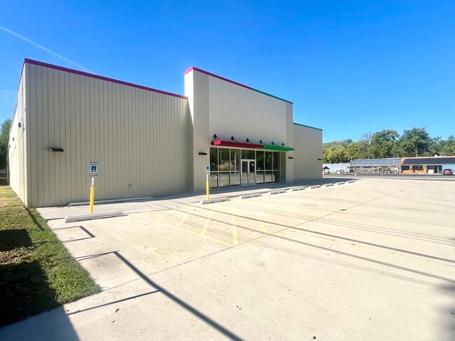
Property Record
320 S Adams St, Manito, IL 61546

Current Lease Availabilities
NEARBY LISTINGS FOR SALE OR LEASE
-
-
View all Manito listings for lease on LoopNet.com
Property Detail
320 S Adams St
Other Market Areas
Original Town Now Village Of Manito
03-21-310-005
ORIG TOWN LOTS 7 & 10 BLK 36 191
Commercialnec
Mason
X
Illinois
17179C0300E
7,10
0
0.48 AC
2024
Illinois North Area
956300
DEMOGRAPHICS near 320 S Adams St
1 mile
3 mile
5 mile
2024 Total Population
1,585
2,047
3,186
2029 Population
1,540
1,994
3,117
Pop Growth 2024-2029
(2.84%)
(2.59%)
(2.17%)
Average Age
42
42
43
2024 Total Households
652
843
1,317
HH Growth 2024-2029
(2.91%)
(2.61%)
(2.20%)
Median Household Inc
$62,459
$62,107
$61,642
Avg Household Size
2.40
2.40
2.40
2024 Avg HH Vehicles
2.00
2.00
2.00
Median Home Value
$97,188
$102,527
$110,957
Median Year Built
1967
1969
1970
Nearby Places
Map Layers
Map Styles
 Street
 Aerial
Transit
 Traffic
 Biking
Places
Listings with unknown addresses are not visible on the map
- Restaurants
- Banks
- Shops
- Fitness
- Groceries
PUBLIC TRANSPORTATION
AIRPORT
General Downing - Peoria International
Drive
Walk
Distance
General Downing - Peoria International
46 min
28.0 mi
Nearby Properties
Address
Land Use
TOTAL SIZE
Lot Size
Zoning
Address
Land Use
TOTAL SIZE
Lot Size
Zoning
5.99 AC
Address
Land Use
TOTAL SIZE
Lot Size
Zoning
5,204 SF
215 AC
Address
Land Use
TOTAL SIZE
Lot Size
Zoning
8,633 SF
15 AC
Address
Land Use
TOTAL SIZE
Lot Size
Zoning
0.71 AC
CITY
Address
Land Use
TOTAL SIZE
Lot Size
Zoning
9,408 SF
119.88 AC
Address
Land Use
TOTAL SIZE
Lot Size
Zoning
4,073 SF
6.36 AC
Address
Land Use
TOTAL SIZE
Lot Size
Zoning
3.66 AC
CITY
Address
Land Use
TOTAL SIZE
Lot Size
Zoning
4,374 SF
110 AC
Address
Land Use
TOTAL SIZE
Lot Size
Zoning
5.51 AC
CITY
Address
Land Use
TOTAL SIZE
Lot Size
Zoning
4,918 SF
15.72 AC
Address
Land Use
TOTAL SIZE
Lot Size
Zoning
162.78 AC
A
Address
Land Use
TOTAL SIZE
Lot Size
Zoning
0.71 AC
CITY
Address
Land Use
TOTAL SIZE
Lot Size
Zoning
237.26 AC
Address
Land Use
TOTAL SIZE
Lot Size
Zoning
11.38 AC
A
Address
Land Use
TOTAL SIZE
Lot Size
Zoning
Address
Land Use
TOTAL SIZE
Lot Size
Zoning
159.41 AC
A
Address
Land Use
TOTAL SIZE
Lot Size
Zoning
1.40 AC
CITY
Address
Land Use
TOTAL SIZE
Lot Size
Zoning
2,240 SF
157 AC
Address
Land Use
TOTAL SIZE
Lot Size
Zoning
1.48 AC
CITY
Address
Land Use
TOTAL SIZE
Lot Size
Zoning
Address
Land Use
TOTAL SIZE
Lot Size
Zoning
1.59 AC
CITY
Address
Land Use
TOTAL SIZE
Lot Size
Zoning
5,441 SF
20 AC
Address
Land Use
TOTAL SIZE
Lot Size
Zoning
3,986 SF
40 AC
Address
Land Use
TOTAL SIZE
Lot Size
Zoning
7,458 SF
2.83 AC
Address
Land Use
TOTAL SIZE
Lot Size
Zoning
896 SF
147.45 AC
Address
Land Use
TOTAL SIZE
Lot Size
Zoning
0.93 AC
CITY
Address
Land Use
TOTAL SIZE
Lot Size
Zoning
7,056 SF
2.31 AC
Address
Land Use
TOTAL SIZE
Lot Size
Zoning
212.90 AC
The World's #1 Commercial Real Estate Marketplace
Connect with us
© 2026 CoStar Group
The information above has been obtained from sources believed reliable. While we do not doubt its accuracy we have not verified it and make no guarantee, warranty or representation about it. It is your responsibility to independently confirm its accuracy and completeness. Any projections, opinions, assumptions, or estimates used are for example only and do not represent the current or future performance of the property. The value of this transaction to you depends on tax and other factors which should be evaluated by your tax, financial, and legal advisors. You and your advisors should conduct a careful, independent investigation of the property to determine to your satisfaction the suitability of the property for your needs.