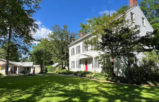
Property Record
320 Sawkill Rd, Kingston, NY 12401


Save to a Folder
{{folder.Name}}
{{folder.ListingIds.length}} Properties
{{folder.ListingIds.length}} Property
Create a New Folder
Property Detail
320 Sawkill Rd
5400-048.010-0001-016.100-0000
ULSTER
Commercialbuilding
New York
37
16.100
C and X Area of minimal flood hazard, usually depicted on FIRMs as above the 500-year flood level.
8.30 AC
2025
Newburgh/Kingston
2025
Other Market Areas
951500
Kingston, NY
2,432 SF
NEARBY LISTINGS FOR SALE OR LEASE
DEMOGRAPHICS near 320 Sawkill Rd
1 mile
3 mile
5 mile
2025 Total Population
1,386
30,004
45,384
2030 Population
1,402
29,645
44,749
Pop Growth 2025-2030
+ 1.15%
(1.20%)
(1.40%)
Average Age
46
43
44
2025 Total Households
645
12,719
19,225
HH Growth 2025-2030
+ 1.55%
(1.23%)
(1.45%)
Median Household Inc
$76,099
$75,676
$79,087
Avg Household Size
2.00
2.20
2.20
2025 Avg HH Vehicles
2.00
2.00
2.00
Median Home Value
$299,999
$311,552
$326,276
Median Year Built
1967
1954
1957
Nearby Places
Map Layers
Map Styles
 Street
 Aerial
Layers
 Traffic
 Biking
Places
Listings with unknown addresses are not visible on the map
- Restaurants
- Banks
- Shops
- Fitness
- Groceries
PUBLIC TRANSPORTATION
AIRPORT
New York Stewart International
Drive
Walk
Distance
New York Stewart International
53 min
39.4 mi
Freight Ports
Albany, NY Port
Drive
Walk
Distance
Albany, NY Port
66 min
52.8 mi
SALE & LEASE HISTORY
LISTING DATE
SALE/LEASE

Jul 12, 2024
For Sale
Nearby Properties
Address
Land Use
TOTAL SIZE
Lot Size
Zoning
Address
Land Use
TOTAL SIZE
Lot Size
Zoning
21.40 AC
R-1
Address
Land Use
TOTAL SIZE
Lot Size
Zoning
80,640 SF
6.10 AC
37
Address
Land Use
TOTAL SIZE
Lot Size
Zoning
198,029 SF
14.10 AC
37
Address
Land Use
TOTAL SIZE
Lot Size
Zoning
181,151 SF
4.90 AC
SD
Address
Land Use
TOTAL SIZE
Lot Size
Zoning
425,087 SF
16.10 AC
36
Address
Land Use
TOTAL SIZE
Lot Size
Zoning
250,613 SF
11.70 AC
SD
Address
Land Use
TOTAL SIZE
Lot Size
Zoning
135,158 SF
31.80 AC
R-1
Address
Land Use
TOTAL SIZE
Lot Size
Zoning
142,823 SF
47.67 AC
33
Address
Land Use
TOTAL SIZE
Lot Size
Zoning
10,521 SF
12.10 AC
SD
Address
Land Use
TOTAL SIZE
Lot Size
Zoning
24,321 SF
46.40 AC
T2C
Address
Land Use
TOTAL SIZE
Lot Size
Zoning
109,860 SF
8.60 AC
35
Address
Land Use
TOTAL SIZE
Lot Size
Zoning
76,788 SF
0.77 AC
T5N
Address
Land Use
TOTAL SIZE
Lot Size
Zoning
Address
Land Use
TOTAL SIZE
Lot Size
Zoning
143,271 SF
20.40 AC
SD
Address
Land Use
TOTAL SIZE
Lot Size
Zoning
16,933 SF
14.90 AC
SD
Address
Land Use
TOTAL SIZE
Lot Size
Zoning
67,180 SF
2.60 AC
T5MS
Address
Land Use
TOTAL SIZE
Lot Size
Zoning
205,740 SF
15 AC
36
Address
Land Use
TOTAL SIZE
Lot Size
Zoning
152,723 SF
9.60 AC
SD
Address
Land Use
TOTAL SIZE
Lot Size
Zoning
97,636 SF
2.60 AC
T5MS
Address
Land Use
TOTAL SIZE
Lot Size
Zoning
23.30 AC
37
Address
Land Use
TOTAL SIZE
Lot Size
Zoning
116,744 SF
12.40 AC
33
Address
Land Use
TOTAL SIZE
Lot Size
Zoning
8,674 SF
10.90 AC
SD
Address
Land Use
TOTAL SIZE
Lot Size
Zoning
67,566 SF
2.90 AC
T5N
Address
Land Use
TOTAL SIZE
Lot Size
Zoning
76,577 SF
1.30 AC
T5F
Address
Land Use
TOTAL SIZE
Lot Size
Zoning
10,124 SF
7.50 AC
SD
Address
Land Use
TOTAL SIZE
Lot Size
Zoning
12.70 AC
36
Address
Land Use
TOTAL SIZE
Lot Size
Zoning
2,670 SF
20.90 AC
SD
Address
Land Use
TOTAL SIZE
Lot Size
Zoning
11,488 SF
10.80 AC
SD
Address
Land Use
TOTAL SIZE
Lot Size
Zoning
129,612 SF
11.30 AC
36
Address
Land Use
TOTAL SIZE
Lot Size
Zoning
135,674 SF
13.90 AC
36
The World's #1 Commercial Real Estate Marketplace
Connect with us
© 2026 CoStar Group
The information above has been obtained from sources believed reliable. While we do not doubt its accuracy we have not verified it and make no guarantee, warranty or representation about it. It is your responsibility to independently confirm its accuracy and completeness. Any projections, opinions, assumptions, or estimates used are for example only and do not represent the current or future performance of the property. The value of this transaction to you depends on tax and other factors which should be evaluated by your tax, financial, and legal advisors. You and your advisors should conduct a careful, independent investigation of the property to determine to your satisfaction the suitability of the property for your needs.