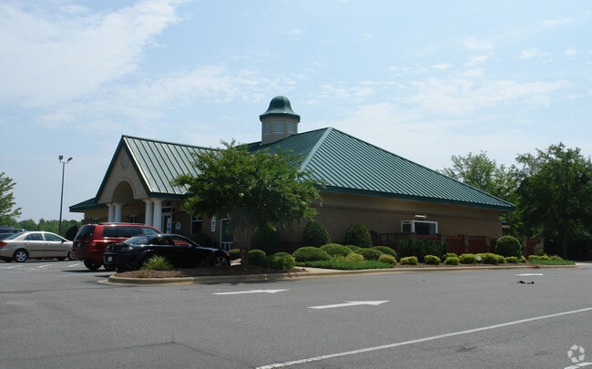
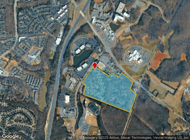
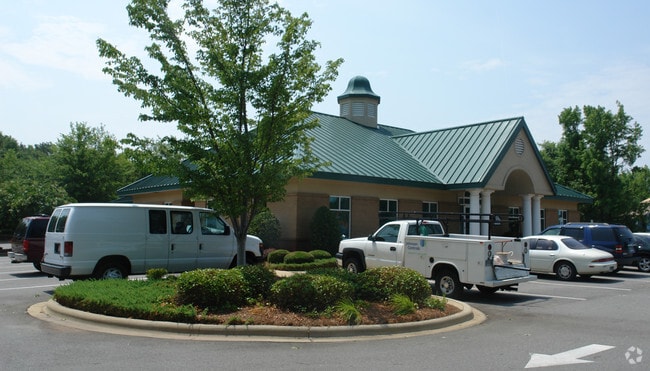
Property Record
320 Sentinel Way, Fort Mill, SC 29715
NEARBY LISTINGS FOR SALE OR LEASE
Property Detail
320 Sentinel Way
0200901003
Peachtree Place
Commercialnec
(58.38 AC), LESS 0.256AC PEACHTREE PLACE APTS PT TR B MP 2
X
York
45091C0214F
South Carolina
2025
58.12 AC
2025
York County
061004
Charlotte
8,777 SF
Charlotte-Concord-Gastonia, NC-SC
DEMOGRAPHICS near 320 Sentinel Way
1 Mile
3 Mile
5 Mile
2024 Total Population
4,448
39,765
124,304
2029 Population
5,018
44,947
140,669
Pop Growth 2024-2029
+ 12.81%
+ 13.03%
+ 13.17%
Average Age
38
38
38
2024 Total Households
1,684
14,979
46,508
HH Growth 2024-2029
+ 13.18%
+ 13.31%
+ 13.41%
Median Household Inc
$101,574
$102,443
$101,263
Avg Household Size
2.60
2.60
2.70
2024 Avg HH Vehicles
2.00
2.00
2.00
Median Home Value
$357,465
$400,025
$371,517
Median Year Built
2001
2006
2005
Nearby Places
Map Layers
Map Styles
 Street
 Aerial
- Restaurants
- Banks
- Shops
- Fitness
- Groceries
PUBLIC TRANSPORTATION
AIRPORT
Charlotte/Douglas International
DRIVE
WALK
Distance
Charlotte/Douglas International
28 min
15.6 mi
Concord-Padgett Regional
DRIVE
WALK
Distance
Concord-Padgett Regional
46 min
32.7 mi
Freight Ports
North Charleston Terminal
DRIVE
WALK
Distance
North Charleston Terminal
207 min
183.5 mi
Nearby Properties
Address
Land Use
TOTAL SIZE
Lot Size
Zoning
Address
Land Use
TOTAL SIZE
Lot Size
Zoning
151,844 SF
11.65 AC
Address
Land Use
TOTAL SIZE
Lot Size
Zoning
401.79 AC
Address
Land Use
TOTAL SIZE
Lot Size
Zoning
335.85 AC
AGC
Address
Land Use
TOTAL SIZE
Lot Size
Zoning
64,338 SF
0.83 AC
Address
Land Use
TOTAL SIZE
Lot Size
Zoning
178,585 SF
17.44 AC
Address
Land Use
TOTAL SIZE
Lot Size
Zoning
167.49 AC
MULTIPLEZ
Address
Land Use
TOTAL SIZE
Lot Size
Zoning
162.78 AC
RCI
Address
Land Use
TOTAL SIZE
Lot Size
Zoning
64,113 SF
6.69 AC
Address
Land Use
TOTAL SIZE
Lot Size
Zoning
197,864 SF
39.37 AC
Address
Land Use
TOTAL SIZE
Lot Size
Zoning
79,600 SF
9.58 AC
Address
Land Use
TOTAL SIZE
Lot Size
Zoning
11,056 SF
1.89 AC
RDI
Address
Land Use
TOTAL SIZE
Lot Size
Zoning
7,772 SF
4.75 AC
Address
Land Use
TOTAL SIZE
Lot Size
Zoning
598,425 SF
102 AC
ID
Address
Land Use
TOTAL SIZE
Lot Size
Zoning
26,733 SF
34.66 AC
PD
Address
Land Use
TOTAL SIZE
Lot Size
Zoning
28,569 SF
0.39 AC
Address
Land Use
TOTAL SIZE
Lot Size
Zoning
2,238 SF
38.21 AC
RCI
Address
Land Use
TOTAL SIZE
Lot Size
Zoning
25,554 SF
14.18 AC
PD
Address
Land Use
TOTAL SIZE
Lot Size
Zoning
18,990 SF
0.23 AC
Address
Land Use
TOTAL SIZE
Lot Size
Zoning
33,312 SF
14.71 AC
Address
Land Use
TOTAL SIZE
Lot Size
Zoning
131,716 SF
13.89 AC
Address
Land Use
TOTAL SIZE
Lot Size
Zoning
21,761 SF
30.22 AC
AGC
Address
Land Use
TOTAL SIZE
Lot Size
Zoning
155,948 SF
17.02 AC
UD
Address
Land Use
TOTAL SIZE
Lot Size
Zoning
48,912 SF
14.66 AC
Address
Land Use
TOTAL SIZE
Lot Size
Zoning
19,426 SF
16.39 AC
PUD
Address
Land Use
TOTAL SIZE
Lot Size
Zoning
280,000 SF
35.63 AC
ID
Address
Land Use
TOTAL SIZE
Lot Size
Zoning
10.57 AC
Address
Land Use
TOTAL SIZE
Lot Size
Zoning
39,312 SF
13.11 AC
Address
Land Use
TOTAL SIZE
Lot Size
Zoning
24,200 SF
2.18 AC
Address
Land Use
TOTAL SIZE
Lot Size
Zoning
4,058 SF
28.55 AC
AGC
Address
Land Use
TOTAL SIZE
Lot Size
Zoning
16.05 AC
The World's #1 Commercial Real Estate Marketplace
Connect with us
© 2025 CoStar Group
The information above has been obtained from sources believed reliable. While we do not doubt its accuracy we have not verified it and make no guarantee, warranty or representation about it. It is your responsibility to independently confirm its accuracy and completeness. Any projections, opinions, assumptions, or estimates used are for example only and do not represent the current or future performance of the property. The value of this transaction to you depends on tax and other factors which should be evaluated by your tax, financial, and legal advisors. You and your advisors should conduct a careful, independent investigation of the property to determine to your satisfaction the suitability of the property for your needs.