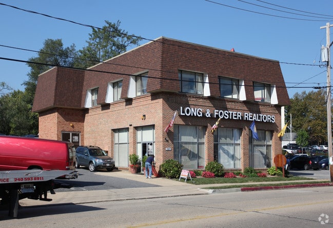
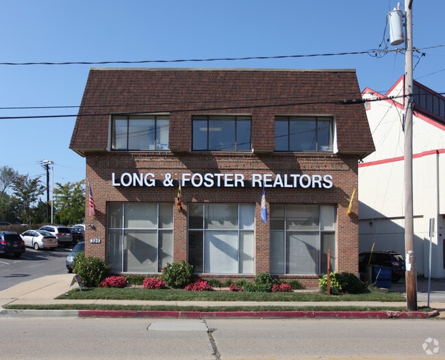
Property Record
320 Sixth St, Annapolis, MD 21403

Save to a Folder
{{folder.Name}}
{{folder.ListingIds.length}} Properties
{{folder.ListingIds.length}} Property
Create a New Folder
Property Detail
320 Sixth St
06-000-01908077
LT 22 PT LT 25 EASTPORT
Storebuilding
Anne Arundel
B3
Maryland
B and X Area of moderate flood hazard, usually the area between the limits of the 100-year and 500-year floods.
22
2024
0.31 AC
2025
Annapolis
706302
Baltimore
12,800 SF
Baltimore-Columbia-Towson, MD
NEARBY LISTINGS FOR SALE OR LEASE
DEMOGRAPHICS near 320 Sixth St
1 mile
3 mile
5 mile
2025 Total Population
14,403
62,280
107,252
2030 Population
14,900
63,665
109,424
Pop Growth 2025-2030
+ 3.45%
+ 2.22%
+ 2.03%
Average Age
44
41
42
2025 Total Households
6,784
25,651
43,394
HH Growth 2025-2030
+ 3.46%
+ 2.28%
+ 2.04%
Median Household Inc
$112,457
$112,871
$119,068
Avg Household Size
2.00
2.30
2.40
2025 Avg HH Vehicles
2.00
2.00
2.00
Median Home Value
$802,004
$607,743
$605,056
Median Year Built
1968
1977
1981
Nearby Places
Map Layers
Map Styles
 Street
 Aerial
Layers
 Traffic
 Biking
Places
Listings with unknown addresses are not visible on the map
- Restaurants
- Banks
- Shops
- Fitness
- Groceries
PUBLIC TRANSPORTATION
AIRPORT
Baltimore/Washington International Thurgood Marshall
Drive
Walk
Distance
Baltimore/Washington International Thurgood Marshall
37 min
25.6 mi
Ronald Reagan Washington Ntl
Drive
Walk
Distance
Ronald Reagan Washington Ntl
54 min
37.2 mi
Freight Ports
Port of Baltimore
Drive
Walk
Distance
Port of Baltimore
43 min
30.8 mi
Nearby Properties
Address
Land Use
TOTAL SIZE
Lot Size
Zoning
Address
Land Use
TOTAL SIZE
Lot Size
Zoning
717,491 SF
26.28 AC
C2
Address
Land Use
TOTAL SIZE
Lot Size
Zoning
6,400 SF
31.17 AC
C1
Address
Land Use
TOTAL SIZE
Lot Size
Zoning
31.16 AC
R4
Address
Land Use
TOTAL SIZE
Lot Size
Zoning
434,112 SF
822.11 AC
R1
Address
Land Use
TOTAL SIZE
Lot Size
Zoning
406,976 SF
18.98 AC
R2
Address
Land Use
TOTAL SIZE
Lot Size
Zoning
58.99 AC
R2
Address
Land Use
TOTAL SIZE
Lot Size
Zoning
250,163 SF
2.19 AC
P
Address
Land Use
TOTAL SIZE
Lot Size
Zoning
577,560 SF
3.71 AC
C2
Address
Land Use
TOTAL SIZE
Lot Size
Zoning
346,335 SF
16.42 AC
R22
Address
Land Use
TOTAL SIZE
Lot Size
Zoning
591,962 SF
6.43 AC
BCE
Address
Land Use
TOTAL SIZE
Lot Size
Zoning
271,003 SF
1 AC
TC
Address
Land Use
TOTAL SIZE
Lot Size
Zoning
198,795 SF
36 AC
R2
Address
Land Use
TOTAL SIZE
Lot Size
Zoning
435,081 SF
2.62 AC
TC
Address
Land Use
TOTAL SIZE
Lot Size
Zoning
248,820 SF
24.92 AC
R2
Address
Land Use
TOTAL SIZE
Lot Size
Zoning
309,756 SF
0.01 AC
R-22
Address
Land Use
TOTAL SIZE
Lot Size
Zoning
146,329 SF
1.26 AC
WMC
Address
Land Use
TOTAL SIZE
Lot Size
Zoning
272,275 SF
3.11 AC
P
Address
Land Use
TOTAL SIZE
Lot Size
Zoning
8.78 AC
R3
Address
Land Use
TOTAL SIZE
Lot Size
Zoning
189,134 SF
1.02 AC
MX
Address
Land Use
TOTAL SIZE
Lot Size
Zoning
14.42 AC
R3
Address
Land Use
TOTAL SIZE
Lot Size
Zoning
117,577 SF
6.92 AC
R2
Address
Land Use
TOTAL SIZE
Lot Size
Zoning
37.74 AC
R3
Address
Land Use
TOTAL SIZE
Lot Size
Zoning
118,260 SF
34.01 AC
Address
Land Use
TOTAL SIZE
Lot Size
Zoning
175,294 SF
13.82 AC
W1
Address
Land Use
TOTAL SIZE
Lot Size
Zoning
199,311 SF
1 AC
MX
Address
Land Use
TOTAL SIZE
Lot Size
Zoning
233,141 SF
4.21 AC
MX
Address
Land Use
TOTAL SIZE
Lot Size
Zoning
114,102 SF
1.42 AC
P
Address
Land Use
TOTAL SIZE
Lot Size
Zoning
16.29 AC
R3
Address
Land Use
TOTAL SIZE
Lot Size
Zoning
Address
Land Use
TOTAL SIZE
Lot Size
Zoning
The World's #1 Commercial Real Estate Marketplace
Connect with us
© 2026 CoStar Group
The information above has been obtained from sources believed reliable. While we do not doubt its accuracy we have not verified it and make no guarantee, warranty or representation about it. It is your responsibility to independently confirm its accuracy and completeness. Any projections, opinions, assumptions, or estimates used are for example only and do not represent the current or future performance of the property. The value of this transaction to you depends on tax and other factors which should be evaluated by your tax, financial, and legal advisors. You and your advisors should conduct a careful, independent investigation of the property to determine to your satisfaction the suitability of the property for your needs.