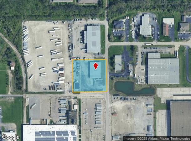
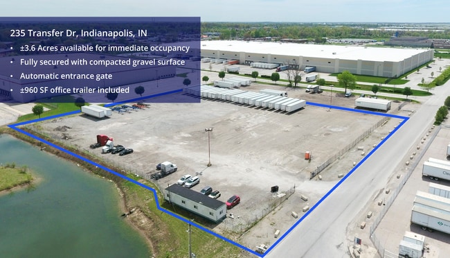
Property Record
320 Transfer Dr, Indianapolis, IN 46214

Current Lease Availabilities
NEARBY LISTINGS FOR SALE OR LEASE
Property Detail
320 Transfer Dr
49-12-03-108-004.000-900
PT E1/2 SW1/4 S3 T15 R2 BEG 35 W & 474.3 S OFNE COR., S 309.14, W 324.69, N 308.53, E323.63 TO BEG. 2.298AC
Warehouse
Marion
X
Indiana
18097C0118F
3
2023
2.30 AC
2024
W Rockville/Cnty Clb
340102
Indianapolis
15,000 SF
Indianapolis-Carmel-Anderson, IN
DEMOGRAPHICS near 320 Transfer Dr
1 Mile
3 Mile
5 Mile
2024 Total Population
8,159
79,918
188,679
2029 Population
8,001
80,352
191,603
Pop Growth 2024-2029
(1.94%)
+ 0.54%
+ 1.55%
Average Age
40
37
36
2024 Total Households
3,488
31,498
72,127
HH Growth 2024-2029
(1.75%)
+ 0.34%
+ 1.30%
Median Household Inc
$52,362
$56,458
$56,501
Avg Household Size
2.30
2.50
2.50
2024 Avg HH Vehicles
1.00
2.00
2.00
Median Home Value
$158,325
$160,120
$159,004
Median Year Built
1971
1981
1978
Nearby Places
Map Layers
Map Styles
 Street
 Aerial
- Restaurants
- Banks
- Shops
- Fitness
- Groceries
PUBLIC TRANSPORTATION
COMMUTER RAIL
DRIVE
WALK
Distance
15 min
8.3 mi
AIRPORT
Indianapolis International
DRIVE
WALK
Distance
Indianapolis International
21 min
8.5 mi
Nearby Properties
Address
Land Use
TOTAL SIZE
Lot Size
Zoning
Address
Land Use
TOTAL SIZE
Lot Size
Zoning
1,340,481 SF
63.99 AC
ZO01
Address
Land Use
TOTAL SIZE
Lot Size
Zoning
52.77 AC
Address
Land Use
TOTAL SIZE
Lot Size
Zoning
315,254 SF
48.71 AC
Address
Land Use
TOTAL SIZE
Lot Size
Zoning
6,486 SF
17.63 AC
Address
Land Use
TOTAL SIZE
Lot Size
Zoning
5,280 SF
97.87 AC
ZO01
Address
Land Use
TOTAL SIZE
Lot Size
Zoning
18,072 SF
29.73 AC
Address
Land Use
TOTAL SIZE
Lot Size
Zoning
1,413,414 SF
115.43 AC
ZO01
Address
Land Use
TOTAL SIZE
Lot Size
Zoning
145,816 SF
1.07 AC
Address
Land Use
TOTAL SIZE
Lot Size
Zoning
415,877 SF
55.83 AC
ZO01
Address
Land Use
TOTAL SIZE
Lot Size
Zoning
3,518 SF
16.76 AC
Address
Land Use
TOTAL SIZE
Lot Size
Zoning
578,964 SF
35.50 AC
ZO01
Address
Land Use
TOTAL SIZE
Lot Size
Zoning
27,327 SF
15 AC
Address
Land Use
TOTAL SIZE
Lot Size
Zoning
19,314 SF
32.88 AC
ZO01
Address
Land Use
TOTAL SIZE
Lot Size
Zoning
2,737 SF
9.65 AC
Address
Land Use
TOTAL SIZE
Lot Size
Zoning
3,878 SF
17.76 AC
Address
Land Use
TOTAL SIZE
Lot Size
Zoning
7,364 SF
9.20 AC
Address
Land Use
TOTAL SIZE
Lot Size
Zoning
Address
Land Use
TOTAL SIZE
Lot Size
Zoning
3,618 SF
31.13 AC
ZO01
Address
Land Use
TOTAL SIZE
Lot Size
Zoning
30,545 SF
3.41 AC
ZO01
Address
Land Use
TOTAL SIZE
Lot Size
Zoning
3,706 SF
30.57 AC
ZO01
Address
Land Use
TOTAL SIZE
Lot Size
Zoning
1,868 SF
14.50 AC
ZO01
Address
Land Use
TOTAL SIZE
Lot Size
Zoning
28,400 SF
22.04 AC
ZO01
Address
Land Use
TOTAL SIZE
Lot Size
Zoning
1,700 SF
40.37 AC
ZO01
Address
Land Use
TOTAL SIZE
Lot Size
Zoning
5,616 SF
9.34 AC
Address
Land Use
TOTAL SIZE
Lot Size
Zoning
2,288 SF
21.42 AC
Address
Land Use
TOTAL SIZE
Lot Size
Zoning
3,802 SF
12.25 AC
Address
Land Use
TOTAL SIZE
Lot Size
Zoning
120,734 SF
21.48 AC
Address
Land Use
TOTAL SIZE
Lot Size
Zoning
203,398 SF
25.57 AC
Address
Land Use
TOTAL SIZE
Lot Size
Zoning
641,389 SF
44.90 AC
Address
Land Use
TOTAL SIZE
Lot Size
Zoning
216,914 SF
29.32 AC
The World's #1 Commercial Real Estate Marketplace
Connect with us
© 2026 CoStar Group
The information above has been obtained from sources believed reliable. While we do not doubt its accuracy we have not verified it and make no guarantee, warranty or representation about it. It is your responsibility to independently confirm its accuracy and completeness. Any projections, opinions, assumptions, or estimates used are for example only and do not represent the current or future performance of the property. The value of this transaction to you depends on tax and other factors which should be evaluated by your tax, financial, and legal advisors. You and your advisors should conduct a careful, independent investigation of the property to determine to your satisfaction the suitability of the property for your needs.